

Massive and dangerous Hurricane Sandy has grown to record size as it barrels northeastwards along the North Carolina coast... -Jeff Masters, Weather Underground, Oct. 28 2012.Science paper, 2010:
Fewer but fiercer and more-destructive hurricanes will sweep the Atlantic Basin in the 21st century as climate change continues, a new modeling study by U.S. government researchers suggests. -commentary by Richard Kerr on Bender, M.A. et al., 2010. Science, 327(5964), pp.454–458.Hurricane Sandy, 2012
If ‘Frankenstorm’ pans out to be as powerful and odd as the models currently forecast, then it may be said that this storm will be unique in the annals of American weather history. -Christopher Burt, Weather Underground, Oct. 26, 2012Report by the National Research Council, 2010:
the destructive energy of Atlantic hurricanes is likely to increase in this century as sea surface temperature rises -"America's Climate Choices: Adapting to the Impacts of Climate Change". National Research Council, National Academies of Sciences, 2010Where I sit in New Jersey, we are preparing for a direct hit from a record-setting hurricane. We all know that no one event can be blamed on climate change. But this freak storm certainly seems to match the warnings we've gotten over the past decade. Let's consider what exactly makes Hurricane Sandy so "freak", and whether this freakiness may be a harbinger of the new normal. There are at least three factors making Hurricane Sandy such a threat: 1) Warm sea surface temperatures, 2) A "blocking pattern" shoving the storm back on shore, 3) A merger with a winter storm.
1) Warmer oceans. Global warming has been raising sea surface temperatures around the world. The water off New England set record highs this year, meaning that Sandy will have more energy to feed from than usual as she churns North.

Sandy will draw energy from the abnormally warm ocean just off the Atlantic coast. Note this is in Celsius. The water off NJ is about 5°F higher than average, and set record highs in 2012. Source: NOAA National Hurricane Center.Yes, there are natural variations that affect sea surface temperatures, in particular the Atlantic Multidecadal Oscillation. But consider the plot below showing North Atlantic temperature changes from normal. The ~60 year oscillation is clear, but so too is the fact that each peak is stronger than the one before.
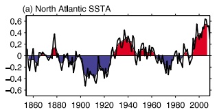
North Atlantic sea surface temperature anomalies (°C). Source: Wang, C.&Dong, S., 2010. Geophys. Res. Lett, 37, p.L08707.2) Blocking pattern. A blocking pattern is essentially when the jet stream gets kinked. The current kink is pushing Sandy back on shore where most hurricanes would keep veering out to sea. A recent analysis showed that blocking patterns like this are more likely thanks to a warming Arctic. As Arctic sea ice keeps melting to new record lows, the darker water absorbs more heat, which it later releases to the atmosphere. The effect of all this is a weaker jet stream more prone to kinking.
3) Merging with a winter storm. Ok, so actually, this one's not climate related.
Ok, so prediction: rising temperatures will give hurricanes warmer oceans to feed from, and more moisture to dump on us, making them more destructive. Observation: we are about to get walloped by what looks to be a history-making storm. Prediction: ocean temperatures will keep rising and blocking patterns will become more frequent. Observation: Hurricane Sandy is feeding off of record ocean temperatures and a kinked jet stream.
Now, it is certainly true that we still don't completely understand hurricanes. It is true that models are not perfect. It is true that Hurricane Sandy could have happened even without climate change. It is true that climate change doesn't "cause" an event, just like doping alone won't win you the Tour de France. And, as always, it is true that we should not draw conclusions from a single event. So then, is Hurricane Sandy just a freak event, or is she an instructive example of what we should expect more often? Let's look at a paper just published in PNAS, which put together a long-term data set of hurricane activity based on storm surges. That means this is not a model – it is empirical evidence from the past 90 years.
We observe that [hurricane activity is greater in] warm years... than cold years and that the relative difference... is greatest for the most extreme events. -Grinsted, A., Moore, J.C.&Jevrejeva, S., 2012. Proceedings of the National Academy of Sciences.Climate change is happening, this is why we care.
More:
Hurricane Sandy as 'super storm': Is climate change a factor? (LA Times)
Hurricane Sandy set to deliver massive blow to East Coast (Climate Central)
The Frankenstorm in climate context (dot Earth)


Comments