


A newly identified fault that runs under the Adriatic Sea is actively building more of the famously beautiful Dalmatian Islands and Dinaride Mountains of Croatia, according to a new research report.
Geologists had previously believed that the Dalmatian Islands and the Dinaride Mountains had stopped growing 20 to 30 million years ago. From a region northwest of Dubrovnik, the new fault runs northwest at least 200 km (124 miles) under the sea floor.
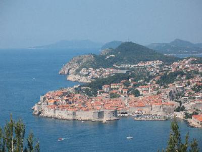
The Croatian coast and the 1,185 Dalmatian Islands are an increasing popular tourist destination. Dubrovnik, known as "the Pearl of the Adriatic," is a UNESCO-designated World Heritage site.
At the fault, the leading edge of the Eurasian plate is scraping and sliding its way over a former piece of the African plate called the South Adria microplate, said lead researcher Richard A. Bennett of The University of Arizona in Tucson.

"It's a collision zone," said Bennett, a UA assistant professor of geosciences. "Two continents are colliding and building mountains."
Bennett and his colleagues found that Italy's boot heel is moving toward the Croatian coast at the rate of about 4 mm (0.16 inches) per year. By contrast, movement along parts of California's San Andreas fault can be 10 times greater.
The region along the undersea fault has no evidence of large-magnitude earthquakes occurring in the last 2,000 years. However, if the fault is the type that could move abruptly and cause earthquakes, tsunami calculations for the region need to be redone, he said.
"It has implications for southern Italy, Croatia, Montenegro and Albania."
At its southern end, the newly identified fault connects to a seismically active fault zone further south that caused a large-magnitude earthquake in Dubrovnik in 1667 and a magnitude 7.1 earthquake in Montenegro in 1979.
Geologists have been trying to figure out how the collision between the African and Eurasian continents is being played out in the Mediterranean.
Bennett was studying the geology of Italy's Alps and Apennine Mountains and realized he needed to know more about the mountains on the other side of the Adriatic. The Croatian mountains and coasts are relatively understudied, in part because of years of political turmoil in the region, he said. So he teamed up with Croatian geologists.
Bennett is an expert in a technique called geodesy that works much like the GPS in a car.
"We put GPS units on rocks and watch them move around," he said. "We leave an antennae fixed to a rock and record its movement all the time. We basically just watch it move."
Just as the GPS in a rental car uses global positioning satellites to tell where the car is relative to a desired destination, the geodesy network can tell where one antenna and its rock are relative to another antenna.
Recent improvements in the technology make it possible to see very small movements of the Earth. He said, "In Croatia we can resolve motions at the level of about one mm per year."
The researchers found that the motion between Italy’s boot heel and Eurasia is absorbed at the Dinaride Mountains and Dalmatian Islands. Combining geodetic data with other geological information revealed that the movement is accommodated by a previously unknown fault under the Adriatic.
Bennett likens movement of the Eurasian plate to a snowplow blade piling up snow in front of it. The snow represents the sea floor being pushed up to form the Dalmatian Islands and the Dinaride Mountains.
"You can see hints of new islands out there," he said.
But those islands may not provide seaside vacations forever. Bennett said the Adriatic Sea is closing up at the rate of 4.5 km (2.8 miles) per million years. If things continue as they are now, he calculates the eastern and western shores of the Adriatic Sea will meet in about 50 to 70 million years.
"This new finding is an important piece in the puzzle to understanding Mediterranean tectonics," he said.
He plans to set out more antennas to learn more about current movement of the region and to figure out what the fault has been doing for the past 40 million years. The additional information will also help gauge the region's earthquake potential.
Bennett said, "We want to see if the fault is freely slipping or is accumulating strain and therefore may produce a large earthquake in the future."
Bennett and his colleagues published their article, "Eocene to present subduction of southern Adria mantle lithosphere beneath the Dinarides," in the January issue of the journal Geology. His co-authors are UA geoscientists Sigrún Hreinsdóttir and Goran Buble; Tomislav Bašiæ of the University of Zagreb and the Croatian Geodetic Institute; Željko Baèiæ and Marijan Marjanoviæ of the Croatian State Geodetic Administration in Zagreb; Gabe Casale, Andrew Gendaszek and Darrel Cowan of the University of Washington in Seattle.
The research was funded by the Croatian Geodetic Administration and the U.S. National Science Foundation.


Comments