


A new technique that helps forecasters continuously monitor landfalling hurricanes, giving them frequent and detailed images of a storm's location, will be implemented this summer.
The new system, developed by researchers at the National Center for Atmospheric Research (NCAR) in Boulder, Colo., and the Naval Research Laboratory (NRL) in Washington, D.C., will be implemented at the National Hurricane Center (NHC).
The technique, known as VORTRAC (Vortex Objective Radar Tracking and Circulation), was successfully tested by the hurricane center last year. The system, which relies on existing Doppler radars along the U.S. coast, provides details on hurricane winds and central pressure every six minutes, indicating whether the storm is gathering strength in the final hours before reaching shore.
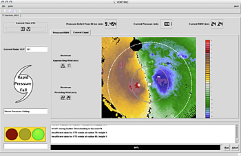
One of VORTRAC's strengths is that it can use radar data to calculate the barometric pressure at the center of a hurricane, a key measure of its intensity.
"VORTRAC allows us to take the wind measurements from the radar, turn the crank, and have a central pressure drop out of a calculation," says Colin McAdie, a meteorologist at NHC. "This will be a valuable addition to the tools available to the forecaster."
Rapidly intensifying storms can catch vulnerable coastal areas by surprise. Last year, Hurricane Humberto struck near Port Arthur, Texas, after unexpectedly strengthening from a tropical depression to a hurricane in less than 19 hours. In 2004, parts of Florida's southwest coast were caught unprepared when Hurricane Charley's top winds increased from 110 to 145 miles per hour in just six hours as the storm neared land.
NCAR scientist Wen-Chau Lee and his collaborators applied VORTRAC retroactively to the two hurricanes and found that the technique would have accurately tracked their quick bursts in intensity.
"VORTRAC has demonstrated that it can capture sudden intensity changes in potentially dangerous hurricanes in the critical time period when these storms are nearing land," NCAR's Michael Bell said.
VORTRAC uses the Doppler radar network established by NOAA in the 1990s.
About 20 of these radars are scattered along the Gulf and Atlantic coastlines from Texas to Maine. Each radar can measure winds blowing toward or away from it, but no single radar could provide an estimate of a hurricane's rotational winds and central pressure until now.
The VORTRAC team developed a series of mathematical formulas that combine data from a single radar near the center of a landfalling storm with general knowledge of Atlantic hurricane structure in order to map the approaching system's rotational winds. VORTRAC also infers the barometric pressure in the eye of the hurricane, a very reliable index of its strength.
"By merging several techniques, we can now provide a missing link in short-term hurricane prediction," NRL's Paul Harasti says.
Forecasters using VORTRAC can update information about a hurricane each time a Doppler radar scans the storm, which can be as often as about every six minutes. Without such a technique, forecasters would need at least two coastal radars in close proximity to each other in order to obtain the same information. But most of the network's radars are too far apart to qualify.
Each radar can sample conditions out to about 120 miles. This means VORTRAC can track an incoming hurricane for at least several hours, and possibly even as long as a day or more, depending on the storm's speed, trajectory, and size.
To monitor the winds of a landfalling hurricane, forecasters now rely on aircraft to drop instrument packages into the storm that gather data on winds and pressure. But due to flight logistics, the aircraft can take readings no more than every few hours, which means that coastal communities may not be swiftly alerted to changes in approaching hurricanes.
VORTRAC may also help improve long-range hurricane forecasts by using data from airborne Doppler radars or spaceborne radars to produce detailed information about a hurricane that is far out to sea.
Forecasters could input the data to computer models to improve three- and five-day forecasts.
-NSF-


Comments