


A version of this article with less scientific details (so easier to read) can be found here.
A team of Portuguese researchers have developed a mathematical tool that can classify any region in the world according to its pattern of development into one of 5 types, each with specific characteristics and predictable behaviours that call for different interventions and policy measures. The discovery, just out in Nature’s Scientific Reports, represents a major step towards a new type to city planning - objective and most importantly, independent of personal visions, interests and politics.
Jorge M. Pacheco, one of the scientists involved inthe study explains “what this means is that now we finally can have a unified characterisation of urban areas worldwide that pave the way for city plannersall over the world to collaborate, whether comparing urban policies orforecasting typical future scenarios and procedures to deal with them.”
“And the software that does all this “says Pacheco “is not only effective, but easy to use, can assess any region in the worldand be run in any computer. All we needis people’s interest; the technology is free and is here. ”
The logic behind the development of our cities is, to anyone that ever lived in one, a mysterious affair. Like living organisms, buildings grow fuelled by the desires and views of the individuals that live and rule in the cities.An objective approach to urban development has been needed for a long time butis now more urgent than ever with the rapid growth of cities in countries withfast economical growth like India and China, where too often cement jungles are destroying people’s lives.
This, however, has not proved easy, as cities arecomplex evolving structures. But recently, scientists started to think thatmaybe the solution could be found in something call “fractals”.
Simply defined, fractals are complex structures wherethe same geometric pattern is repeated whether you look at the whole, or zoominto parts of it. This can be seen in landscapes, clouds but more importantly,also in cities (although not all of them). Think of those rectangular housesand, at bigger scale, courtyards and squares that we see repeated over and overin cities throughout the world. To analyse a city in this way can extremelyadvantageous because it avoids the need to think about different scales (as afractal is the same at all scales), making the understanding of how the citydevelops much, much easier.
In the work now published, Sara Encarnação, Jorge M.Pacheco and colleagues from the ATP-Group at the Institute forInterdisciplinary Research and the Centre for Geographical Studies and RegionalPlanning, at the NOVA University, both in Lisbon, use the Metropolitan Area ofLisbon (MAL) or “Big Lisbon” - which includes the city, as well as its growingsuburbs and a ring of rural regions – as a case study, from where to developthe model.
The first step was to understand MAL development, and for that they calculated its fractal dimensions (D).
Fractal dimensions (D) in cities tells us to how thebuilt up area is distributed on the surface and how dense or fragmented is itsspatial patterning, going from 0.0 (no buildings) through 1.0 (where built-upareas are still very dispersed), up to 2.0 (where urbanised areas have grownand became compacted) and all the values in between. Here also D tends to grow with time, as built-up areas tend to expand as cities becoming “denser” and“denser”.
Although there has been other analyses of cities asfractals, until now this has been done using the D of the whole city. Pachecoand colleagues go a step further; first they divide the MAL territory intocells (each corresponding to a territory of 1Km2) and, using data on the urbandevelopment from three different dates - 1960, 1990 and 2004, calculate thefractal dimension of each cell.
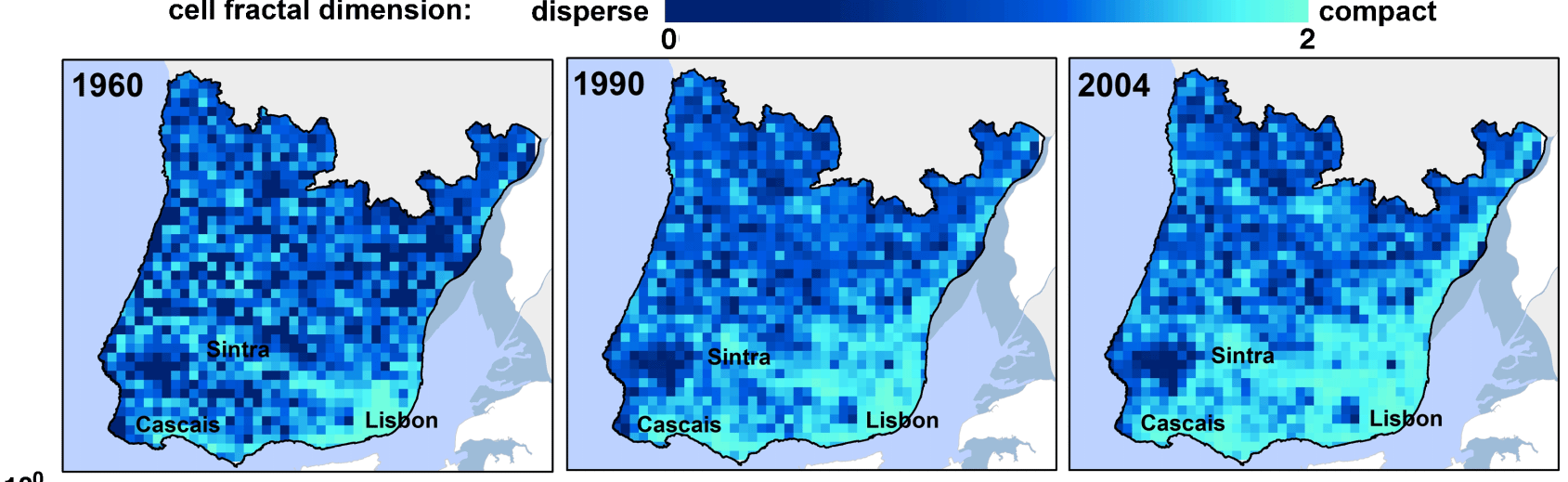
Figure 1
The results, seen in Fig.1, provide them with anextremely detailed account of how this specific urban landscape has changedwith time. In fact, now not only they have how much territory is built-up orfree in each cell, and how this changes with time, but also their correspondingD.
Since in cities D reflects how dense or fragmented itsspatial patterning is, it is easy to see that if the urbanised plots keepexpanding within a cell/region, eventually their D has to increase. And whatthe researchers realised at this point, was that the fraction of built-up areain each D had to fall within certain limits, and that this relationship (orrule) could be defined mathematically. From here the door for the developmentof a theoretical model to describe city development opened.
And once this first relationship was mathematicallydefined, the researchers went to deducetwo other parameters: S, that is the number of different ways to put buildingsinside a cell (or any area) in order to obtain a specific D, and S’ – which measureshow fast S changes.
Now when they plot in a graph the various values of Sand S’ against their corresponding fractal dimensions (D) Encarnação andcolleagues could define 5 very different Types of development.
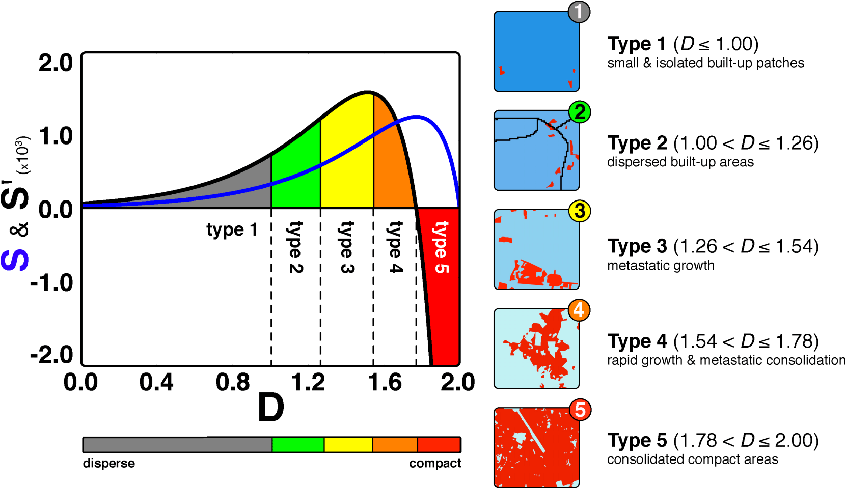 Fig 2
Fig 2
As Fig 2 shows these range from Type 1, where built-upareas are scarce and isolated, and land is used mostly for agriculture andforest (low D), to Type 5, where building is close to saturation and the spacefor new constructions is rare (high D).
To city planners, however, Type 3 and 4 are the ones of real interest. In fact, these areregions with free land to built (far from the saturation seen in Type 5), butalso a very high S (what means many possible ways to arrange what will be built).And here is where their problem lays - the combination of space to build andpossibilities to rearrange the built-up, marks these regions at the highestrisk of uncontrolled (chaotic) growth.
Additionally S’(S speed of change) is still growing inType 3 regions, which are characterised by construction of dispersed built-upareas, a growth typical of urban sprawl (the rapid expansion of urban areasknown to bring planning, social and even health issues). In Type 4 areas, onthe other hand, S’ is declining (as free land is less available) leadinginstead to the consolidation of existing building into large urban blocks andmaking these areas much less problematic than Type 3.
But can the model keep up with real life? Back to MAL the researchers calculated the Type for each of cells, and, after allocating a different colour to each Type (see Fig 3), plot the information back into the maps.
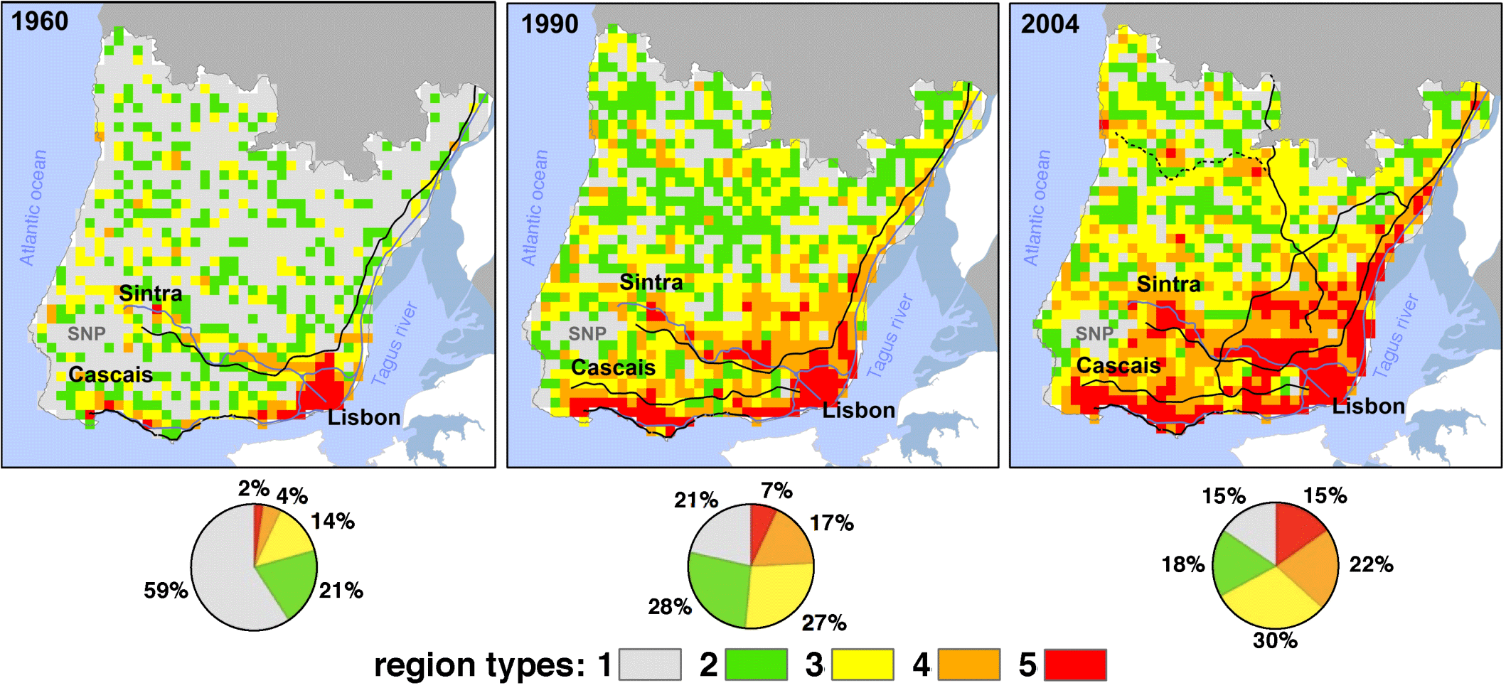
Fig 3
What they discovered was an extraordinary agreementbetween what the model predicts and what planners known about MAL developmentthroughout the years. For example, several spots of Type 3 and 4 areas detectedin 1990 (that by 2004 have undergone huge growth) are regions known to have suffereduncontrolled housing due to lack of effective regulation, and which have nowhuge urbanisation and social problems
Even more important, the model provides warnings; in2004 it is already possible to spot, next to a new road in the northern peripheryof Lisbon, several Type 3 areas, which, if left without regulation, will nodoubt be at risk of yet more chaotic development.
Throughout history, cities tend to move from Type 1 toType 5 (as D increases), but it is how they get from one to the other thatdetermines their inhabitants quality of life. Encarnação and Pacheco’s work reveals that metropolitan areas behavelike living evolving organisms that need effective, but also flexible planningand regulation. By developing a way to classify what is happening as it ishappening, uncovering in real time those areas requiring more attention,Encarnação and Pacheco’s model brings this flexibility.
Pacheco adds “Now imagine a Google map with a versionof the world in which every patch of land will be cartographically identifiedaccording to the model, and you can see how much easier and quicker would be tomake the right planning decisions”.
References
Scientific Reports 2, Article number: 527 doi:10.1038/srep00527
“Fractalcartography of urban areas” by Sara Encarnação, Marcos Gaudiano, Francisco C.Santos, José A. Tenedório&Jorge M. Pacheco
Link to the original article
http://www.nature.com/srep/2012/120724/srep00527/full/srep00527.html (open access)


Comments