

Short summary: we have had wild fires for many years now in the Amazon, even in the tropical rainforest - mainly started by humans for forest clearing and ranching. It is not enough to impact significantly on the Paris agreement pledges yet, though it is important in the long term if this continues for decades. It does of course have major and immediate impacts on forest residents, nature services and the biodiversity in Brazil.
This image is being shared widely, for instance in National Geographic's "The Amazon is burning at record rates - and deforestation is to blame". Similarly, the BBC is reporting it as 'Record number of fires' in Brazilian rainforest
Yet, NASA's own description for this photo says that it is burning at close to the average for the last 15 years. So, what is going on here?
It turns out that the earlier 13th August article gives the number of fires since 1st January but they use 1st May as the start date for the August 19 update.
There's been a rapid increase of fires in the second half of August still continuing as of 24th August. it was at average levels or below average through to early August but had a huge uptick and is now close to the 2016 levels from 1st January and if it continues likely crosses them soon. But if you count from 1st May it is already way above recent previous years and close to rates last seen over a decade ago.
The new fires are more intense, near roads and show all the signs of being deliberate fires for deforestation. In addition local farmers in Para district organized a "day of fire" on August 10th to show to Bolsonaro that they are ready to work and that they need to use fire to do so. So there is a clear link here. Bolsonaro however, in response to pressure internationally and also locally within Brazil has responded instead by sending in the army to stop the fires and he says that it is his duty to protect the Amazon. He also said clearly that these fires are illegal. There is also an investigation underway into the "day of fire".
If they can stop the illegal fires this could make a big difference to deforestation figures for this year and indeed future years. There are more sustainable ways to increase the productivity of Brazil using existing land without impacting on the forest. See section RANCHING COULD BE MUCH MORE PRODUCTIVE WITH JUST THE EXISTING LAND (below)
(skip to NASA'S STATEMENT ABOUT EARLIER FIRES THROUGH TO MID AUGUST )
APOLOGIES - UPDATE FROM NASA FROM 19TH AUGUST - THEY NOW CONFIRM INPE INSTEAD OF SAYING IT IS BELOW AVERAGE
Previous version of this article was mistaken. I have made a copy on my website here (the comments on this article are based on that earlier version):
It accurately summarized the article it linked to from NASA (Fires in Brazil) and that page showed as updated on 22nd August which lead me to believe it was up to date. But apparently it isn't, that's just the date for a minor update of the page. I found the reason for the discrepancy.
This one dated 19th August is the more recent one. This shows the fires for August 15 - 22, 2019:
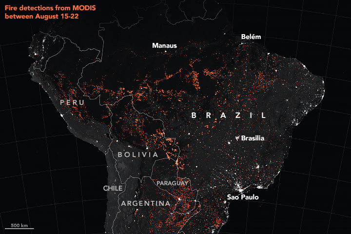
With the fire season in the Amazon approaching its midpoint, scientists using NASA satellites to track fire activity have confirmed an increase in the number and intensity of fires in the Brazilian Amazon in 2019, making it the most active fire year in that region since 2010.
Fire activity in the Amazon varies considerably from year-to-year and month-to-month, driven by changes in economic conditions and climate. August 2019 stands out because it has brought a noticeable increase in large, intense, and persistent fires burning along major roads in the central Brazilian Amazon, explained Douglas Morton, chief of the Biospheric Sciences Laboratory at NASA’s Goddard Space Flight Center. While drought has played a large role in exacerbating fires in the past, the timing and location of fire detections early in the 2019 dry season are more consistent with land clearing than with regional drought.
You can show a map of current fires here:
The latest figures are here, where you can see the big increase in the numbers of fires, and the fire intensity too, in the second half of August - while up to then, as for the previous NASA report it was running at average or below average levels. Note, these are the cumulative fire counts from May rather than the entire year.
. 
So that's the explanation, the fires were at average levels through to mid August, and then there was a huge uptick.
Why was that? Seems that it started when the farmers in the state of Para declared a "'dia do fogo,'" or "day of fire" on August 10th. They said they did this in order to show to Bolsonaro that they want to work and that the only way to clear pastures for them to work was with fire (report in Portuguese here), This was spectacularly "successful" and there was an immediate increase in fires which continued through the following weeks.
As Aljazeerah reports it:
According to the Brazilian newspaper Folha do Progresso, the fires started on August 10 when an association of farmers in the state of Para announced a so-called "day of fire". The idea, according to the publication, was to coordinate a number of simultaneous fires to show Bolsonaro "they are ready to work". On that day, 124 new fires were registered by INPE and the next day 203 more were flagged.
The Public Prosecutor in the State of Para has opened an investigation into the incident
The good news here is that Brazilians are noticing and responding. Bolsonaro is getting massive protests and marches within Brazil as well as international pressure. The black smoke that turned Sao Paolo, turning daytime almost to night at 2 pm really brought it home to Brazilians.
(click to watch on Youtube)Sao Paolo has over 12 million residents, about 6% of the total population of Brazil (200 million or so).. The increased deforestation and fires and the black smoke means that those millions of people are all aware of what is happening in a way that hasn't happened before. The local and worldwide protests about the fires are having an effect similarly to the green wave in Europe for Greta Thunburg.
(click to watch on Youtube)Bolsonaro is responding to this pressure too. He has got the military in, which shows he realizes something has to be done. It's not like he responded "who cares about the forest". Instead he said
"The protection of the forest is our duty. We are aware of it and we are acting to combat the illegal deforestation as well as other criminal activities that put our Amazon at risk"
This is Fox News, Trump's favourite TV network in the US, reporting on it:
Trump also agrees that action is needed urgently to stop this, offering the help from the US to help put out the fires if that is needed. Even though both Bolsonaro and Trump do not think that human induced climate change is happening, this is a point of agreement with the rest of the world. Trump is able to agree with the rest of the world on the value of the Amazon rainforest and importance of protecting it.
France is sending its military to region to help. G7 countries have released $22 million, mainly for planes to drop water on the fires Bolsonaro accepted an offer of support from Israel. And the EU are saying that it's hard to imagine the big trade deal involving south American countries with tge EU to go ahead while Brazil fails to stop the fires. They are also going to be meeting in September to discuss plans to reforest the Amazon.
Amazon fires: G7 to release funds for fire-fighting planes
This is another article I'm writing to support people we help in the Facebook Doomsday Debunked group, that find us because they get scared, sometimes to the point of feeling suicidal about it, by such stories.
Do share this with your friends if you find it useful, as they may be panicking too.
NASA'S STATEMENT ABOUT EARLIER FIRES THROUGH TO MID AUGUST
skip to LOOKING FORWARD
The image they share shows smoke from fires in the Amazon region on 13th August 2019. These are not necessarily all forest fires. Some of these will be fires in natural savannah - or in pasture to stimulate new growth for the cattle. Here it is again with the original NASA caption:
NASA's caption: "As of August 16, 2019, an analysis of NASA satellite data indicated that total fire activity across the Amazon basin this year has been close to the average in comparison to the past 15 years. (The Amazon spreads across Brazil, Peru, Colombia, and parts of other countries.) Though activity appears to be above average in the states of Amazonas and Rondônia, it has so far appeared below average in Mato Grosso and Pará, according to estimates from the Global Fire Emissions Database, a research project that compiles and analyzes NASA data.
There are regions with more fires than usual, especially the Amazonas region. However others have fewer than usual and over the whole region it is about average.
If you go to their cite the Global Fire Emissions Database. this is what you see in the “Totals” section, but this is the cumulative count from January instead of May:
The green line for 2019 there is a bit hard to make out, so here is a zoom in,
as you can see it is way below the top line which is for 2005, with only a few data points, and is also below the 2016 figure. BTW though it says "last updated April 2019" it has data points on it through to late August.
However if we now highlight the 2019 figures in green and the 2016 figure in blue and leave the rest faint you can see the big change in August
Global Fire Emissions Database. t
The green line is rapidly rising, far faster than the fires have ever risen in August in recent years (though there were faster increases a decade ago)..
So, the cumulative fire count from 1st January is still less than for 2016 but if you start the count at 1st May you see a huge uptick in August making it a record. So - it is already a record for the burning season but not for the whole year yet.
LOOKING FORWARD
skip to SOME COMMON MISUNDERSTANDINGS AND URBAN MYTHS ABOUT THE AMAZON RAINFOREST
With Bolsonaro acting to stop the fires I think there is a reasonable chance it stops this rapid increase and if so the end of year stats could well be less than for 2016. If he keeps that up in future years too it can prevent another future "fire day".
It is heartening for me to see ordinary Brazilians protesting and to see him actually acting in response, similar to the green wave here in the UK / Europe
What would be really good would be new emphasis on sustainable use of the land already cleared.
It's quite simple things.Not new technology, we already know how to do it and it is already being done in Brazil in pilot projects that have increased productivity just by replanting the grassland. The right hand field here has been replanted, left hand side not, and this is only one month after planting
The payback time is 5-7 years. This has the potential to free all the land needed for extra agriculture through to 2040 just by increasing the productivity of the existing ranchland from a third of optimum to half of optimum, if somehow it can become easier for farmers to do this rather than to cut down forest. .
See the section RANCHING COULD BE MUCH MORE PRODUCTIVE WITH JUST THE EXISTING LAND (below)
SOME COMMON MISUNDERSTANDINGS AND URBAN MYTHS ABOUT THE AMAZON RAINFOREST
skip to : WILDFIRES PART OF NATURE WORLDWIDE or to SO WHAT HAPPENED - DO WE BELIEVE NASA OR INPE
Before I go into more details, I'd like to briefly touch on a few common misunderstandings and urban myths / outdated science that many believe about the Amazon rainforest. I'll go into in more detail later on.
Many of the fires you see in the photos are not forest fires, and not all forest fires are illegal deforestation
The ranchers use fire for forest clearing, "slash and burn agriculture" as it is called. That is because it is much easier to convert forest into grassland by burning it than to do it by felling the trees. Once it is cut, the way they manage the pastures is to reburn them every few years to clear out the brush and to get the grass to resprout.
So not all the fires you see are burning in virgin tropical rainforest. Many are controlled grassland fires, to get the grass to resprout. We do something similar in the UK where they do controlled burning of heather (muir burn) for grouse, sheep and deer.
It is illegal to start those fires in Brazil during the driest season because though it is the easiest time to burn the grassland the fires can get out of control too easily. But they are not always started with the intention to burn down the tropical forest. It's often just a mistake. The same happens for heather fires in the UK some of our forest fires are due to out of control heather fires.
You can read about how they manage the pastures in Brazil through burning here: Cattle Ranching in the Amazon Region
In Boreal South America, half are forest fires, rest mainly fires which they do every few years to refresh grassland. Nowadays 75% of Amazon forest fires are grassland fires that got out of hand (used to be correlated with deforestation). For details see Changes in Climate and Land Use Over the Amazon Region: Current and Future Variability and Trends.
- The Amazon rainforest will not disappear rapidly once you get below 59% forest cover
This is based on widely misreported research about the fractal process of fragmentation of forests at 59% forest cover. Also there was some research suggested that the rainforest has a "tipping point" where it would rapidly transition to savannah almost everywhere. However these were simplified models with a maximum of two plant functional types and not accounting for ranges of tree sizes and ages, nutrient cycles and other details.
They understand what is going on very well at the leaf level but at the forest level it is hard to model what will happen in response to climate change and deforestation. The climate is already changing because of the deforestation. There were three mega-droughts in 2005, 2010 and 2016, which at the time were classified as a “one-in-100 year event”. Then there were mega floods in 2009, 2012, and 2014.
The deforestation fragmentation can reduce biodiversity by 13–75%, and impair key ecosystem functions by decreasing biomass and altering nutrient cycles.
There are plenty of reasons to stop deforestation and reverse it. But it's no longer clear that there is any particular tipping point where it will all go in a single dieback with several studies finding more resilience than was thought before. More research is needed on what can happen and how to mitigate it. (Again see Changes in Climate and Land Use Over the Amazon Region: Current and Future Variability and Trends.) - I go into this in more detail below.
- We will not all suffocate if the Amazon rainforest is cut down
Many of the news reports talk about the Amazon rainforest being a major source of oxygen. Actually most of it comes from the sea, phytoplankton. But we are not going to suffocate if we burn down forests. This is an urban myth, and science fiction trope, in dustpan futures - but it is not true at all.
We have plenty of oxygen in the atmosphere for thousands of years even if somehow magically all photosynthesis stopped producing oxygen and all the animals continued to use it. See my Debunked: If we cut down all the forests we will run out of oxygen to breathe - they are not the “lungs of the planet” in any literal sense
WILDFIRES PART OF NATURE WORLDWIDE
skip to : SO WHAT HAPPENED - DO WE BELIEVE NASA OR INPE
Nearly all forests have wildfires, naturally, but they are much rarer in tropical rainforests because they are wet year round. The natural fires mainly happen where the forests meet drier pastureland / savannah and in the Amazon region they are driest in July onwards to mid September.
This shows fires from space - if you could take such a video ten million years ago it would still show many fires, though the fires would be started naturally rather than manmade.
(click to watch on Youtube)
This is a short summary from NASA about why we get forest fires in various parts of the world.
(click to watch on Youtube)
For Brazil, most of the fires we get at present are manmade and are started deliberately as the easiest way to remove tropical rainforest in order to convert it to grassland for cattle ranching.
You can see some of the ranching from space in this video at the end.
(click to watch on Youtube)
Sometimes they spread further than intended. This has gone on for many years now and we always have the stories at this time of year about the fires in the Amazon seen from space.
- The burnt areas do not become desert and with global warming the Amazon will not turn into a desert region
It turns, rather, to grassland as the end process over multiple fires. However, if there is a forest fire and it is not immediately followed up by ranching activity to convert it to pasture, the trees regrow quickly, though to a lower biomass forest with only 75% of the carbon. Eventually after repeated burning it becomes savannah - but not desert.
I'll summarize: Amazon fires explained: what are they, why are they so damaging, and how can we stop them?
First, if there is a fire in virgin tropical rainforest then it is just an understory fire and travels slowly. Only 200 to 300 meters a day. Animals and people can get out of the way easily.
(click to watch on Youtube)Frefighters can stop such a fire just by raking out a simple fire break.
However even a low intensity fire like that can kill half the trees, small ones and then larger ones later on, losing more than half the carbon captured in the forest. Eventually they regrow but the resulting forest has 25% less than the previous virgin forst even after three decades. It loses a fair bit of its biodiversity.
After that though the forest is drier and can burn more easily. After it burns a second time the forest is much less diverse and drier and prone to burn over and over every few years. These fires burn the trees right to the treetops killing almost all the trees left. The rainforest birds are gone, replaced by different species that prefer low biomass forests. See Avifaunal Responses to Single and Recurrent Wildfires in Amazonian Forests
Given enough time over many decades and perhaps centuries, these drier forests can restore to tropical rainforest again.
In a warmer world some of them will turn to savannah with scattered trees, similar to the habitat known as the Cerrado, though it won't be as biodiverse forming this way.
- We do not risk losing the Amazon as a whole in any of the climate scenarios through to 2100
That is something they used to think a few years back, that at some future tipping point the entire forest would go, turning to drier savannah. However that was based on simplifying assumptions that turned out to be misleading.
The research has moved on. A large part of the Amazon rainforest will remain through to 2100 even with high emissions, especially the Western Amazon forest. This region survived the previous glacial minimum when it was warmer and will survive any anthropogenic warming through to 2100.
The Amazon as a whole is vast. Even through to 2100 even at high levels of warming the Western Amazon will be largely intact. I cover this later under: SURVIVAL OF LARGE AREAS OF WESTERN AMAZON EVEN AT HIGH LEVELS OF WARMING THROUGH TO 2100
SO WHAT HAPPENED - DO WE BELIEVE NASA OR INPE
skip to : HOW THE NASA FIRE COUNT WORKS
Here INPE is the Brazilian National Institute for Space Research. They run a program called DETER that does rapid assessments of wildfires by satellite. It needs to be validated using PRODES which is yearly and far more accurate. The DETER website says the data should not be relied on.
Ousted Head of Science Agency Criticizes Brazil’s Denial of Deforestation Data
Unicef reports that the data from satellite images show that Brazil lost 2,254 square kilometers (870 square miles) of forest in July, between three and five times the amount lost in the same month for each of the previous four years.
Bolsonaro questions those figures
During a recent public appearance, Bolsonaro joked that if the “absurd” deforestation numbers were true, “then I am Captain Chainsaw!”
Latest deforestation data in Brazil show significant surge - UNICEF.
So what happened? Outside of Brazil everyone is siding with the INPE. But - it turns out on this particular matter, it may be Bolsonaro who is right!
The media reports should never have been leaked to the public without explaining that the science is not validated.
DETER can't see through cloud. It actually has a note on its own page saying it can't be relied on if used in this way. it is for a rapid response, detecting fires early. For that purpose, they do not mind if they detect the same fire multiple times. It is designed as a rapid alert system not a fire count system. When it detects deforestation it has no way of knowing when it happened and may record it for one month when it actually happened years before but the area was covered by cloud and couldn't be spotted earlier.
More details here (in Portuguese).
They differ from the NASA results because they use different satellites and different analysis methods. I'll describe how they work in a bit more detail in the next two sections.
HOW THE NASA FIRE COUNT WORKS
skip to : HOW THE INPE FIRECOUNTS AND DEFORESTATION ESTIMATES WORKS - DETER, QUEIMADAS AND PRODES
This data is based on the Moderate Resolution Imaging Spectrometer , a key instrument on the EOS-AM-1 satellite now known as Terra and the EOS PM-1 satellite now known as Aqua
They are in polar orbits and Terra passes north south over the equator in the morning, and Aqua in the afternoon. Between them they view the entire surface of Earth every 1 to 2 days and acquire data in 36 spectral bands. You can browse their active fire maps here, which detects fires in 1 km pixels that are burning during relatively cloud free conditions.
The project to count the fires is based on a series of papers by Louis Giglio.et al, funded by NASA, and two other organizations. The methods used are explained in the introduction to their article
Here, we present the Global Fire Atlas of individual fires based on a new methodology for identifying the location and timing of fire ignitions and estimating fire size and duration, and daily expansion, fire line length, speed, and direction of spread. The Global Fire Atlas is derived from the Moderate Resolution Imaging Spectroradiometer (MODIS) Collection 6 (Col. 6) burned-area dataset (Giglio et al., 2018), which includes an estimated day-of-burn data layer at a 500 m resolution. Individual fire data were generated starting in 2003, when combined data from the Terra and Aqua satellites began to provide greater burn date certainty. The algorithm for the Global Fire Atlas tracks the daily progression of individual fires at a 500 m resolution to produce a set of metrics on individual fire behavior in standard raster and vector data formats. Together, these Global Fire Atlas data layers provide an unprecedented look at global fire behavior and changes in fire dynamics during 2003–2016.
The Global Fire Atlas of individual fire size, duration, speed and direction
From that paper, they use combined visual and infrared observations. It works best with clear skies, with an uncertainty of one day either way, and as the cloud cover increases there is more and more uncertainty about when the fire started, 5 days either way if clouds cover 75% of the daily scenes and an uncertainty of 20 days or more if only 15% of scenes are cloud free, and no mapping possible at all with higher cloud cover.
HOW THE INPE FIRECOUNTS AND DEFORESTATION ESTIMATES WORKS - DETER, QUEIMADAS AND PRODES
skip to : WORST FIRES IN THE AMAZONAS REGION
The Inpe used to use the Terra and Aqua satellites to estimate the fire count similarly to NASA, see NASA Satellite Data Used by INPE Provides Rapid Analysis of Amazon
However, starting from 2015 they now use much higher resolution satellites, Sino-Brazilian Land Resources Satellite (CBERS-4) part of a mutual scientific cooperation with China, the China–Brazil Earth Resources Satellite program and the Indian Remote Sensing Satellite (IRS). These have a resolution of 64 and 56 meters respectively. The data is aggregated to a minimum size of 6.25 hectares for the general public
This is only meant as an alert system so that the authorities can respond quickly to fires in the region. It is not meant to be used in this way to estimate deforestation or fire counts. It's just not intended for that.
First, DETER is used to estimate the deforestation:
DETER is a quick survey of evidence of changes in forest cover in the Amazon made by INPE. DETER was developed as an alert system to support the supervision and control of deforestation and forest degradation carried out by the Brazilian Institute of Environment and Renewable Natural Resources (IBAMA) and other agencies related to this theme.
For this purpose we use images from the WFI [Wide field] sensors, from the Sino-Brazilian Land Resources Satellite (CBERS-4) and AWiFS [Advanced wide field sensors], from the Indian Remote Sensing Satellite (IRS), with 64 and 56 meters of spatial resolution respectively. Data are sent daily to the Brazilian Institute of Environment and Renewable Natural Resources (IBAMA) without restriction of the minimum mapped area, however, for the general public the polygons are available with a minimum size of 6.25 ha, thus allowing the establishment of a comparison criterion with the data generated by the PRODES project .
...
INPE emphasizes that DETER is an expedient Alert system developed methodologically to support enforcement. Information on areas is for prioritization by enforcement agencies and should not be construed as a monthly deforestation rate. The official INPE number to measure the annual rate of clearcut deforestation in the Brazilian Legal Amazon has been provided since 1988 by the PRODES project.
DETER (using Google auto translate).
The PRODES project is reliable, based on LANDSAT and other satellites comparing before and after images, and shows deforestation for 2018 of 7,536 square kilometers, similar to previous years. However it won't produce the figures for 2019 until next year.
The INPE fire count is on this page, where as of writing it shows 76,729 fires in Brazil so far this year.
As well as the problems with cloudiness, as for DETER, the QUEIMADAS fire count counts focal points. A focal point is just a pixel with fire in it. The pixels can vary from 1 km x 1 km to 5 km x 4 km. A single pixel can have multiple fires in it. Also a large fire can easily overlap into neighbouring pixels and depending where the pixel boundaries are be counted multiple times. Finally, different satellites have the pixel boundaries in different places which can lead to the same fire be counted multiple times as several fires once the data is combined.
It also misses fires that are only on the ground and don't affect the treetops, and fires with a firefront of less than 30 meters, and clouds covering the region (though it can see through clouds of smoke).
It can also miss a fire on a mountain slope if the satellite only saw the other side of it.
Here is their response in the FAQ, which I just paraphrased, I am reading this using Google Translate:
Focus x burn ratio is not straightforward in satellite imagery. A spotlight indicates the existence of fire in an image resolution element (pixel) ranging from 1 km x 1 km to 5 km x 4 km. In this pixel there may be one or several distinct burns that will indicate a single focus. And if a burn is too large, it will be detected on some neighboring pixels, ie multiple outbreaks will be associated with a single large burn. Still, it is common for the same burn to be detected by several satellites. Therefore, maps and tables showing all foci of all satellites will always have some repetitions. Additionally, in many cases, due to the natural variation in pixel size between the various satellites, the same burn can be indicated at locations within a few kilometers depending on the satellite that detected it.
This INPE Burning system detects the occurrence of fire, given by itself extremely important and valid, and necessary for thousands of users of this INPE system. Accurate details of what is burning and how much it burned are information impossible to obtain with current sensors.
Finally, considering the regular mode of detection and using a single satellite as a reference one can observe spatial and temporal trends in fire occurrences.
For details see their FAQ.
See also the Netherlands factchecker site:
- NUcheckt: Facts and falsities about the fires in the Amazon (in dutch, here is the Google Translate)
It is possible that this INPE data is correct and the NASA data is mistaken.
However, given that DETER is not designed to do this job, it seems unlikely. It seems best to wait until the PRODES update for 2019 and then see if the deforested area for 2019 is indeed larger than for 2018.
This is for both the fire count and deforestation figures. There could well be more deforestation going on this year than last year, but it is too soon to know.
The main thing here is that the designers of the DETER and QUEIMADAS tools did not take any precautions to prevent over estimating. Their priority is to get people on the ground quickly to deal with the fire not to estimate deforestation rates.
So when you read stories like this based on DETER
Take that with a big pinch of salt (grain of salt).
It is far too soon to know, we just don't have the scientific data to assess this yet. We will do by the end of the year.
INPE does have reliable deforestation data but it is only up to date to 2018. This is through PRODES which is used to evaluate the level of deforestation at the end of the year using Landsat photographs taken at times when there are few clouds so that the forest can be seen.
Longer term it’s clear deforestation is way down since the 1990s but it is too soon to see if this year will be similar to last year or a return to the levels of the 1990s,.
from Changes in Climate and Land Use Over the Amazon Region: Current and Future Variability and Trends
So - we may see an increase in deforestation in 2019 but we won't know for sure until the next row is added to this table.
WORST FIRES IN THE AMAZONAS REGION
skip to : 40% OF AMAZON IS OUTSIDE BRAZIL
As the NASA page says, the Amazonas region has seen more fires than the average and indeed, it was briefly a record:
And as the NASA page says, although above average also for Rondônia, it has been below average in Mato Grosso and Pará.
The skies over Sao Paulo suddenly became dark in the middle of the day. This is in the largest city in South America
��Just a little alert to the world: the sky randomly turned dark today in São Paulo, and meteorologists believe it’s smoke from the fires burning *thousands* of kilometers away, in Rondônia or Paraguay. Imagine how much has to be burning to create that much smoke(!). SOS�� pic.twitter.com/P1DrCzQO6x
— Shannon Sims (@shannongsims) 20 August 2019
So, it would be equally incorrect to say that nothing is happening in the Amazon at the moment. Especially in the Amazonas region.
The 42 areas of Amazonas officially protected are okay, no deforestation.
For details see Brazil: State of Amazonas declares state of emergency over rising number of forest fires
The state government is also raising farmers' awareness and increasing their presence in at-risk areas in an attempt to curb illegal agricultural fires and discourage deforestation.
40% OF AMAZON IS OUTSIDE BRAZIL
skip to : RANCHING COULD BE MUCH MORE PRODUCTIVE WITH JUST THE EXISTING LAND
Many people probably don't realize that 40% of the Amazonian rainforest is outside of Brazil. Other parts of the forest are much better protected.
An example of a country that has Amazonian rainforest with high protection standards is Suriname, smallest country in South America, and one of the few CARBON NEGATIVE countries absorbing 8.8 million tons of CO2 every year. That's 16 tons of CO2 per year per person.
Photograph from the summit of Mt. Volzburg in Suriname by David Evers
The world average is to emit 5 tons per person per year. So it offsets the CO2 for 1.7 million additional people every year.
RANCHING COULD BE MUCH MORE PRODUCTIVE WITH JUST THE EXISTING LAND
skip to : EFFECTS OF BOLSONARO’S POLICIES
The sad thing is that no forest would need to be burnt for deforestation, if Brazil’s cattle ranching was just a bit more efficient.
I’ll summarize Results from on-the-ground efforts to promote sustainable cattle ranching in the Brazilian Amazon
In the next decade, beef is forecast to grow by 24%, soy by 39% and bioethanol by 27%.
Brazilian beef productivity is currently only a third of its sustainable potential. So much of the land is taken up for ranching that in theory Brazil could meet its entire demand for Beef, crops and timber through to 2040 by increasing its beef productivity from a third to a half of its sustainable potential.
The right side of this photo shows the effect of replanting the grassland to increase productivity, left side is unplanted, and this is only one month after planting
In this pilot study then farms were able to increase productivity by 30–490%
This required an initial investment of US$410–2180/hectare with a payback time of 2.5 to 8.5 years.
But - that's not necessarily easy for a poor farmer in Brazil to do. Loans are expensive and they can default on them.
Changing the structure of financial incentives is key. At present, worldwide, they are in the wrong direction, perverse financial incentives that are encouraging non sustainable practices.
Also top down doesn't work. It needs much more co-ordination between local and government levels as well as between governments than we have today. The ordinary folk and consumers are also part of the transformative change.
It was such a good report in my view far better than the IPCC ones because of the sociological element with expert sociologist which I think is key to really solving this.
Let’s save a million species, and make biodiversity great again - UN report says we know how do it
EFFECTS OF BOLSONARO’S POLICIES
skip to : HOW THE FOREST CHANGES WITH GLOBAL WARMING
Bolsonaro is only in office for four years initially, maximum of two terms at a time, or 8 years (after which he can run again but only after a gap for someone else in office).
Brazilians elected him for his anti-corruption campaign not for his views on the rainforest. Most of the Brazilians actually care about the environment but though most can read and write, few have attained the level of literacy you reach when you leave high school.
Under international pressure he has stayed within the Paris Agreement, and his is a minority government, so he can’t actually reverse the legislation to protect forests, but he is reducing support for enforcing it.
The increased emissions only add a few percent to the CO2 emissions for the year. If all countries had the same emissions as Brazil as it is now, we would not be able to stay within 2°C but so long as others step up their pledges, then it’s mainly important for Brazil to step up its pledges at a later stage and as far as climate change is concerned it's not an immediate disaster.
It does matter for the forest dwellers whose forests are being destroyed right now. But the Amazon forest as a whole is vast and most will not be affected by 8 years of increased deforestation.
HOW THE FOREST CHANGES WITH GLOBAL WARMING
skip to : SURVIVAL OF LARGE AREAS OF WESTERN AMAZON EVEN AT HIGH LEVELS OF WARMING THROUGH TO 2100
Parts of the Amazon rainforest will be lost at 3°C. But these are not lost to a desert. Rather, they transform into a savanna; grassland with scattered bushes. Like the Cerrado:
Composite of these images from Wikimedia commons: Cerrado. :Índios isolados no Acre 5, Ara maca , Emperor Tamarin, Physalaemus nattereri in deimatic behavior
Large areas of Brazil are already Cerrado which has its own rich wildlife.
Also the Amazonian rainforest will not convert to savanna all at once. It is biodiverse and varied and different patches have different species in them. In a warming world at 3°C, some will be more resilient than others and will remain, with a change in the balance of species, while others turn to drier savanna like the Cerrado.
If it was a monoculture the climate would just need to go over some threshold in temperature, or humidity, and the whole thing would go. Because of the mix of species then it is more of a gradual thing. And then because of the patchiness, it would change to grassland only in patches which protects it further.
SURVIVAL OF LARGE AREAS OF WESTERN AMAZON EVEN AT HIGH LEVELS OF WARMING THROUGH TO 2100
skip to : EFFECTS OF WILDFIRES IN THE AMAZON
Parts of the Amazon rainforest seem to be much more resilient, especially the western regions, and this is how it survived previous warm periods. It's now thought most of it would survive this time too.
The upper map here shows the extent of the tropical rainforest and of the lower tree cover areas at the end of the last glacial minimum. This is how the tropical rainforest survives through the warmer periods in the past. The lower figure shows the extent we can expect by 2100.
See this paper in Nature for some of the recent research from 2018:
I am not sure what temperature change the lower one corresponds to. If anyone here is expert and able to say please do. It might be “business as usual?”.
So in short, the composition of parts of it would change. Some might change to a more open drier grassland. However most of it would remain and there would be a lot of tropical rainforest still at 3 °C or even at the higher temperatures of “business as usual”.
Earlier studies didn't take account of the effect of the mix of species some of which are more resistant to heat changes than others. See this paper in Nature from 2016
As the climate warms we do expect more wildfires in the Amazon. But there are fires there every year. They are started deliberately sometimes, for deforestation to open new areas for farming. They also start accidentally due to the trees being drier as a result of draining, they encroach on the forest from nearby open areas. This is an example from 2010:
The line of white trees here are the result of a surface fire encroaching on the Amazon rainforest from an open area during the September 2010 drought.
NASA finds Amazon drought leaves long legacy of damage – Climate Change: Vital Signs of the Planet
EFFECTS OF WILDFIRES IN THE AMAZON
skip to : CRITICAL POINT FOR FOREST FRAGMENTATION
The wildfires in the amazon are mainly started deliberately by humans, as the easiest way to remove tropical rainforest to turn it to grassland for cattle ranching. Sometimes they get out of control and encroach into larger areas of the rainforest. Now however, many fires are also starting in pastureland and then spreading to the forest.
Climate change will lead to the Amazon region getting drier, and wildfires can accelerate that process. First, the forests do recover from wildfire, but full recovery takes a long time.
The initial growth is fast but 31 years later they still recover to only about three quarters of the original biomass. They continue to recover however and long term full recovery is possible. Some trees are centuries to millennia old in mature forests so it’s a long time to replace those.
There are other effects too. For instance burnt forests have a more open canopy, let in more sunlight, and so dry out more. Combine that with more drought conditions and that limits the regrowth. The fires also destroy some of the seedbank needed to reconstitute the rainforest.
Details here:
The other way around, then if unintended wildfires can be stopped, this can help to build in more resilience to climate change.
Increases of fires, e.g. from El Nino’s climate change, logging or road construction can trigger these positive feedbacks leading to a fire dominated lower mass forest.
Some things one could do is to use intensification of cattle ranching in Brazil, and improved soil management in the croplands, so they get the same increases of yields without needing to use fires and clear new forests.
For more on this:
CRITICAL POINT FOR FOREST FRAGMENTATION
skip to : TIPPING POINT AND DIEBACK SCENARIO
This was shared in 2018 with headlines such as
Tropical rainforests may be near a tipping point beyond our control
However it is not accurate to call this a "tipping point" as if the forest would suddenly all disappear and be gone.
What they did is to discover an intriguing fractal distribution of forest fragments. A few large areas, then more medium sized fragments, more smaller ones and so on. This pattern is the same in all forests worldwide despite the many different reasons for felling them and methods of doing it.
This is a timelapse video of deforestation in Rondônia in western Brazil
(click to watch on Youtube)
At exactly 59% forest cover you get patches of forest of all sizes. Above it you get a few large patches, many small patches and not much in between. Below it you get lots of small patches and the largest patches are gone. This is not a die back. It is just the normal patterns of random deforestation breaking it up so that there are no more continuous huge forests. This happened in Europe thousands of years ago. Very few really large forests and nothing remotely the size of the Amazon here. But we still have many forests of intermediate size.
They looked into the causes of it and found that if deforestation exceeds reafforestation it becomes more fragmented. If the other way around it becomes less fragmented. So, you can make a forest less fragmented by slowing down the process of deforestation or increasing reafforestation or both.
They analysed it using percolation theory and found that forest fragmentation is close to the percolation critical point of 59% of forest cover. At a forest cover of 59% then the large scale behaviour has a simple mathematical description. Above or below that it is more complex.
Here you see how it works with their model of the process. To start with there are a few large fragments, many small ones, and none of intermediate size.
At the critical point there are fragments of all sizes following a simple mathematical relationship where the smaller fragments are more common. Below that the largest fragments are gone completely, all broken up into smaller fragments.
To take an example, not from their paper, the UK is clearly in phase 3, much less than 59% is forest. We lost our largest forests thousands of years ago, back when the ancient Britons first introduced agriculture, and are left with much smaller ones. They are still large, just not as vast as the original forests that use to cover our land almost entirely after the last ice age.
Europe, North American and parts of Asia have had more reafforestation than deforestation in the last few centuries, but forest loss exceeds forest gain in most tropical countries.
This is how they see it unfolding along a timeline. Tropical America could reach a maximum of two billion fragments when about three quarters of the forest cover is gone.
This process is under our control. At any time we can change policies to favour reafforestation and then the forests will start to heal and form larger areas again. We can also use such methods as forest corridors to connect together the fragments if it gets to the point where there are no really large areas any more.
They conclude:
Our models predict that additional forest loss will result in a large increase in the total number of forest fragments—at maximum by a factor of 33 over 50 years—as well as a decrease in their size, and that these consequences could be partly mitigated by reforestation and forest protection.
Note - this is a very large scale overview of the situation at a continent level.
For instance, if Brazil was to reach this point where the forest starts to break up into smaller fragments with none of the largest areas left - this would have no effect on Suriname.
TIPPING POINT AND DIEBACK SCENARIO
skip to : FERTILIZATION EFFECTS OF WILDFIRES
The suggestion in some papers is that if another 5% of the Amazon forests are cut down they reach a tipping point beyond which restoring the Amazon is impossible - LATEST RESEARCH SUGGESTS MORE OF A CONTINUOUS PROCESS
Short summary:
The balance of research is more in the direction of a continuous change rather than a tipping point beyond which you can't restore the Amazon. The older research used simple models with only two plant functional types and not accounting for details like a range of tree ages and nutrients and other details. More recent models with more diversity of vegetation find it more resilient and likely to change in patches rather than all at once. The Amazon has also survived much drier conditions in the past, though not identical in all respects.
It also depends on the CO2 fertilization effect and how much this is increasing the biomass of the forests. Although a mass dieback is not looking likely it is 100 times less expensive to act to prevent it using no regrets measures that help anyway. See
Details:
The 2014 IPCC review found that the likelihood of a climate-driven forest dieback is lower than prviously thought.
Since the last assessment report of the IPCC (AR4), our understanding of the potential of a large-scale, climate-driven, self-reinforcing transition of Amazon forests to a dry stable state (known as the Amazon “forest dieback”) has improved. Modelling studies indicate that the likelihood of a climate-driven forest dieback by 2100 is lower than previously thought, although lower rainfall and more severe drought is expected in the eastern Amazon. There is now medium confidence that climate change alone (that is, through changes in the climate envelope, without invoking fire and land use) will not drive large-scale forest loss by 2100 although shifts to drier forest types are predicted in the eastern Amazon.
Though they go on to say that severe drought combined with land use changes and fire can work together to lead to this transition:
There is now medium confidence that severe drought episodes, land use, and fire interact synergistically to drive the transition of mature Amazon forests to low-biomass, low-statured fire-adapted woody vegetation.
The Royal Society review of research from 2017 - says that though some research still emphasizes the possibility of a climate threshold, the balance of recent research is more in the direction of a significant transition - but not a uniform one and in a continuous rather than tipping point type fashion:
Amazon rainforest: The processes acting on tropical rainforests are very complex and a recent review still emphasised the possibility of a climate threshold … Recent work using a detailed ecosystem model (Levine et al., 2016) supports the possibility of a significant but heterogeneous [not uniform] transition in biomass type dependent on the length of the dry season, but in a continuous rather than “tipping point” manner. Resilience may be underestimated if plant trait diversity is not included in models
At present the Amazon forests are increasing in biomass.
'In the Amazon, we’ve found that the forests seem to be increasing in biomass; we think this might be a response to the carbon dioxide in the atmosphere. This has a modest impact on reducing carbon dioxide in the atmosphere and the rate of global warming.
I'd say the best case scenario is where there is still ongoing social and economic development in the tropics, and there is an improvement in people's livelihood, but it's done in a way that maintains large areas of intact and functional forests which provide a home to what is over half of the Earth’s biodiversity. I see there are some countries where, if we can get the governance in place and link it into the science, the tropical forests have a decent chance of surviving. So if you asked me about the future of the Amazon, I’d say there are challenges there, but I’d be optimistic. Climate change is a threat, but if it's not hugely disturbed, or disturbed in a careful way, the Amazon can be resilient to the changes it faces.
Let’s look at the section: The Tipping Point and Die Back Scenario in the Amazon Region, Projections and Uncertainties in the 2018 review article
- Changes in Climate and Land Use Over the Amazon Region: Current and Future Variability and Trends by Marengo et al in "Frontiers in Earth Science"
From this article:
Early research suggested a risk that at a certain "Tipping point" most of the rainforest transitions to savannah. This could be due to
- A critical warming threshold OR
- Deforestation exceeding a certain percentage (varies from 25% to 40% depending on the author) - today we have reached 20% deforestation.
Once it transforms to savannah the soil continues to dry and lose carbon.
These dieback projections were based a simplified representation of the forest biodiversity with a maximum of two plant functional types and not accounting for ranges of tree sizes and ages, nutrient cycles and other details
The Western Amazon is too wet to convert to a dry Savannah, but with global warming there is a possibility of dieback it the Eastern Amazon where the processes of deforestation are increased as the remaining forest dries up.
Some of the effects of climate change are
- Reductions in evapotranspiration because the stomata close at higher CO2 levels and water is used more efficiently
- Increasing runoff and the ground taking up more direct heat leading to increased warming locally, reduced humidity and reduced fraction of low cloud
- Increases in leaf area
- Increase in photosynthetic rate as a result of the stomatal closure and increased water efficiency
There are still large uncertainties because of limitations in our knowledge vegetation responses to increases in CO2 concentration in the atmosphere and changes of climate. They are well understood at the leaf scale but not well understood when scaled up to ecosystems. Then there are many uncertainties about the effects of drought stress,avilability of nutrients, and the diversity and age of the vegetation.
Also it's not known whether the increased photosynthetic rates in a warmer world will continue to increase the biomass. Some species may be better adapted to future environments which is likely to affect the future vegetation composition.
Although the more detailed studies no longer suggest a sudden transition, the uncertainties are still very high. Acting now to prevent a dieback is 100 times cheaper than risking a mass forest die off.
The authors conclude their paper
While science can still advance further in this area, we have also assembled enough knowledge to underline the global and regional importance of an intact Amazon region, in order to support policymaking and to keep this sensitive ecosystem functioning. This major challenge requires substantial resources and strategic cross-national planning, and a unique blend of expertise and capacities established in Amazon countries and from international collaboration.
Changes in Climate and Land Use Over the Amazon Region: Current and Future Variability and Trends
FERTILIZATION EFFECTS OF WILDFIRES
skip to : WORST CASE FUTURES GENERALLY
Actually forest fires have a fertilizing effect on the oceans and on other forests. The forest fires in Africa help the Amazon rainforest to flourish. They used to think it was the Sahara dust but it now seems to be the forest fires in Africa.
African smoke is fertilizing Amazon rainforest and oceans, new study finds
WORST CASE FUTURES GENERALLY
skip to : NOT LIKELY TO REACH 3°C
For other things that will happen as we warm up and the worst case future if we are not able to reduce the temperature below 3 C by 2100 see
NOT LIKELY TO REACH 3°C
skip to : WHY DID BRAZIL ELECT BOLSONARO?
At least as things are going now, it is not likely to go as far as that. We have already knocked a degree off the projection for 2100 from 2015. Though there are the notable exceptions of Brazil, the US, and Canada (and perhaps Australia), more countries than not are keeping to their pledges and expected to increase on them.
It is very promising that we increase on our pledges in 2020, several countries like the UK already have, California is committed to carbon zero by 2045, and China has said it will increase its pledges and map out a way to carbon zero later in this century. Not only that, also it will support the green climate fund, which makes a big difference. It is hugely underfunded, only a fraction of the $100 billion a year that is needed and many of the less developed countries like India will be able to do much more ambitious pledges with funding to support them.
Many forget that the Paris agreement pledges were never expected to lead to a commitment to 1.5 or 2 C in one go. The idea is to increase the pledges. Also CO2 emissions, even yearly emissions are expected to be level or increase through to the early 2020s on all scenarios. The aim is to reach 1.5 C by increasing pledges in 2020 based on the experiences of what worked in the last 5 years (along with improvements in technology and new industries). Then based on experiences from 2020 to 2025, to increase pledges again in 2025 and so on.
See my
For some recent positive news:
- Ethiopians collaborate to plant 353 million trees in twelve hours - world record - aim is to plant 40 trees each this summer for a total of 4 billion trees - can we follow their example in the UK and elsewhere?
- China to Increase 2015 Climate Pledges in 2020, Support Green Climate fund- Maintain Biodiversity&May Peak Emissions Early 2020s
- Ursula von der Leyen’s proposed green new deal will make Western Europe the first 1.5°C compatible continent if passed
And all the Democrats running as candidates for 2020 have a strong green agenda. Even if Trump is re-elected, he may well be influenced eventually by public pressure especially if the green vote clearly has impacted on the Republican poll results in crucial states (example, if they lost Florida due to a green vote). The US needs to come on board by the next pledge in 2025 or at least, by 2030 for best chance of success, but the US emissions are level or falling as the long term trend anyway (with an up tick last year because of more winter heating) so they are not a priority right now in the world as a whole.
WHY DID BRAZIL ELECT BOLSONARO?
skip to : SEE ALSO
Bolsonaro’s government is only in power for four years and it depends a lot on what happens after that. He is a minority government and he can’t remove the legislation to protect the forests, just remove funding and support for those who do protect it. He is also under a lot of international pressure.
More Brazilians care about the environment than not, and he wasn't elected particularly for his environmental views. This author from Brazil says that the public can put pressure on him and also says there is an issue of environmental illiteracy in Brazil
Do Brazilians Really Care about the Environment?
He was elected to fight corruption and also as a result of viral campaigns on social media, not because of his views on the rainforest.
Various speculations here about why he was elected, I can't really comment on them.
[CORRECTION - HAD A SECTION HERE ABOUT BOLSONARO GETING ELECTED DUE TO LOW LEVELS OF LITERACY BUT THAT IS NOT TRUE, THOSE IN HIGHER EDUCATION VOTED MOST FOR HIM AND THOSE WITH LOWEST LEVELS, LEAST - SEE LINKED PAGE FOR DETAILS]
Why did Brazil elect Jair Bolsonaro?
According to climate tracker if all countries followed Brazil’s approach, warming would reach over 2°C and up to 3°C. But of course most countries are not following his approach.
Brazil | Climate Action Tracker
"If deforestation rates in the Brazilian Amazon were to return to the 2004 peak, a likely scenario under Bolsonaro’s rule, it could boost annual emissions to almost 3 billion metric tons over his term, at the top end of that range. That’s nearly half the United States’ total annual greenhouse-gas emissions" Brazil’s presidential election could mean billions of tons of additional greenhouse gases
That would make it so Brazil contributes up to 7% of total CO2 emissions by the table here
List of countries by carbon dioxide emissions - Wikipedia
Another study looked at the absolute worse case where he left the Paris agreement, as he originally planned to do.
"A study by scientists at Brazil’s National Institute for Space Research found that additional emissions could be even higher. They estimated that Amazon deforestation rates could triple, reaching 25,600 square kilometers a year, if Brazil exited the Paris climate deal, authorized mining on indigenous lands, and enacted other policies Bolsonaro has floated." Brazil’s presidential election could mean billions of tons of additional greenhouse gases
would take it to 21% of total world CO2 emissions approx.
- but that's not happening, he hasn't exited the Paris agreement and as a minority government it's not going to be easy for him to enact controversial policies. Can turn a blind eye, can't change the regulation.
It's major especially when there's a priority to cut back rapidly to stay within 1.5 C.
However Brazil is very dependent on exports and other countries can put pressure on it to adopt more green policies. That is probably one of the main factors that has kept them within the Paris agreement.
If we get increasing awareness of green issues in the Brazilian population - it is possible they can influence him if they find a voice and if there is more awareness of such issues there.
See also my
SEE ALSO
back to top
See also my
There is a lot positive going on. See for instance my
If you want to hear some happy news for a change, then the Happy Eco News blog may help.
See also my
- No Scientific Cliff Edge Of 12 Years To Save Planet (or 18 Months) - Can IPCC Challenge 'Deadlines Make Headlines' Misreporting?
- Positive side of climate change facts, after two years of action, heading for 3°C with 1.5°C well within reach
- Let’s save a million species, and make biodiversity great again - UN report says we know how do it
- Yes our generation’s children are headed for a world with nature and wonder in it - and their children too
- Rising Seas - Ingenious Ways Netherlands, Florida And Bangladesh Can Adapt - Barriers And Sponges - And Floating Gardens
Doomsday Debunked
Seven tips for dealing with doomsday fears
If you are scared: Seven tips for dealing with doomsday fears which also talks about health professionals and how they can help.
If in the middle of a panic attack, see
- Breathe in and out slowly and deeply to calm a panic attack by Robert Walker on Debunking Doomsday
- Tips from CBT - might help some of you to deal with doomsday anxieties
- STOPP skill
Useful links to bookmark
- Search Doomsday Debunked (Facebook)
- Search Debunking Doomsday
- List of debunks
- Search Quora for articles by 'robert walker' (insert whoever you want to search for)
- Search Sites rated Very High for Factual
- Search Doomsday Debunked Wiki
Tip, bookmark those links to search for debunks more easily. Here is a screenshot of my bookmarks
Facebook support group
Facebook group Doomsday Debunked has been set up to help anyone who is scared by these fake doomsdays.
If you need help
Do message me on Quora or PM me on Facebook if you need help.
There are many others in the group who are available to support scared people via PM and who can also debunk fake Doomsday “news” for you if you get scared of a story and are not sure if it is true. See our debunkers list
If you are suicidal don’t forget there’s always help a phone call away with the List of suicide crisis lines - Wikipedia
Our petitions
- To Google, Apple and Facebook - please stop promoting fake red top tabloid news
- To Journalists: Debunk Rather than Dramatize "Doomsday" Stories - Vulnerable Get Suicidal
- To YouTube : Halt Ads on Doomsday Videos


_(9714001143).jpg)
Comments