A team of Portuguese researchers have developed amathematical tool that can classify any region in the world according to itspattern of development into one of 5 types - each with specific characteristicsand predictable behaviours - that call for different interventions and policymeasures. The discovery, just out inNature’s Scientific Reports, representsa major step towards a new type of city planning - objective and, mostimportantly, independent of the personalvisions, interests and ever changing politics .
Jorge M. Pacheco, one of the scientists involved in the studyexplains “what this means is that now wefinally could have a unified characterisation of urban areas worldwide thatpave the way for city planners all over the world to collaborate, whethercomparing urban policies or forecasting typical future scenarios and proceduresto deal with them.”
“And the software that does all this “says Pacheco “ is not only effective, but also easy to use, can assessany region in the world and be run in any computer. All we need is people’s interest; thetechnology is free and is here. ”
The logic behind the development of our cities is, to anyonethat ever lived in one, a mysterious affair. Like living organisms, buildings grow fuelled by the desires and viewsof the individuals that live and rule in the cities. An objective approach tourban development has been needed for a long time but is now more urgent thanever with the rapid growth of cities in countries with fast economical growth likeIndia and China, where too often cement jungles are destroying people’s lives.
In the work now published, Sara Encarnação, Jorge M. Pachecoand colleagues from the ATP-Group at the Institute for InterdisciplinaryResearch and the Centre for Geographical Studies and Regional Planning, at the NOVAUniversity, both in Lisbon, use as case study the Metropolitan Area of Lisbon(MAL) or “Big Lisbon” - which includes the city, as well as its growing suburbsand a ring of rural regions.
Then from information on the urban development of MAL in three different years - 1960, 1990and 2004 – they develop a mathematical model that classifies cities based notonly on the amount of built up, but –and here is the interesting part - also on how built-up is distributed (so where are thebuildings) and how dense or fragmented is the spatial patterning of thecity, as well as how these vary withtime.
And whatthey found is 5 very distinct Types of development, each with specific characteristicsand, even more interesting, predictable behaviours. These go from Type 1, wherebuilt-up areas are scarce and isolated, and land is used mostly for agricultureand forest, to Type 5, where building is close to saturation and the space fornew constructions is rare.
To city planners, however, Type 3 and 4 are the ones of realinterest. These are regions with plentyof free land where to built, but also a space distribution that allows manydifferent ways to arrange what is built. And here is where their problem lays -the combination of space to build and possibilities to arrange the built-up, putsthese regions at the highest risk of uncontrolled (chaotic) growth.
Additionally, Type 3 regions typically grow by forming newdispersed built-up areas, which are linked to urban sprawl (the rapid expansionof urban areas known to bring planning, social and even health issues). Type 4areas, on the other hand, develop by consolidating existing constructions intolarge connected urban block making them, despite still problematic, much less than Type 3 regions.
But the question with all theoretical models is how well they describe (and predict) real events. To test this the researchers went back to MAL and after calculating theType of each Km2 of territory and giving each of the 5 Types a distinct colour, plotted the results in the maps. By “typing” each Km2 they will obtain a highly detailed image of what is happening.
Figure 1 shows the results
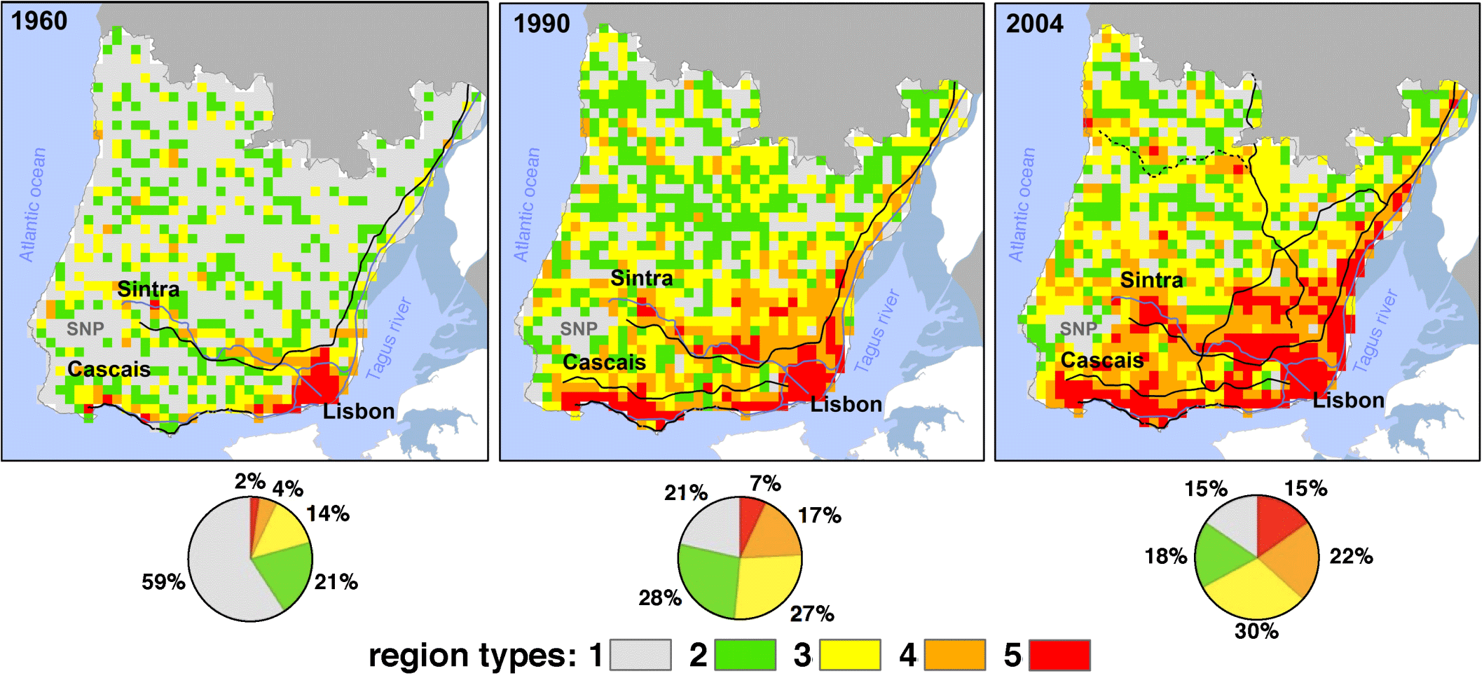
Fig1
What they discover is a remarkable agreement between what themodel predicts and what planners known about MAL development throughout theyears. For example, several spots of Type 3 (yellow) and 4 (orange) areasdetected in 1990 (that by 2004 show huge growth) are regions known to have gonethrough uncontrolled housing due to lack of effective regulation, and that nowhave huge urbanisation and social problems
Even more important, the model provides warnings; in 2004 itis already possible to spot, next to a new road in the northern periphery ofLisbon, several Type 3 areas, which, if left without regulation, will no doubtbe at risk of yet more chaotic development.
Throughout history, cities tend to move from Type 1 to Type 5(as D increases), but it is how they get from one to the other that determinestheir inhabitants quality of life. Encarnação and Pacheco’s work reveals that metropolitan areas behavelike living evolving organisms that need effective, but also flexible planningand regulation.
By developing a way to classify what is happening as it ishappening, uncovering in real time those areas requiring more attentionEncarnação and Pacheco’s model brings this flexibility.
Pacheco adds “Now imagine a Google map with a version of the world in which every patch of land will be cartographically identified accordingto the model, and you can see how much easier and quicker would be to make the right planning decisions”
(for a version with more detail on the science behind the discovery see __http://www.science20.com/catarina_amorim/new_software_can_radically_change_city_planning_worldwide_and_free-93123
Original article
Scientific Reports , 2, Article number: 527 doi:10.1038/srep00527“Fractal cartography of urban areas” by Sara Encarnação,Marcos Gaudiano,Francisco C.Santos, José A. Tenedório& Jorge M. Pacheco
http://www.nature.com/srep/2012/120724/srep00527/full/srep00527.html (open access)