


Phragmites australis is an invasive species of plant called common reed that grows rapidly into dense stands of tall plants and then pose an extreme threat to Great Lakes coastal wetlands.
a GROUP FROM Michigan Technological University', the US Geological Survey (USGS), Boston College and the US Fish and Wildlife Service (USFWS). have mapped the coastline of all five U.S. Great Lakes using satellite technologies and, combined with field studies along those coastlines to confirm the satellite data, their map shows the locations of large stands of the invasive Phragmites located within 6.2 miles of the water's edge.
The Phragmites map is the first of its kind. Lead author Laura Bourgeau-Chavez, a research scientist at MTRI in Ann Arbor, Mich., calls it "a highly accurate data set that will allow national, regional and local managers to visualize the extent of Phragmites invasion in the Great Lakes and strategically plan efforts to manage existing populations and minimize new colonization."
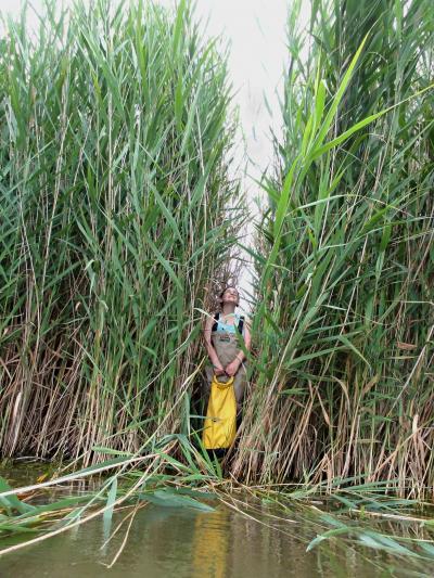
5-foot-tall Naomi Hamermesh is dwarfed by a stand of Phragmites. Credit: Michigan Technological University
Why is invasive Phragmites such a threat? The invasive form can out-compete native wetland plants for resources, quickly dominating wetlands. It displaces native vegetation and reduces the quality of the habitat, the scientists say, altering nutrients in the soil and water, decreasing the diversity of animals and plants that normally live there, increasing air temperatures, drying wetland soils and trapping sediments. Mature stands of Phragmites often reach 16-feet tall, interfering with shoreline views, which can lower property values.
Using synthetic aperture radar (SAR), the researchers were able to use the longer wavelengths of SAR (approximately 23 centimeters) to distinguish between high biomass invasive Phragmites and other types of wetland vegetation. It also helped them detect flooding under a canopy of plants. For the entire Great Lakes basin, the overall accuracy of the resulting map was 87 percent.
To validate their classification of the satellite data, similar information was collected by hand at random sites throughout the coastal wetlands of the Great Lakes during 2010 and 2011. By the end of 2011, a total of almost 1,200 half-acre field sites had been checked.
Lakes Huron and Erie turned out to have the greatest amount of invasive Phragmites. The project identified a smaller extent of Phragmites in Lake Michigan but only a few stands in Lake Ontario and almost none in Lake Superior.
Although other factors may be at play, it appears that climate is helping determine the northward range of Phragmites. Changing climate conditions, therefore, may have broad impacts on the distribution of Phragmites. With the developed dataset, scientists can effectively model future range extension and target control efforts. The methods developed in the project can also be used to re-map targeted areas in the future.
The Canadian coastlines of the Great Lakes were not included in this study due to financial constraints. In the future, the researchers hope to extend their mapping to the Canadian shores and further into the landscape than the current 6.2 miles.
Published in the Journal of Great Lakes Research.


Comments