

I am trying to explain in this series the most important aspects of the sciences most relevant to climate as a cross-disciplinary study. My intention is to help my readers to build up a sort of 'mental model' of the most important components of the earth's climate sytems.
The first parts covered mainly astronomical considerations: axial tilt, orbital eccentricity and solar variation, for example.
I now turn to the topic of hypsography.
New readers may wish to start at Understanding Climate : #1 - Components Of Climate.
--------------------------
Hypsography
If the earth's surface were all land, or all sea, without differences of height and depth, our planet would be much different. In fact, if there were no mountains, no rifts, no valleys, nothing but a smooth rock surface, that surface would lie underneath about 4 kilometers of water.
Hypsography is the study of the distribution of land by height and sea by depth. The topic of ocean depth - bathymetry - is often treated as a separate field of study. I include it here because it is of great relevance to the understanding of climate. I also include here, under the same heading, the geographical distribution of land. Hypsography, as I use the term here, is the study of the statistical distributions of geographic physical features - a branch of physiography, or physical geography. These statistical distributions have an important - and often overlooked - impact on the global climate systems.
The earth, in its motion through space, is subjected to various amounts of sunshine and to varying ratios of day to night at various latitudes. The distribution of the sun's warmth depends mainly, but not entirely on the way that the angle of insolation varies with latitude. The areas where the sun is more nearly overhead receive most warmth, areas further North or South receive less warmth. In Arctic winter, which corresponds with Antarctic summer, the Arctic is in constant darkness and the Antarctic is in constant sunshine. Six months later, matters are reversed: the Antarctic is in constant darkness and the Arctic is in constant sunshine.
Land distribution by latitude
If every zone of latitude had the same ratio of land to sea, then places at the same latitude, North or South, might be expected to have broadly similar climates. One reason that they often do not is explained by the global distribution of land and sea.
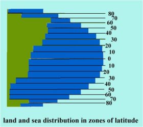
This - admittedly rough - graphic shows at a glance the approximate amounts and ratios of land and sea in various zones of latitude. Land absorbs heat and loses it faster than water. During the course of any average day, if a zone of latitude has more water than land then it will tend to be warmer than otherwise. But days are not average across the globe.
During the long Antarctic night, even though precipitation levels are low, the ice sheet grows. Unlike the Arctic ice sheet it is not subjected to constant agitation by wind, tides and waves. It just sits there and grows. And grows colder. For as long as the Antarctic continues to grow in winter and melt in summer, the southern oceans will be cold. The weaker insolation due to the sun's low angle, coupled with the intense Antarctic cold, over-ride the tendency for oceans to warm up. Even though there is vastly more ocean than land, the little land that there is hardly benefits from being coastal.
Moving away from the southern ocean and into the Pacific, especially in tropical latitudes a different picture presents itself. The oceans, especially the Pacific, during the long days of summer can absorb vast amounts of heat, more heat than is lost by night. This happens because there is significantly more ocean than land. Land loses heat rapidly by night. Any heat gain by land during summer is entirely trivial compared to ocean heat gain. That heat store, if globally shared through various mechanisms to be discussed under oceanography, moderates the global climate, together with polar ice, keeping temperatures within a fairly narrow range. Unless that global heat regulation system fails for some reason.
In Northern latitudes, as far North as 70o there is an ever lower ocean to land ratio. The graphic clearly shows the difference between the Northern and Southern hemispheres in terms of geographic distribution of land. That difference explains to a great degree why Northern hemisphere summers are cooler on average than Southern summers. There is more land, which fails to store heat in summer, and there is less ocean to release its heat in winter.
The Arctic is almost all ocean. Indeed, from about 85o North it is all ocean. If the Arctic ocean was not capped by ice it would act as a heat store in summer, releasing its heat so as to moderate the cold of the long Arctic nights. Ice perfoms three functions in moderating the global climate. As it is a fairly good insulator, during winter it prevents heat radiation into the air from the waters it covers. During summer, it melts to a greater or lesser degree, thus absorbing solar energy which would otherwise warm the sea. In all hours of daylight the ice reflects sunshine, thus reducing the sun's heating effect. The role of ice in climate science will be covered more fully in a future article.
Land distribution by longitude
At the time of Pangaea, most of the earth's land was in a single mass, spread out fairly evenly from North to South. This must have had a dramatic effect on climate. In all zones of latitude a vast expanse of ocean would have acted as a thermal reservoir, moderating the coastal climate globally. Towards the centre of the land mass and away from any inland sea or lake, the climate would have been extremely arid. That is due to the mechanism by which moisture in the atmosphere from ocean evaporation tends to precipitate over land, especially over hills and mountains. The further an air mass is from a coast, the drier it is likely to be.
Before Pangea formed, the separate plates were bounded by oceans. Each plate accordingly had its own climate system. Paleogeology suggests an abundance of life in shallow waters and land of the areas with coastal climates. As Pangea came together these shallow seas would have soon become landlocked. As the local climate became more arid, evaporation would have exceeded precipitation. The seas were drying up. A combination of volcanic activity and climate change would have caused anoxia in these waters, followed by emissions of noxious gases.
By the time Pangea had finished forming, about 250 million years ago, 57% of all families and 83% of all genera went extinct. In plainer language: about 90% of all living species died out. Climate change was one of the factors in this, the greatest known extinction event - the Triassic_extinction_event.
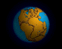
Pangea.
In the next part of this series I shall continue the theme of hypsometry with a discussion of how the heights and depths of geographic features affect climate, both locally and globally.
----------------------------------------
Further reading:
Mother Earth Cycles To Work
The Earth: A System Of Dynamic Equilibrium
Runaway Greenhouse Effect: Purple Bacteria
Runaway Greenhouse Effect and Carbon Dioxide
Pangea introductory reading:
http://geology.rutgers.edu/103web/Pangeabreakup/breakupframe.html
Extinction, John Baez, April 8, 2006
http://math.ucr.edu/home/baez/extinction/


Comments