


Learning about ancient civilizations used to mean hand-drawn maps and clunky tomes; now anyone can do it, using Google Earth and some idea of where to look and what to look for.
And Google Earth has helped create a map of an ancient Syrian trade route that shows how one city's political sway extended farther than believed. It still takes old-fashioned digging by others to have found the artifacts in the first place, but for visualization and understanding, the future is here.
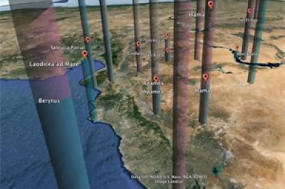
"I trace the process of change by working with historical proxies, in this case coins," says Kristina Neumann, a doctoral candidate in history at the University of Cincinnati. "I created my own database from previously published excavation reports and lists of coin hoards, and imported it to Google Earth. My criteria are so detailed that I can see all the coins for a particular emperor or of a particular material."
Neumann can zoom along the boundaries of ancient Antioch during the beginning of Roman takeover and see how its political sway extended farther than once thought. She hopes this visual, interactive way of presenting the ancient world inspires other historians to get more creative in today's "there's an app for that" world.

Credit: Kristina Neumann, University of Cincinnati
In ancient times, much like now, authorities determined which foreign currency was accepted in a community. For Neumann, this made coins an ideal representation of a political relationship among cities. For example, if lots of Antiochene coins were discovered in a neighboring city, it's likely a political agreement existed between the two governments.
Coins were also a data-rich resource for Neumann. In addition to tracking where the coins were found, she cataloged critical information about a coin – such as when it was minted and under whose authority it was made – that has been derived from the images and inscriptions imprinted on it. Other artifacts, like pottery, were less likely to have such identifiers.
Neumann uses Google Earth to convert the vast information in her coin database into a visual representation of Antioch's political borders. She analyzes how the software plots which coins were found where and in what quantity across different historic time periods. This way she can follow the transformation of Antioch's political influence as it was absorbed by the Roman empire.
She has found Antioch's civic coins were spread farther out than previously theorized, and they were particularly abundant along a known trade route. Neumann can scan centuries of change in seconds with Google Earth to show the overall contraction of Antioch's political authority but also its continued and evolving influence in selected regions and cities – and eventually its greater integration within the empire.
Credit: Kristina Neumann, University of Cincinnati
"I'm very interested in the idea of empire – physical empires, but also empires similar to what America has with its cultural and informational empires, and the idea of globalization," Neumann says. "My bigger question is, 'How do you get one empire which absorbs a lot of different people and yet lasts so long? How is stability achieved even with vast diversity?' I think that can speak to today's society with the culture changes we're seeing."
Neumann will present her research "Using Google Earth to Visualize an Ancient City's Influence: Roman Antioch" at the Archaeological Institute of America and American Philological Association Joint Annual Meeting this week in Chicago.


Comments