Boulder, Colo., USA: The most studied battleground from the American Civil War, from a geological perspective, is the rolling terrain surrounding Gettysburg, Pennsylvania. Here, the mixture of harder igneous and softer sedimentary rocks produced famous landform features such as Cemetery Hill and Little Round Top that provided strong defensive positions for the Union Army.
Another even more common type of rock -- carbonates such as limestone -- provided similarly formidable defensive positions at numerous other battlefields in both the eastern and western theaters of conflict.
Limestones and dolostones shaped the terrain of multiple important battle sites, including Antietam, Stones River, Chickamauga, Franklin, Nashville, and Monocacy, and these rock types proved consequential with respect to the tactics employed by both Union and Confederate commanders.
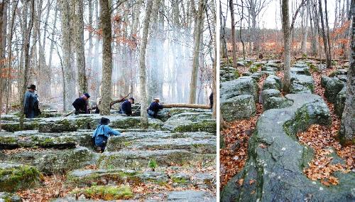
This article by Scott P. Hippensteel of the University of North Carolina at Charlotte describes how carbonate rocks produced rolling terrain that limited the range and effectiveness of both artillery and small arms. Additionally, thin soils above limestone bedrock prevented tillage and the resulting forests provided concealment and cover for advancing troops. From a defensive perspective, on a larger geographic scale carbonates provided natural high ground from chert-enriched limestones. On a smaller scale, erosion of these same rocks produced karrens (or "cutters") that provided natural rock-lined trenches for defending troops.
FEATURED ARTICLE
Carbonate rocks and American Civil War infantry tactics
Scott P. Hippensteel, Department of Geography and Earth Sciences, University of North Carolina at Charlotte, 9201 University City Boulevard, Charlotte, North Carolina 28223, USA. Themed issue: Human Dimensions in Geoscience. This article is online at http://geosphere.gsapubs.org/content/early/2016/03/16/GES01266.1.abstract.
All GEOSPHERE articles are available at http://geosphere.gsapubs.org/. Representatives of the media may obtain complimentary copies of GEOSPHERE articles by contacting Kea Giles at the address above. Please discuss articles of interest with the authors before publishing stories on their work, and please make reference to GEOSPHERE in articles published. Non-media requests for articles may be directed to GSA Sales and Service, gsaservice@geosociety.org.
Assembling the world's type shallow subduction complex: Detrital zircon geochronologic constraints on the origin of the Nacimiento block, central California Coast Ranges
Alan D. Chapman et al., Department of Geological Sciences, Stanford University, Stanford, California 94305, USA and Geology Department, Macalester College, St. Paul, Minnesota 55105, USA. This article is online at http://geosphere.gsapubs.org/content/early/2016/02/29/GES01257.1.abstract.
This paper aims to evaluate two longstanding models for the origin of the Nacimiento block, an approximately 10,000 square kilometer belt of ~100 to 80 million year old subduction-related rocks exposed in the central California Coast Ranges that is clearly out of place relative to other rocks in central California. These models include: (1) the Nacimiento block originated west of the Mojave Desert and was displaced ~300 km northward from this location when the San Andreas fault became active and (2) the Nacimiento block originated west of the San Francisco Bay Area and moved ~500 km to the south before being displaced to its current position by San Andreas fault activity. To test these models, we compared the abundances of zircon ages (a technique known as detrital zircon geochronology) in rocks of the Nacimiento block, the San Francisco Bay Area, and the Mojave Desert to determine if rocks of central or southern California represent a better "match" to rocks found in the Nacimiento block. We conclude that zircon age populations in the Mojave Desert, and not the San Francisco Bay Area, provide a better match to those found in the Nacimiento block. Hence, our results are more compatible with model 1 than 2. This result is helpful for piecing together the tectonic jigsaw puzzle of California and for improving our understanding of how subduction-related processes shaped the western margin of North America.
Composition of sediment records late Quaternary paleogeographic evolution of Santa Clara Valley, California
David W. Andersen et al., Department of Geology, San José State University, 1 Washington Square, San José, California 95192, USA. Themed issue: A New Three-Dimensional Look at the Geology, Geophysics, and Hydrology of the Santa Clara ("Silicon") Valley. This article is online at http://geosphere.gsapubs.org/content/early/2016/02/29/GES01259.1.abstract.
Gravel and sand samples from five wells in the Santa Clara Valley, California, contain minerals showing that sediment from the Santa Cruz Mountains south and west of the valley spread as far northeast as Coyote Creek and the Guadalupe River for at least the last 800,000 years. This information will help constrain the geometry of aquifers and confining layers within the groundwater basin in the valley, and it may suggest that active faults along the northeast side of the valley have contributed to the valley's topographic asymmetry for this entire time.
Sources of volcanic detritus in the basal Chinle Formation, southwestern Laurentia, and implications for the Early Mesozoic magmatic arc
N.R. Riggs et al., School of Earth Sciences and Environmental Sustainability, Northern Arizona University, Flagstaff, Arizona 86011, USA.
This article is online at http://geosphere.gsapubs.org/content/early/2016/03/09/GES01238.1.abstract.
Approximately 270 million years ago, subduction began off the west coast of North America, forming volcanoes and the associated intrusive bodies. Over time these volcanoes eroded, and a large sedimentary basin, called the Chinle Formation, formed to the east of the volcanic arc, in what is now southern Nevada, northern Arizona, and southern Utah, beginning about 230 million years ago. Microscopic zircon crystals that crystallized as part of the erupted materials from the volcanoes are now found in sedimentary rocks in the lowest parts of the Chinle Formation. Dating the zircon crystals by the U-Pb method has allowed us to understand that for perhaps 40 million years, the volcanic arc lay offshore of North America in much the same way that Japan now lies offshore of the Asian continent. The Chinle Formation is the oldest best evidence for when an ancient land bridge was established between the volcanic arc and the continent.
Quartz c-axis orientation patterns in fracture cement as a measure of fracture opening rate and a validation tool for fracture pattern models
Estibalitz Ukar et al., Bureau of Economic Geology, Jackson School of Geosciences, The University of Texas at Austin, University Station Box X, Austin, Texas 78713-8924, USA. This article is online at http://geosphere.gsapubs.org/content/early/2016/03/09/GES01213.1.abstract.
This manuscript presents a novel method to calculate fracture opening rates based on the crystallographic orientation of quartz crystals that span across fracture walls (bridges). Calculating fracture growth rates is important to build process-based basin evolution and fracture development models, yet geologic methods have shown an extremely limited capacity to estimate duration and rates of fracture growth. Given an independent estimate for temperature, our method only requires backscattered electron diffraction (EBSD) data, which can be rapidly acquired.
Fine-scale structure of the Precambrian beneath the Illinois Basin
John H. McBride et al., Department of Geological Sciences, P.O. Box 24606, Brigham Young University, Provo, Utah 84602, USA. This article is online at http://geosphere.gsapubs.org/content/early/2016/03/09/GES01286.1.abstract.
New geophysical exploration data provide unprecedented high-resolution views of the internal structure of Precambrian basement beneath the Illinois Basin. Geological interpretations suggest that the upper crust, locally the Eastern Granite-Rhyolite Province, was intruded by major sequences of mafic igneous (diabase?) sills and plutons. These results hint at a poorly understood episode of Proterozoic rifting and/or magmatism in the central USA Mid-Continent.
Development of a thermokarst lake and its thermal effects on permafrost over nearly 10 yr in the Beiluhe Basin, Qinghai-Tibet Plateau
Zhanju Lin et al., State Key Laboratory of Frozen Soil Engineering, Cold and Arid Regions Environmental and Engineering Research Institute, Chinese Academy of Sciences, 320 Donggang West Road, Lanzhou, China 730000. This article is online at http://geosphere.gsapubs.org/content/early/2016/03/09/GES01194.1.abstract.
We examined the thermal influence of a thermokarst lake on permafrost over nearly 10 years (2006-2014) in Beiluhe Basin, on Qinghai-Tibet Plateau, involving both downward and lateral heat transfers. We also discussed the factors controlling thermokarst initiation and development and its four stages: initiation, development, stabilization, and termination.
Contact:
Kea Giles
1-303-357-1057
kgiles@geosociety.org