


The weather is big news. No matter what is happening, too little or too much, someone is talking about that and then linking it to long-term climate disruption. The UN IPCC says not do to that, but if people will anyway, the big question is; how much accuracy is possible?
Rainfall is important and therefore a topic of intense debate. While we historically haven't been able predict it, we can use modern weather satellites to monitor it, and so that has become a widely-practiced technique. That is not without pitfalls. Yet how accurate are claims about past rainfall? And can satellites do better? Establishing a reliable context for rainfall observations to current and historical ground-based rainfall data has been difficult.
A new dataset, the Climate Hazards Group Infrared Precipitation with Stations (CHIRPS), is a collaboration between UCSB's Climate Hazards Group and USGS's Earth Resources Observation and Science (EROS) which couples rainfall data observed from space with more than three decades of rainfall data collected at ground stations worldwide. They believe it can be used for environmental monitoring and drought early warning
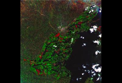
A natural color composite image from a Landsat 8 scene taken over Kenya's Rift Valley on May 1, 2014. Bright green areas show crops that started out well based on March rains, but may now face crop water deficits. Red areas indicate bare soil. Credit: UCSB
"This dataset seeks to blend the best qualities of rainfall station observations, satellite temperature data and rainfall's unique spatial characteristics to create the best available rainfall information for climate and agricultural monitoring," said Gregory J. Husak, an assistant researcher with the Climate Hazards Group in the UC Santa Barbara Department of Geography.
The new dataset allows experts who specialize in the early warning of drought and famine to monitor rainfall in near real-time, at a high resolution, over most of the globe. CHIRPS data can be incorporated into climate models, along with other meteorological and environmental data, to project future agricultural and vegetation conditions.
Specifically designed for drought monitoring, CHIRPS is already being used to identify possible hot spots of food insecurity. Much of East Africa is still recovering from a series of poor rainy seasons in 2008, 2009, 2011 and 2012. Food prices remain high, especially in South Sudan, where civil war has led to the displacement of more than a million refugees.
Kenya relies heavily on highly productive farms located in the Rift Valley by Lake Victoria. Usually, abundant spring rains support high crop yields that feed millions of people. This year, however, the CHIRPS dataset has identified a very poor start to the growing season. CHIRPS' long historical record indicates that April's rainfall total was the lowest in 34 years (about two inches for the entire month). This information has been passed along to the Famine Early Warning Systems Network of the U.S. Agency for International Development (USAID), prompting on-the-ground assessments of potential crop failure.
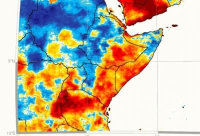
Spring-summer rainfall trends for East Africa and Yemen using a correlation between CHIRPS March-August rainfall and a linear trend. Credit: UC Santa Barbara
In addition to providing high-resolution, near real-time information to support early warning, UCSB and USGS scientists are also using the CHIRPS data to explore recent trends in rainfall. For instance, long-term rainfall has been declining across both the southwestern United States and easternmost part of East Africa.
The scientists are working with USAID to incorporate this information into development and adaptation strategies in Africa.
"Our most recent research suggests that these declines are likely linked to warming in the western Pacific and eastern Indian oceans," said Chris Funk, a research scientist with the USGS' EROS.


Comments