


A wildfire started by three vagrants with drugs in their possession spread quickly in the foothills northeast of Los Angeles on January 16th, 2014. The plume of ash and smoke blanketed much of the metropolitan area and prompted air quality warnings, along with concerns about long-term effects to the climate.
The Moderate Resolution Imaging Spectroradiometer (MODIS) on NASA's Terra and Aqua satellites captured these images of the Colby fire just before (top) and just after noon on January 16. The morning image is clearer because the scene was centered under the satellite, while the afternoon image is fuzzy because the satellite was observing from an angle.
According to InciWeb, the fire started around 6 a.m. Pacific Time on January 16 in Angeles National Forest near Glendora, California. As of 3 p.m. local time, nearly 500 firefighters were working the fire, which had destroyed 1,700 acres and at least two homes. Fire officials were concerned about gusty winds and extremely low humidity that could promote fire growth.
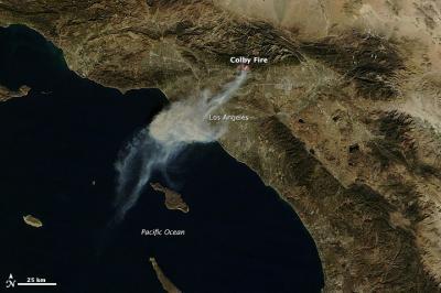
The Moderate Resolution Imaging Spectroradiometer (MODIS) on NASA's Terra and Aqua satellites captured this images of the Colby fire just before noon on Jan. 16. NASA image by Holli Riebeek and courtesy LANCE/EOSDIS MODIS Rapid Response Team at NASA GSFC. Caption by Michael Carlowicz.


Comments