


How are accurate are the world's most advanced weather forecasting models?
They perform okay, at least when it comes to predicting the very near future. Two University of Iowa researchers, David Lavers and Gabriele Villarini, evaluated rainfall forecasts from eight different global numerical weather prediction (NWP) models and their ability to predict the Sept. 9th-16th, 2013 extreme rainfall that caused severe flooding in Boulder, Colorado.
During September of 2013, Boulder County and surrounding areas experienced severe flooding and heavy rain resulting in fatalities, the loss of homes and businesses, and the declaration of a major disaster.
After the storms had subsided, Lavers and Villarini wanted to know how well some leading NWP models had done predicting it. Numerical weather prediction involves integrating current weather conditions through mathematical models of the atmosphere-ocean system to forecast future weather. For this study, the researchers selected the actual rainfall forecasts made by eight state-of-the-art global NWP models for the period of the Colorado floods.
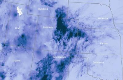
The dark blue areas over Colorado indicate regions that received more than 1,000 percent of their normal rainfall for Sept. 10-16, 2013. Courtesy of the U.S. National Weather Service Advanced Hydrologic Prediction Service.
"At an early lead time to the event, the rainfall forecasts failed to capture the persistent nature of the event's rainfall," says Lavers, corresponding author and IIHR – Hydroscience&Engineering postdoctoral researcher. "However, the rainfall forecasts from Sept. 9 (the first day of the event) did provide guidance indicating a significant period of rainfall in Colorado."
"Overall, these models tended to underestimate rainfall amounts and placed the rainfall in the wrong area, even though they provided an indication that a period of heavy rainfall was going to affect parts of Colorado," says Gabriele Villarini, study co-author and assistant research engineer at IIHR – Hydroscience & Engineering.
Lavers and Villarini used a reasonably coarse (having a relatively low number of pixels) global model output. The researchers emphasize that higher spatial resolution NWP models are likely to have captured the rainfall to a greater extent.
Says Lavers, "It is hoped that the continuing development of finer resolution NWP models that resolve the complex atmospheric motions in mountainous terrain, such as the Rocky Mountains, will make it possible to improve the forecasting capabilities of such extreme rainfall events."


Comments