


A new computer model has estimated ocean circulation during the last ice age, about 21,000 year ago, and believe that icebergs and meltwater from the North American ice sheet would have regularly reached South Carolina and even southern Florida.
Iceberg scour marks on the sea floor along the entire continental shelf lend weight to the model, says oceanographer Alan Condron from the University of Massachusetts Amherst. Such a view of past meltwater and iceberg movement implies that the mechanisms of abrupt climate change are more complex than previously thought. "Our study is the first to show that when the large ice sheet over North America known as the Laurentide ice sheet began to melt, icebergs calved into the sea around Hudson Bay and would have periodically drifted along the east coast of the United States as far south as Miami and the Bahamas in the Caribbean, a distance of more than 3,100 miles, about 5,000 kilometers."
Jenna Hill of Coastal Carolina University
analyzed high-resolution images of the sea floor from Cape Hatteras to Florida and identified about 400 scour marks on the seabed that were formed by enormous icebergs plowing through mud on the sea floor. These characteristic grooves and pits were formed as icebergs moved into shallower water and their keels bumped and scraped along the ocean floor.
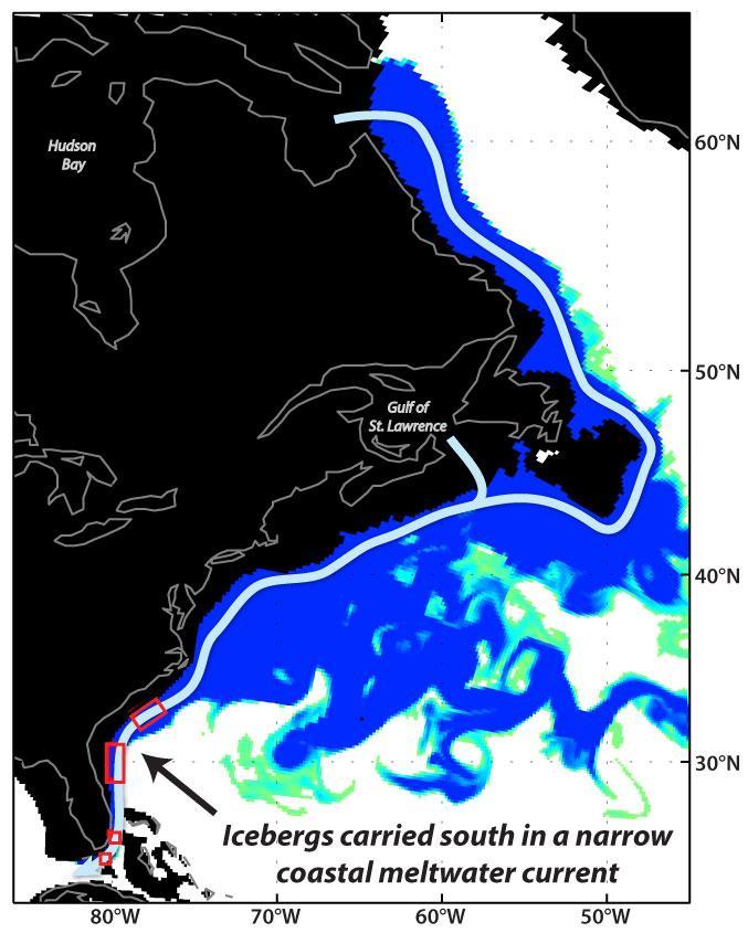
A possible pathway taken by icebergs from Hudson Bay, Canada, to Florida. The blue colors (behind the arrows) are an actual snapshot from the authors' high resolution model showing how much less salty the water is than normal. The more blue the color the less salty it is than normal. In this case, blue all the way along the coast shows that very fresh, cold waters are flowing along the entire east coast from Hudson Bay to Florida. Credit: UMass Amherst
"The depth of the scours tells us that icebergs drifting to southern Florida were at least 1,000 feet, or 300 meters thick," says Condron. "This is enormous. Such icebergs are only found off the coast of Greenland today."
To investigate how icebergs might have drifted as far south as Florida, Condron simulated the release of a series of glacial meltwater floods in his high-resolution ocean circulation model at four different levels for two locations, Hudson Bay and the Gulf of St. Lawrence.
Condron reports, "In order for icebergs to drift to Florida, our glacial ocean circulation model tells us that enormous volumes of meltwater, similar to a catastrophic glacial lake outburst flood, must have been discharging into the ocean from the Laurentide ice sheet, from either Hudson Bay or the Gulf of St. Lawrence."
Further, during these large meltwater flood events, the surface ocean current off the coast of Florida would have undergone a complete, 180-degree flip in direction, so that the warm, northward flowing Gulf Stream would have been replaced by a cold, southward flowing current, he adds.
As a result, waters off the coast of Florida would have been only a few degrees above freezing. Such events would have led to the sudden appearance of massive icebergs along the east coast of the United States all the way to Florida Keys, Condron points out. These events would have been abrupt and short-lived, probably less than a year, he notes.
"This new research shows that much of the meltwater from the Greenland ice sheet may be redistributed by narrow coastal currents and circulate through subtropical regions prior to reaching the subpolar ocean. It's a more complicated picture than we believed before," Condron says.
He and Hill say that future research on mechanisms of abrupt climate change should take into account coastal boundary currents in redistributing ice sheet runoff and subpolar fresh water.
Source: University of Massachusetts at Amherst


Comments