


On January 29 at 1430 UTC/9:30 a.m. EST, the Joint Typhoon Warning Center dropped System 91S from formation alert status, but the low pressure area still has a medium chance for development in the next 24 hours. System 91S was located near 18.2 south and 39.1 east, about 585 nautical miles northeast of Maputo, Mozambique. An image from India's Oceansat satellite indicated 20 to 25 knot (37.0 to 46.3 kph/23.0 to 28.7 mph winds over the eastern semi-circle of the storm. Meanwhile the NOAA-19 polar orbiting satellite data showed weak, shallow convective banding of thunderstorms wrapping into the low-level center on January 29.
System 91S is located in an environment with moderate vertical wind shear. The Joint Typhoon Warning Center noted that dynamic computer model guidance shows System 91S should weaken as it continues moving to the southwest.
Only one named tropical cyclone called Deliwe has passed through the Mozambique Channel so far this year but this analysis found that areas of the Mozambique Channel from southeastern Mozambique through western Madagascar have already had well above normal rainfall for the past 30 days.
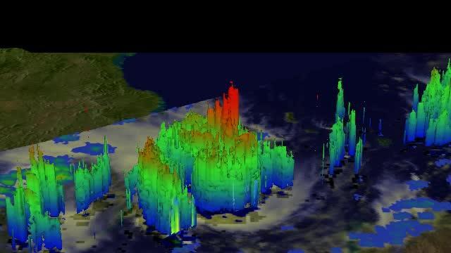
The TRMM satellite flew above a tropical low (91S) in the Mozambique Channel on Jan. 28, 2014, at 1011 UTC and saw some towering storms (red) near the center of the low were reaching heights of above 16 km/9.9 miles.
(Photo Credit: SSAI/NASA, Hal Pierce)
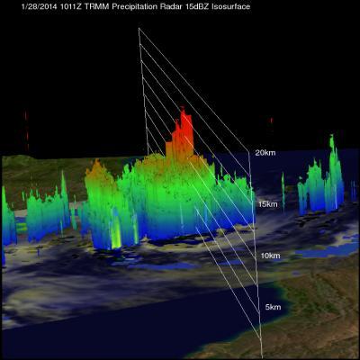
TRMM satellite flew above a tropical low (91S) in the Mozambique Channel on Jan. 28, 2014, at 1011 UTC and this 3-D view using TRMM PR data shows that some towering storms near the center of the low were reaching heights of above 16km (about 9.9 miles).
(Photo Credit: NASA/SSAI, Hal Pierce)


Comments