


8 of the top 10 U.S. cities that have seen an increase in nuisance flooding, which causes road closures, overwhelmed storm drains and compromised infrastructure, are on the East Coast, according to a new NOAA technical report.
If you want to get media attention, have something happen in New York City. A tropical storm can become a Super Storm and sea level rises will get attention once mid-town Manhattan Bruno Magli's start getting soaked. Once word leaks out that nuisance flooding has increased between 300 and 925 percent on the coasts since the 1960s, climate change will get real.
Not so much when Annapolis and Baltimore lead the list, though. Port Isabel, Texas also showed an increase of 547 percent, and nuisance flood days in San Francisco, California increased 364 percent.
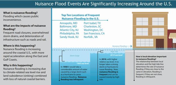
Nuisance flooding events have increased around the U.S., but especially off the East Coast. Click graphic for high resolution PDF. Credit: NOAA
"Achieving resilience requires understanding environmental threats and vulnerabilities to combat issues like sea level rise," says Holly Bamford, Ph.D., NOAA assistant administrator of the National Ocean Service. "The nuisance flood study provides the kind of actionable environmental intelligence that can guide coastal resilience efforts."
"As relative sea level increases, it no longer takes a strong storm or a hurricane to cause flooding," said William Sweet, Ph.D., oceanographer at NOAA's Center for Operational Oceanographic Products and Services (CO-OPS) and the report's lead author. "Flooding now occurs with high tides in many locations due to climate-related sea level rise, land subsidence and the loss of natural barriers. The effects of rising sea levels along most of the continental U.S. coastline are only going to become more noticeable and much more severe in the coming decades, probably more so than any other climate-change related factor."
The study was conducted by scientists at CO-OPS, who looked at data from 45 NOAA water level gauges with long data records around the country and compared that to reports of number of days of nuisance floods.
The extent of nuisance flooding depends on multiple factors, including topography and land cover. The study defines nuisance flooding as a daily rise in water level above the minor flooding threshold set locally by NOAA's National Weather Service, and focused on coastal areas at or below these levels that are especially susceptible to flooding.
The report concludes that any acceleration in sea level rise that is predicted to occur this century will further intensify nuisance flooding impacts over time, and will further reduce the time between flood events.
The report provides critical NOAA environmental data that can help coastal communities assess flooding risk, develop ways to mitigate and adapt to the effects of sea level rise, and improve coastal resiliency in the face of climate- and weather-induced changes.
Top ten U.S. areas with an increase nuisance flooding*
|
“Nuisance level”: Meters above mean higher high water mark |
Average nuisance flood days, 1957-1963 |
Average nuisance flood days, 2007-2013 |
Percent Increase |
|
|
Annapolis, Md. |
0.29 |
3.8 |
39.3 |
925 |
|
Baltimore, Md. |
0.41 |
1.3 |
13.1 |
922 |
|
Atlantic City, N.J. |
0.43 |
3.1 |
24.6 |
682 |
|
Philadelphia, Pa. |
0.49 |
1.6 |
12.0 |
650 |
|
Sandy Hook, N.J. |
0.45 |
3.3 |
23.9 |
626 |
|
Port Isabel, Texas |
0.34 |
2.1 |
13.9 |
547 |
|
Charleston, S.C. |
0.38 |
4.6 |
23.3 |
409 |
|
Washington, D.C. |
0.31 |
6.3 |
29.7 |
373 |
|
San Francisco, Calif. |
0.35 |
2.0 |
9.3 |
364 |
|
Norfolk, Va. |
0.53 |
1.7 |
7.3 |
325 |
* More than one flood on average between 1957-1963, and for nuisance levels above 0.25 meters.
Source: NOAA


Comments