


The study authors believe it could be used in monitoring carbon stocks for climate policy. Both above-ground biomass and carbon stocks are important details for UN-REDD, the United Nations initiative on Reducing Emissions from Deforestation and forest Degradation that is striving to keep the destruction of forests in check and thereby preserve the uptake of carbon by trees.
Lead author Dr. Kim Calders of Wageningen University said, “Terrestrial laser scanning, also called terrestrial LiDAR, allows us to measure biomass with far less uncertainty than before. The current methods yield results that may be off by as much as 37%. The LiDAR method, by comparison, delivers more than 90% accuracy and there is still room for improvement. We can now ‘weigh’ trees far more precisely and then determine their biomass. The current uncertainties about the presence of carbon in forests are, therefore, reduced.
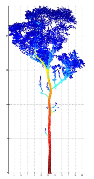
Lidar point cloud from a scanned Eucalyptus tree of about 25m in height. The colors represent the size of 'patches' used to cover the points in calculating tree volume, blue being small, red being large. Credit: UCL
“We have proved in Australia that the method works. Terrestrial laser scanning is an active remote sensing technique that can measure precise distances by sending out laser energy and then analyzing the reflected energy. The instrument used in this work is a laser scanner that is positioned below canopy. Whereas the error increases for trees with larger diameters using the current methods, this is not the case with this new method. Furthermore, it is now also possible to determine the biomass of specific branches, something that could not be done before. As a result, how much biomass has been lost after a big storm can be precisely determined. In contrast, current methods of indirect measurements are based on the height and diameter of the tree, so no change is detected if the loss of a branch does not change these parameters.”The method will now be tested in forests that are potentially more important for worldwide carbon stocks than Australian forests, e.g. tropical forests in Gabon, Peru, Indonesia and Guyana.
Co-author Dr. Mat Disney, a geographer at University College London, said, “This new paper shows how effectively we can now turn highly-accurate laser measurements, comprising millions of 3D laser points, into estimates of tree mass. Weighing trees is really hard - time consuming, expensive and destructive - and so it's done very rarely, particularly in tropical forests where trees can be 50m or more and weigh over 100 tonnes. As a result, all current estimates of tropical forest carbon stocks are based on a very, very small number of weighed trees.
“We're working with Kim and colleagues elsewhere to extend these measurements to forests across the tropics. Our group at UCL has recently returned from an expedition to Brazil where we've collected laser scan measurements of over 1000 trees in just 10 days as part of an experiment to understand the impact of drought on the Amazon rainforest.”
Source: University College London


Comments