


If you're not convinced that Planet Nibiru is not hiding in an multiverse pocket of dark matter or you just want to know the best way to get to constellation Boötes so you can ask the residents of Gliese 526 if they got that email you sent from Lone Signal, a new 'GPS' tool can help.
But baby steps first.
While global positioning often works great, that 'global part' is a limiting factor. Our existing system of GPS can be off by 10 m and 0.01 mms−1 over time and is limited to using Earth for reference. If you think a car GPS can be a little crazy driving around Florida, image being 15 light years away. Pictures, and then calculating the changes in the location of stars, can work, but what if you want to be really accurate? To get to where you want go go outside the solar system, you really need an on-board navigation system.
Researchers from China and Australia have found a way to calibrate pulsars so they do the job. They call their software TEMPO2. These tiny stars regularly emit radio waves and X-rays and that tells scientists a lot about how things move. In the case of binary pulsars PSR J0737-3039A and B, measuring those waves over time, astronomers were even able to detect their spin axis precession in an area less than the size of our sun, because the highly magnetized region surrounding one blocks the radio waves being emitted by the other.
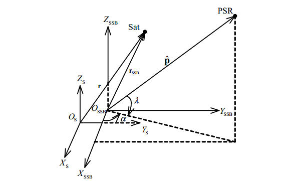
Geometric relationship between the spacecraft, pulsar, Sun and the solar system barycentre (SSB) establish “barycentric arrival times”. Credit: arXiv:1307.5375
Those slight deviations in arrival time may do the trick.
The idea is not new. Scientists had worked out a hypothetical method in 1974 and science-fiction had written about autonomous navigation before that. But those were all super versions of gyroscopes and accelerometers, great for Steampunk stories but not as much fun when your life is at stake. Precisely measuring when pulsars arrive, from four locations (triangulation plus one), would go beyond telling us where they are, it can also work backwards and tell you where you are.
Researchers have created a software tool that can use pulsars to precisely determine where their telescopes are and that means "If the telescopes were on board a spacecraft, then we could get the position of the spacecraft."
Recalibrating takes observing at least four pulsars once per week. Each observation takes about an hour and small, lightweight X-ray detectors make it feasible. Using TEMP02 their simulation successfully navigated a spacecraft to Mars without any help from Earth.
"The spacecraft can determine its position to within about 20 km, and its velocity to within 10 cm per second," said co-author Dr. George Hobbs of CSIRO in their statement. "To our knowledge, this is the best accuracy anyone has ever been able to demonstrate. Unlike previous work, we've taken into account that real pulsars are not quite perfect, they have timing glitches and so on. We've allowed for that."
They have used TEMP02 code to do other fun things, like confirm the mass of Saturn to 6 decimal places using pulsar waves. And they are making that call that Planet Nibiru and other hidden masses do not exist. The pulsar signal arrival would be changed. "Even if a planet is hard to see, there's no way to disguise its gravitational pull," Hobbs said. "If we don't detect the gravitational pull, then there's no planet there. Full stop."
Accepted for publication by Advances in Space Research.
Preprint: X. P. Deng, G. Hobbs, X. P. You, M. T. Li, M. J. Keith, R. M. Shannon, W. Coles, R. N. Manchester, J. H. Zheng, X. Z. Yu, D. Gao, X. Wu, D. Chen, 'Interplanetary spacecraft navigation using pulsars', arXiv:1307.5375


Comments