

In 2005, as Greenland's glacier cover receded due to global warming, what had formerly been known as a cape was shown to be an island. It made headlines. On the west coast of Northbrook island in Franz Joseph Land lies Cape Flora. It was there that Fridtjof Nansen was greeted by Frederick George Jackson after Nansen's 'Furthest North' trek. It was there also that Benjamin Leigh Smith was shipwrecked in 1881. In 1980 it was discovered by Russian explorers following major ice retreat since the 19th century that Cape Flora is in fact an island. By 2011 Jackson's camp site had been lost to coastal erosion.

Jackson's camp at Cape Flora June 1896
It is safe to predict that, as ice cover continues its retreat, many more 'warming islands' will be revealed. If anyone wants to cling desperately to the 'natural cycles' theory, even while the Arctic Sea ice is 'circling the drain'*, I suggest they get busy right now looking for old maps which have been drawn by graphic artists without reference to actual data. That is the only way they are going to "prove" that all of the new 'warming islands' which are going to be revealed are "already known".
* From a comment by GreenOctopus at Neven's Arctic Sea Ice Blog.
An aside
A brief history of Arctic science. At first we got our Arctic knowledge from philosophers. Then we got our Arctic knowledge from the Inuit. Then we got our Arctic knowledge from scientists. Then the scientists decided that maybe the Inuit knew a thing or two about the Arctic. Then we divided the Arctic into east and west and kept our knowledge secret from each other. The Arctic was for a long time explored more extensively by Russia, and in more detail, than by any other country, so we have a wealth of data about Arctic warming going back to before the 19th century. It just needs to be translated into English so that more scientists can make use of it.

Heart shaped lake on Spitzbergen
"Dr Bryn Hubbard, of Aberystwyth University, said: ‘The glaciers all through this island chain have receded, but the heart shape is an anomaly. You would do well to find another."
from a Daily Mail article.
Dennis Schmitt
In September 2005 the melting of land ice in Northeast Greenland revealed an island which - since 1822 - was thought to be a cape. Dennis Schmitt, its discoverer, named it "Uunartoq Qeqertoq", Inuit for "Warming Island". It had been uncovered due to local warming since his explorations there ten years previously.
When Warming Island was news, Patrick Michaels' claimed that it was "known to be an island back in the early 1950s". Unfortunately for Patrick Michaels' reputation as a science writer he quite forgot to do any real science. I wrote an article in rebuttal to Michaels in which I showed that his claim was based on an illustration which was most probably a publisher's graphic artist's sketch. It was used as graphic art for Ernst Hofer's 1957 book of Arctic photographs. The map is not marked with a scale. It carries no cartographer's name, no initials, no brand, no mark of cartographic authenticity.
The discovery of a new island would entitle Hofer to 'stake his claim', but in his book he specifically stated:
"I do not claim, in the following pages, either to communicate specialised scientific knowledge or to give an account of sensational adventures and discoveries. I have merely tried to convey, simply and objectively, the impressions that the Arctic made upon a newcomer"
I don't claim to know why there are science contrarians or why they love to pick cherries from the tree of knowledge. I only know that before I write anything which they would consider to be controversial, I try to discover what they have already said on the topic. Intending to write this article about how receding glacial ice will reveal - and is revealing - new islands, I checked my historical sources to see how the glaciers behaved in the past, and then went over to WUWT.
My major source for this article is Nikolai Nikolaevich Zubov. He was the foremost of Russia's many Arctic experts and wrote the 'Arctic watcher's bible'. It is called, naturally enough "Arctic Ice". It contains knowledge about land, sea, ice and air much of which has stood the test of time. The book contains a wealth of historic data about the Northern Route and the half of the Arctic of most interest to people wanting to navigate the Northern Sea Route aka the North East Passage. It is freely available for download as pdf or plain text, or for viewing on-line at openlibrary.org. N.N. Zubov, Arctic ice, Moscow 1943, Translation by U.S. Navy Oceanographic Office and American Meteorological Society. Published 1963 by U.S. Navy Electronics Laboratory in San Diego, Calif.
Anthony Watts pasted snippets from Zubov's book as if they constitute some sort of "proof" of natural variability. If only he had posted some of the most pertinent images together with the relevant text then he might have educated his readers.
Watts said: "I urge readers to have a look at some of the excerpts I’ve posted." I would prefer our readers to read the whole book, or at least to read Chapter 13 on seasonal and long term fluctuations of ice abundance in its entirety.
Watts has highlighted this part of page 472 but has not given any explanation or context:
" ... the ice area in the Greenland Sea in April to August for the period 1921 to 1938 is 15 to 20 per cent less than for the period 1898 to 1920. From my calculations, the ice abundance in the Barents Sea for the same months from 1920 to 1933 was 12 per cent less than for the period 1900 to 1919. "Zubov, having discussed Arctic warming at various places throughout his book, shows that the Arctic sea ice margin has been retreating almost continually since the 19th century. Note the sequence of reduction from 1898 to 1938. The previous section, 161, gives extensive information about the Russian sector warming of 1943, when the snow melted some two weeks earlier than the then norm. That makes a warming period from 1898 through 1943. Despite some brief cold snaps here and there in the Arctic since 1943 the sea ice margin has continued its retreat.
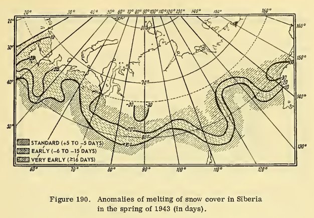
Figure 190 - Anomalies of melting snow cover in Siberia in the spring of 1943 (in days.)
From chapter 13.
We can see at a glance just how much less ice there is now than in 1943. Writing about ice extent in Baffin Bay, Zubov says, in chapter 13:
Sailing into the northern part of this bay in the summer, very often after several days or even weeks of struggling with the ice, a large expanse of clear water opens up, extending almost to Smith Sound.Today's ships do not struggle with the sea-ice in summer. There is virtually none to struggle with.

Baffin Bay July 2012
Watts jumps from page 474 to page 476. On page 475 is paragraph 8 on ship navigation. Watts has written much on this topic, usually suggesting that there was plenty of open water in the past, thus belittling the brave men who first explored the North West Passage.
Paragraph 8 has this to say about ship navigation in the Arctic:
8. Ship navigation. A ship passing through an ice region is not always an indication of greater or lesser ice abundance of that region. The proper choice of course and time of passage may assure the success of the operation while an incorrect choice of these conditions by a ship of the same type may create the impression of great quantities of ice.Watts' snippet from page 476 starts with the rather odd "ular region." The complete sentence reads:
...
... accumulated knowledge and experience make present-day [1943] navigation considerably easier. We may nevertheless point out a number of ship voyages which could hardly have been accomplished in the preceding cold period. Among these are: our voyage on the sail- motorboat Knipovitch around Franz Joseph Land in 1932, the rounding of Severnaya Zemlya by the icebreaker Sibiryakov in the same year, through passages by ordinary steamships of the whole Northern Sea Route in 1935 (no ice being found on the route), etc. Further we know that starting with 1930 there was not a single year when it would have been Impossible to round Novaya Zemlya from the north even in a ship which was entirely unsuited for navigation in ice. At the same time we know that the icebreaker Yermak in 1901 attempted to round Cape Zhelania from the west and was unsuccessful, although the Yermak spent almost a month in a struggle with the ice while waiting at the northwest shores of Novaya Zemlya.
"Still more remarkable is the fact that the warming of the arctic is not confined to any particular region."Indeed: the whole Arctic has been warming almost unabated since the late 19th century.
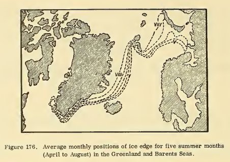
Figure 176 - Average monthly positions of ice edge for five summer months (April to August) in the Greenland and Barents Seas. Those monthly ice edges are now shifted so far north as to leave Svalbard and Spitzbergen in open water for much of the Arctic summer.

Figure 177 - Ice conditions in the Greenland and Barents Seas. May 1935.
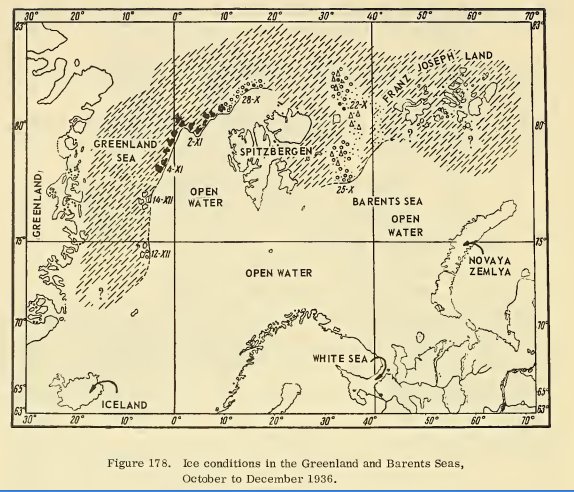
Figure 178 - ice conditions in the Greenland and Barents Seas, October to December 1936.
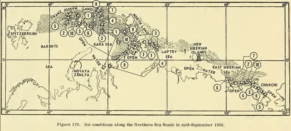
Figure 179 - Ice conditions along the Northern Sea Route in mid-September 1936.
The images immediately above are all from Zubov's chapter 13. Currently the summer ice edge is further north than in 1943 and ice volume is very much less.
Given the simple fact of a continua decline in Arctic ice both on land and sea it is only to be expected that our maps of the Arctic will need to be updated frequently as new islands appear and as coasts erode away.
I will end my extracts from Zubov's Arctic Ice where Watts begins, with my emphasis:
Section 162. Warming of the Arctic
Along with the fluctuations in ice abundance in each individual sea from year to year, in late years a most interesting phenomenon has been observed -- a warming of the arctic, as evidenced by a gradual and universal decrease in ice abundance. The main evidences of this general warming of the arctic are:
1. Receding of glaciers and "melting away" of islands. According to the testimony of Wegener, all the Greenland glaciers which descend into Northeast Bay and Disko Bay, have been receding since approximately the beginning of the present century. In particular the Jakobshavn glacier receded about 20 m during the period 1880 to 1902. As has already been mentioned, the glaciers of these two bays produce the main mass of the Greenland icebergs. Receding of glaciers during recent years has likewise been observed on Spitzbergen, Franz Joseph Land, and Novaya Zemlya.
On Franz Joseph Land during recent years several islands have appeared as if broken in two. It turned out that they had been connected up to that time by ice bridges.
Conclusion
Given a wealth of historic information about Arctic ice retreat since the late 19th century and perhaps earlier, current Arctic ice retreat cannot be explained as merely a matter of natural variability. Natural variability is superimposed as cyclic variations in the amount of Arctic land and sea ice which is in an obvious and scientifically undeniable downward trend. Loss of ice cover has an effect on regions beyond the Arctic. Global warming, as the name suggests, is not confined to the Arctic: rather, warming is currently at its greatest in the Arctic.
I will end with an extract from Watts' own blog:
"Many GISS stations north of 60 latitude show temperatures 70 years ago being nearly as warm as today. This pattern is seen from Coppermine, Canada (115W) all the way east to Dzardzan, Siberia (124E.) The 30 year satellite record seems to correspond to a period of warming, quite similar to a GISS reported period in the 1920s and 1930s. Is it possible that Arctic temperatures are cyclical rather than on a linear upwards trend?"
Steven Goddard, WUWT
“Analysis of the temperatures does not support a cyclic explanation for the recent warming. The warming during the 1920s and 1930s was more regional in nature and focused on the Atlantic side of the Arctic (though there was warming in some other regions as well) and was most pronounced during winter. In contrast, the current warming as observed is amplified over almost the entire Arctic and is seen in all seasons. Another thing that is clear is that, the warming during the 1920s and 1930s was limited to the Arctic and lower latitude temperatures were not unusually warm.”
Walt Meier, NSIDC
From an interview reported at WUWT.
Further reading
For an excellent and very extensive history of warming in Northbrook and Cape Flora, please see:
http://www.franz-josef-land.info/index.php?id=649&L=5
Continued in New Arctic - New Discoveries
Related reading from my blog:
Arctic 2013
Pollution And Parliament
The World Is Getting Cooler*
.


Comments