

Petermann Ice Island (2010) Calved on August 05 2010. The calving had been anticipated for some time and had been predicted to occur in summer 2010 by a number of people, including myself. The actual calving event was observed in near real-time images by a number of people - credits at the foot of this article.
I give here some more background to my observations and my predictions of the Petermann calving event in a wider context of mechanical forces which may act on glaciers.
Greenland under observation
In a warming world, the greatest warming was expected to occur at the poles. The Arctic, as can be determined from a study of historic records, has been warming since about 1900 at an ever increasing rate. This warming has caused a shrinkage of the edge of the 'permanent ice' which once made Greenland's east coast inaccessible except by kayak and sledge. The summer minimum has now shrunk to an entirely trivial amount. The Odden ice tongue has not been observed for some years. Warm waters which were once kept offshore by the ice barrier are now lapping at many marine outlet glaciers. Along Greenland's east coast, only Zachariea and 79N are bounded by sea ice as I write these words, but that sea ice is breaking up rapidly. The sea ice boundary has also retreated since about 1900 along Greenland's west coast and in Baffin Bay.
This section of a map published in 1939 shows the summer minimum ice extent for that era. Note particularly the extent of what was still known then as the Great Ice barrier on Greenland's east coast.
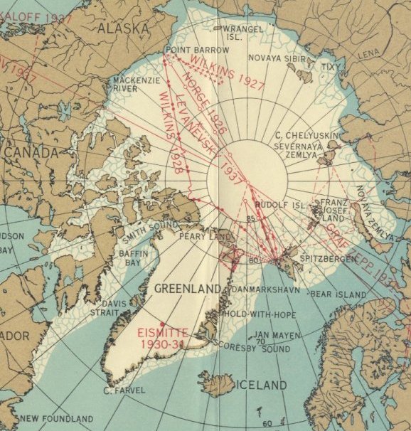
Arctic ice minimum extent 1939
The Arctic has warmed progressively since about 1900. Today, Arctic sea ice mass is lower than has ever been recorded in any area by any observer before the age of satellites. Much, if not most of the mass loss is due to ocean warming. Ocean warming accelerates land ice loss when it accelerates the flow of marine outlet glaciers.
September 2008
Glacier acceleration through subsurface ocean warming
The sudden acceleration in 1997 of Jakobshavn Isbræ, one of Greenland's largest outlet glaciers, was caused by subsurface ocean warming, according to research published online in Nature Geoscience. The study suggests that ocean temperatures may be more important for glacier flow than previously thought. The prediction of future rapid dynamic responses of other outlet glaciers to climate change may therefore require detailed knowledge of regional ocean dynamics.
David Holland and colleagues present hydrographic data that show a sudden increase in subsurface ocean temperature in 1997 along the entire west coast of Greenland. The arrival of relatively warm water that originated from the Irminger Sea near Iceland could therefore have triggered the increase in the glacier speed. The authors trace these oceanic changes back to changes in the atmospheric circulation in the North Atlantic region.
Acceleration of Jakobshavn Isbræ triggered by warm subsurface ocean waters
David M. Holland, Robert H. Thomas, Brad De Young, Mads H. Ribergaard&Bjarne Lyberth
Published online: 28 September 2008 | doi 10.1038/ngeo316
On February 16, 2010 Alan Buis reported:
Glaciers in west Greenland are melting 100 times faster at their end points beneath the ocean than they are at their surfaces, according to a new NASA/university study published online Feb. 14 in Nature Geoscience. The results suggest this undersea melting caused by warmer ocean waters is playing an important, if not dominant, role in the current evolution of Greenland's glaciers, a factor that had previously been overlooked.
Researchers Eric Rignot and Isabella Velicogna, both of NASA's Jet Propulsion Laboratory, Pasadena, Calif., and the University of California, Irvine; along with colleague Michele Koppes of the University of British Columbia, Vancouver, Canada, measured the undersea melting rates of four glaciers in central west Greenland in the summer of 2008. They deployed oceanographic equipment in the glacier fjords, sampling the water at various depths to measure ocean currents, temperature and salinity, along with the depth of the fjords. The researchers found the melt rates of the glaciers studied was 100 times larger under the ocean at their terminus points than that observed at the glacial surfaces.
"All major Greenland glaciers end up in the ocean, and tidewater glaciers control 90 percent of the ice discharged by Greenland into the sea," Rignot said. "Submarine melting may therefore have a large indirect impact on the ice mass budget of the entire Greenland Ice Sheet. If we are to determine the future of the Greenland Ice Sheet more reliably in a changing climate, more complete and detailed studies of the interactions between ice and ocean at the ice sheet's margins are essential."
http://www.jpl.nasa.gov/news/news.cfm?release=2010-050
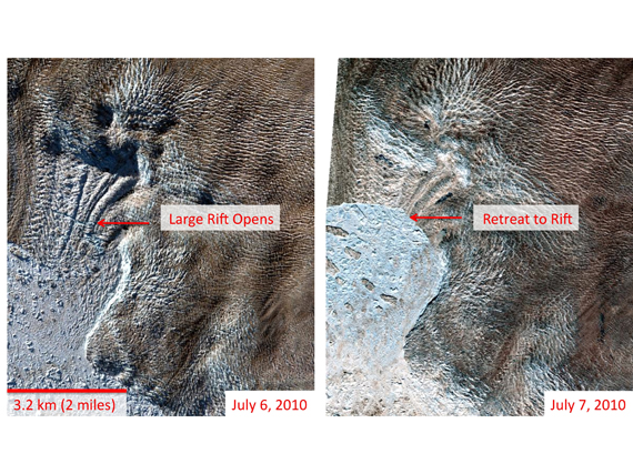
When Jakobshavn Glacier calved, July 06 2010, the way it was reported suggested that the detection and reporting of such a large calving event was somewhat unusual.
Research teams led by Ian Howat of the Byrd Polar Research Center at Ohio State University and Paul Morin, director of the Antarctic Geospatial Information Center at the University of Minnesota have been monitoring satellite images for changes in the Greenland ice sheet and its outlet glaciers. While this week's breakup itself is not unusual, Howat noted, detecting it within hours and at such fine detail is a new phenomenon for scientists.
http://www.nasa.gov/topics/earth/features/jakobshavn2010.html#
I have been observing the Arctic closely, especially this year, via MODIS near real-time images, and have written fairly regular Arctic ice reports since Arctic spring. Sea ice and land ice can interact via mechanical forces where they are in contact, especially in bays and fjords. Solidly frozen and immobile melange can exert backforce on a glacier sufficient to substantially impede calving. Jakobshavn Glacier , I suggest, provides an excellent example of this mechanism.
My focus this year has been on the Nares Strait area, the Flade Isblink area and the main Arctic sea ice cover, as well as Greenland's glaciers. I work alone from home with no funding and no assistance other than the excellent inputs from my readers. No person working alone can hope to examine every detail of every MODIS image. My first knowledge of the July 06 calving of Jakobshavn came when I read Jakobshavn Iisbræ on Neven's excellent Arctic Sea Ice blog.
Just before Jakobshavn calved, a pulse of meltwater appears to have flowed across the middle of the Jakobshavn melange. A pulse of water can flow at great speed underwater in a river, canal or fjord, exerting great force on any obstacle. It seems to me that the pulse could easily have triggered an impending calving event.
Satellite images seem to me to show a higher than normal water level immediately after the calving. A tsunami-like surge of water is entirely consistent with a large calving. The reported calving showed what appeared to be such a water surge in MODIS images.
I expected that the tsunami-like surge would bring forward a calving in the adjacent Jakobshavn South branch of the glacier. I observed that calving and published an article -
Jakobshavn Glacier Second Calving ?
The image below is an adaptation of a NASA image. The red lines and arrows show the meltwater pulse referred to. The green arrows show where a part of the energy would have gone, in my opinion.
Annotated image of Jakobshavn glacier retreat.
image source: http://svs.gsfc.nasa.gov/
This animation from my article Jakobshavn Glacier Second Calving ? uses two images from July 02 and July 05 shows the meltwater pulse. The images are widely separated in time because cloud cover made other images less useful.
Jakobshavn July 2 and July 5 2010
Note that the bottom right quarter of the image shows a motion artifact due to image distortion. The ice and calving fronts appear to be moving, but so does the land in that area.
It appears to me that a surge of meltwater has pushed melange around. Some melange is pushed back up-channel towards the calving fronts.
Due to extensive cloud cover, images of the second calving were not clear enough to show the extent of the calving. I made an animation from images which clearly show the calving front as it was early this year and as it was shortly after the two calving events. The animation was first posted in an article about ice arches and ice bridges - Bridges That Build Themselves.
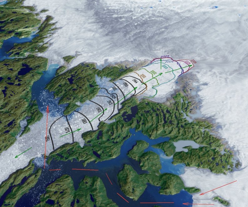
Jakobshavn calving front retreat to July 19 2010
MODIS Rapidfire images from March 08 and July 19 2010
The Jakobshavn South calving appears to me to be greater than the Jakobshavn North calving, but that needs to be confirmed independently.
The retreat of the calving front of Jakobshavn Glacier has now produced two separate calving fronts. The two streams formerly flowed together into a fairly wide and straight fjord. The streams appear to me to have exerted some influence on each other in the form of mutual back-pressure. The retreat to two fronts may be expected to accelerate ice loss significantly, but not greatly. The first Jakobshavn calving event attracted quite a lot of media attention. The second calving, none.
Petermann Ice Island (2010) revisited
In engineering it is widely known that stresses can build up in a material or structure for quite some time before reaching the point of sudden catastrophic failure. In most cases there are tell-tale signs of impending failure. Necking is a classic example: a material in simple tension will be reduced in cross-section area non-uniformly and will yield at a highly localized point. Another widely-known failure mechanism is the spreading of cracks. Materials fail catastrophically when the rapid spread of cracks causes shattering. This can cause earthquakes. It can cause failures in man-made structures. Ice is exceedingly prone to fracture.
Backpressure is a very important factor in many branches of engineering. It is not widely known that the exhaust pipes of both internal combustion engines and steam engines are designed to exert a back-pressure on the exhaust gases so as to promote efficiency. Some single-cylinder two-stroke engines simply will not run in the absence of that back-pressure.
I suggest that back-pressure from geological features and from the sharing of a glacier outlet by two or more streams is an important factor in considering the growth and retreat of glaciers.
In most cases, as tributaries join main glacier outflows they add to lateral pressures. This can help maintain integrity in the glacier stream taken as a whole. I suggest that each stream creates a backforce on every other stream such as to slow down the glacier and its tributaries overall. As a glacier retreats past a tributary it may be expected to accelerate in some proportion to the amount of ice contributed by the tributary.
It appears to me that in the case of Petermann Glacier, the tributary streams have not acted so as to add to transverse pressure: the tributaries have not acted to strengthen the outlet and maintain its integrity. Quite the reverse.
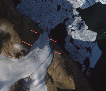
The following images show what I term 'chatter zones' in tributary streams. Chatter is a term from engineering which refers to a cutting tool vibrating and so making a very rough and 'chunky' cut. If a tributary joining a main glacier outflow consists of separate chunks rather than a continuous stream it will cause shocks in the main stream as the forces in the stream attempt to rotate the components of the incoming tributary stream. As the tributary is forced against the fjord wall by the main stream, instead of being extruded it will remain as broken and ragged lumps. Instead of ice streams sliding smoothly past each other there will be a great deal of 'grip and slip'.
This image - available in very high resolution from the NASA site - shows the ice island as it was on August 16 2010. The annotations are mine.
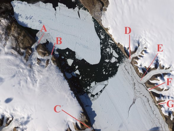
Petermann Ice Island (2010) August 16 2010 - with annotations
image source: http://earthobservatory.nasa.gov/IOTD/view.php?id=45306
All of the following images are sections of the above linked image.
.
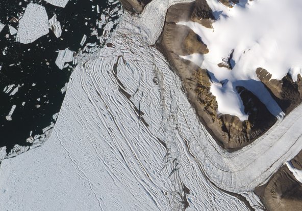
Petermann Glacier fissure.
This fissure extends across about 60% of the floating ice tongue. I expect that when this large ice island detaches it will do so by rotating anti-clockwise, this being due to forward thrust opposed by drag in the region downstream of tributary C.
.

Tributary at A
This appears to be an icefall. The recent ice island calving will make little or no difference to this tributary's calving rate.
.
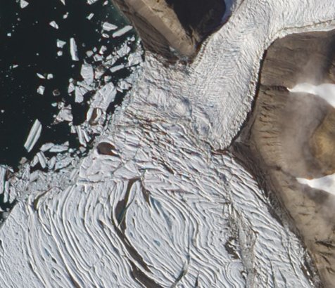
Tributary at B
There appears to be a trough-like feature between two ridges. I would expect calving in this region, but no immediate acceleration.
.
Tributary at C
Retreat of the glacier tongue is unlikely to cause acceleration of this icefall.
.
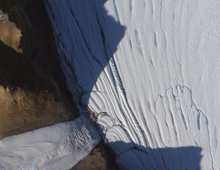
Tributary at D
This tributary in its flow has been subjected to chatter along its edges and has become heavily crevassed. On being forced through nearly a right angle turn by the main stream it had become very weak and fragmented. From my observations it appeared that it was the sea-ice component of the melange that was doing most of the work of providing lateral support to the ice tongue. It seemed to me that once that sea ice melted, leaving relatively loose tabular bergs, a large mass of ice would detach, which indeed it did.
.
Tributary at E
Here again a stream with chatter zones merges with the main stream and is forced to turn through about 90 degrees. However, the pressure of the main stream is enough to rapidly compress the tributary flow against the land. I suggest that in the absence of tributary D, the flow would merge and smooth out. However, the two streams being in such close proximity seems to increase the amount of disruption to ice flow.
.
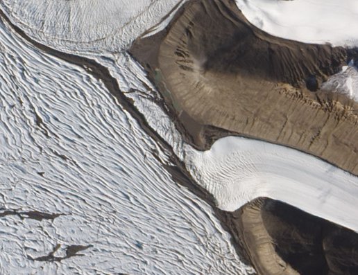
Tributary at F
This tributary seemingly contributes so little lateral pressure that it is squeezed almost to vanishing point between the main stream and the downstream tributary.
.
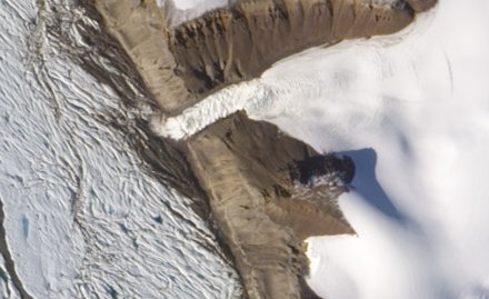
Tributary at G
This tributary seemingly makes no significant contribution to the stream dynamics.
.
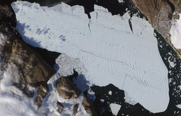
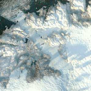
Petermann Ice Island (2010)
Note the meltpools and streams on the surface. There are many cracks and stress points, so this ice island is most unlikely to stay in one piece for long. However many pieces it breaks into, those pieces will be impacted by hundreds of icebergs from the rapidly calving Humboldt Glacier in passing through Kane Basin. A series of ever-smaller ice islands will - I suggest - move in a stop-start fashion as they follow currents and continually run aground.
With so many inlets, shoals and shallows to ground in it is highly unlikely in my opinion that any unusually large part will survive to reach Atlantic shipping lanes.
.
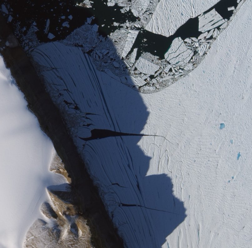
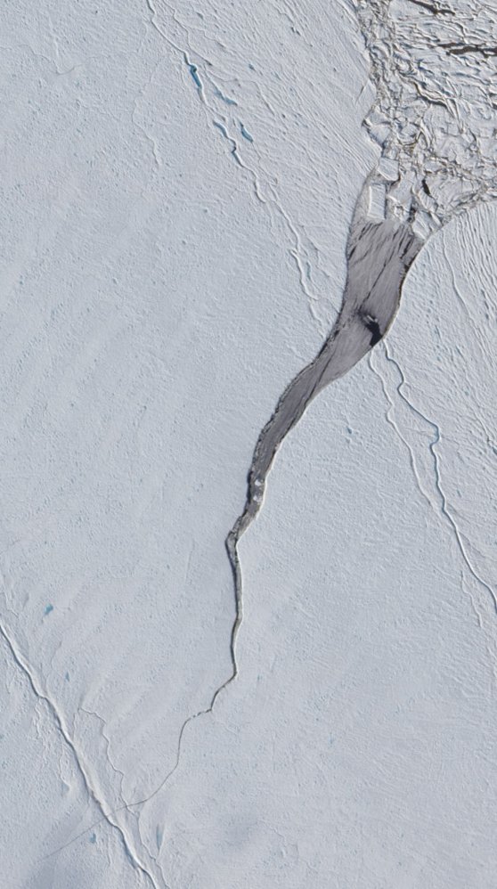
New calving front detail
I suggest that further ice breakup in the zone which is in shadow will relieve enough lateral pressure to permit a new ice island to form by rotating anti-clockwise into this zone.
Tributaries and ice retreat
As a glacier retreats past its tributaries I would expect to see accelerations in proportion to the relative proportions that each component stream contributed to the main stream. To a first approximation I suggest that the width of sub-streams will be in some proportion to their contributions to the main stream.
Suppose for example that a tributary is compressed to 50% of its former width so as to occupy 25% of the downstream glacier. On retreat past the tributary the main flow, being relieved of the backpressure due to the tributary will increase its rate of flow by 33%. The tributary outflow will increase by 50% in the example given.
In the case of Jakobshavn Glacier the two new calving fronts taken together are little wider than the former single front. Until retreat further subdivides the streams I would not expect much acceleration from the relief of the backpressure caused where streams combine.
In the case of Petermann Glacier I would expect a very rapid retreat as the chatter zones are eroded by warm sea water, leaving the tongue virtually unattached to land at its sides. Further general Arctic warming and local warming will, I suggest, cause retreat of the tributaries and mass loss in local ice caps.
With every loss of sea and land ice there is a loss of thermal capacity. Heat which would formerly have raised a vast mass of ice from extremely low temperatures to temperatures still below zero C can raise the temperature of smaller masses to the melting point.
Together with loss of albedo the loss of the thermal capacity of ice will act as a positive feedback to further ice loss. The heat which would have been absorbed by ice is now absorbed by land, water and air. Before sea ice can form or thicken the excess heat must be radiated to space or advected. Sea ice can reduce or halt the calving of marine outlet glaciers. As the Arctic moves to a phase in which most sea ice is first year ice, Greenland will move to a phase in which, I suggest, the calving season will lengthen until most or all of Greenland's glaciers calve freely all year round, unrestrained by thin and sparse sea ice.
Prediction and observation credits
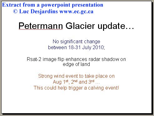
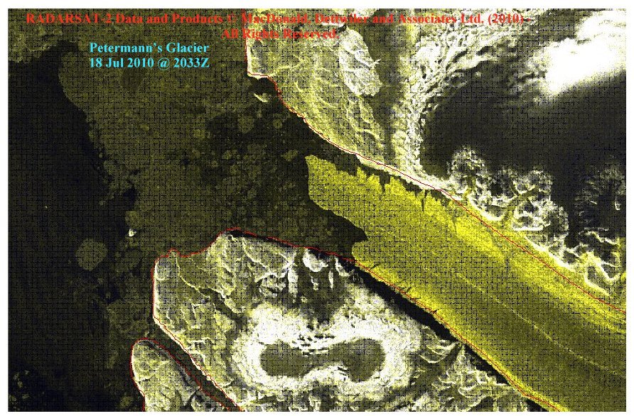
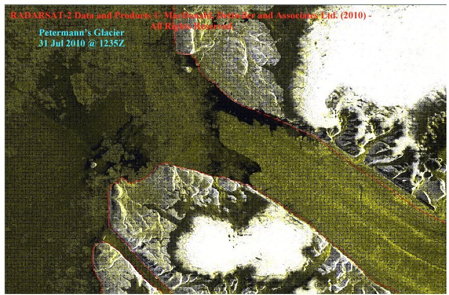
Luc Desjardins Senior ice and iceberg forecaster, Environment Canada - http://www.ec.gc.ca - predicted the calving in an internal departmental PowerPoint presentation on July 31 2010. For the benefit of my readers who may not have PowerPoint installed I have, by kind permission of Luc Desjardins, extracted the data for presentation here.
Edit: I am happy to correct this information, quoting a comment made below by
Andreas Muenchow
The manuscript attributed to Dr. Melling, DFO, Canada was submitted for publication in J. Geophys. Res. by its first author Dr. Helen Johnson, Oxford University, England on July-11, 2010. It relates to the regional oceanography of Petermann Fjord and is posted at the University of Delaware as
http://muenchow.cms.udel.edu/papers/Johnson2010JGR.pdf
Mauri Pelto has been watching this glacier for some two years in anticipation of a large calving event. On July 03 2010 he wrote this comment in Neven's blog:
I agree Neven that the glacier ice front did not change in 2009 and yes what is disappearing is just the sea ice in front of the glacier tongue. The reason this tongue is vulnerable is that it is only on the order of 70 meters thick at the end with less than 10 m of free board. This is typical for a small ice shelf not a big Greenland outlet glacier. I do expect a notable calving retreat this summer. The reduced snowcover indicates a more advanced stage of melting in the region this year, which was the case in 2008 as well.Mauri Pelto is the author or co-author of many scientific papers on glaciers. Two of his articles on the topic of Petermann Glacier may be seen here:
http://glacierchange.wordpress.com/2010/03/27/petermann-glacier/
http://www.realclimate.org/index.php/archives/2008/10/what-links-the-ret...
My own contribution
As noted in previous articles I forecast this calving twice:
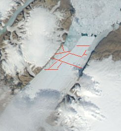
Judging by previous behavior and by the forces which will act on a more mobile ice tongue, I predict some dramatic calving this year. The image below shows red lines where I expect the tongue to calve.
July 17th 2010 07:26 PM
Arctic Ice July 2010 - Update #3
The Petermann ice tongue looks primed to lose a few fairly large floes any day now. There are a lot of cracks showing at 250m resolution. That means the cracks must be at least 250m wide.
...
It looks like a few small bergs- about 2 or 3 km across - are going to break off before the main tongue breaks up. The bigger fracture back at the tributary glaciers needs a lot of back-pressure relieved before it can expand much.
...
The Petermann ice tongue tip has held almost the same shape since winter 2008. It has had nearly two years in which to thin and crack. I would be very surprised if it does not retreat substantially this year.
July 22nd 2010 03:32 PM
Arctic Ice July - Update #4
Science20.com was the first science news outlet to publish the news when the giant ice island calved and I published, shortly afterwards, on August 05 2010, my article
Arctic Newsflash! Petermann Ice Tongue Loses Huge Chunk
My previous Petermann glacier articles:
Arctic Newsflash! Petermann Ice Tongue Loses Huge Chunk
The Anatomy Of A Discovery - Petermann Glacier Ice Tongue Calving 2010
Petermann Glacier Calving 2010 - Update
My previous Jakobshavn Glacier articles:
Sermeq Kujalleq - Jakobshavn Isbrae Retreat
Jakobshavn Glacier Second Calving ?
Other Arctic related articles:
Bridges That Build Themselves
The ChatterBox Arctic Index
Related / further reading:
Glacier acceleration through subsurface ocean warming:
http://www.nature.com/ngeo/press_releases/ngeo0908.html
IASC Network on Arctic Glaciology - Dynamics and mass balance of Arctic glaciers and ice sheets in relation to sea level and climate change:
http://www.iasc-nag.org/fieldsites.html
Jakobshavn Isbræ, West Greenland: Flow velocities and tidal interaction of the front area from 2004 field observations:
http://www.agu.org/pubs/crossref/2007/2006JF000601.shtml
Seismic and satellite observations of calving events at Jakobshavn
Isbrae, Greenland, from 1996 to present [2009]:
http://adsabs.harvard.edu/abs/2009AGUFM.C11A..05A
http://www.sciencecodex.com/greenland_ice_sheet_losing_mass_on_northwest...
http://blogs.nasa.gov/cm/blog/icebridge/posts/post_1274888191828.html
Small Glaciers Are Important Too - 75 Percent Of Greenland Loss Ignored In Studies
Greenland Ice Sheets Can Change In A Geologic 'Instant' - Study


Comments