

This is part #2 of a brief explanation of the NASA/GSFC MODIS Rapid Response System - Rapidfire - together with a Howto for citizen scientists. The first part was -
MODIS Rapidfire For Citizen Scientists - #1
A note on bookmarks
May I suggest that you bookmark only the Rapidfire home page. Using the home page menu will always take you to the current image set for the day. Also, the Rapidfire front page gives easy access to all current data, so that a single link saves you having too many bookmarks to juggle.
Rapidfire home page navigation
If you just want to see the very latest selection of Aqua and Terra images, simply click on the Real-Time button, center top.
.
.
.
Alternatively, you can select Near-real-time production in the Quick Links menu - it links to the same page.
.

.
.
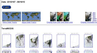
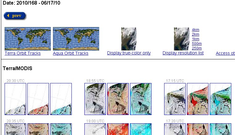
The two small maps show where the satellites were, or are predicted to be, on the day you access the page. Click on the Terra Orbit Tracks or Aqua Orbit Tracks map for a larger image.
.
.
.
Clicking on the Display true-color and false-color button gives you a page of thumbnails for rapid access to images from bands 1,4,3; 3,6,7; 7,2,1.
.
.
.
If you click on Display resolution list you get a page of thumbnails with lists of links showing all resolutions available for the day - usually a choice of 4, 2, 1, 0.5 or 0.25 km per pixel.

.
.
Arctic mosaic
Clicking Arctic mosaic in the Quick Links menu takes you to the current day's set of selected and adjusted images of the Arctic region.
The page comprises 36 separate images as a 6 x 6 display. The current day's display is posted on the fly, so it will have gaps for most of the day.
.

The Arctic mosaic images are made from selected parts of images from either Aqua or Terra. The selection and cut-and-paste methods provide the best overview of the Arctic area for the day.
Both satellite image sets are used, selectable via the View Aqua image and View Terra image links.
The image panels are laid out as a 6 x 6 row and column display. Columns are numbered left to right; rows are numbered bottom to top. Hovering the mouse over a panel will show its row and column numbers. Archived mosaic images include row and column numbers and can be retrieved directly by typing the url in your browser - once you are familiar with the filename conventions.
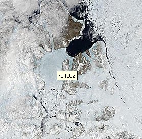
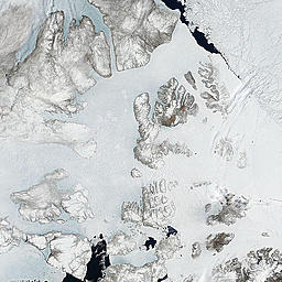
Row 4 column 2 - main part of North West Passage June 2010.
http://rapidfire.sci.gsfc.nasa.gov/subsets/?subset=Arctic_r04c02.2010168...
.
To retrieve an image for the same date in a previous year, change the url, e.g.
.http://rapidfire.sci.gsfc.nasa.gov/subsets/?subset=Arctic_r04c02.2009168.aqua
The date string in the url is the Julian day number, e.g. June 18 is day 169 Julian.
Caution: in a leap-year that would be day 170.
Row 4 column 2 - main part of North West Passage June 2009.
http://rapidfire.sci.gsfc.nasa.gov/subsets/?subset=Arctic_r04c02.2009168...
.
The two images above show as different sizes only because one is ascreen capture, the other a download. The MODIS images are exactly the same size.
Mosaics are not available for all years and dates. You need to experiment with the url and the 'prev - next' buttons.
Rapidfire Arctic mosaic sets are available in three pixel sizes:4km 2km 1km
Once you click on a specific row and column image, you get a choice of alternate pixel sizes:
4km | 2km | 1km | 500m | 250m
To retreive a specific image by date and resolution, append the required date and resolution to the mosaic url. e.g.
.http://rapidfire.sci.gsfc.nasa.gov/subsets/?mosaic=Arctic
.http://rapidfire.sci.gsfc.nasa.gov/subsets/?subset=Arctic_r03c03.2010169.terra
.http://rapidfire.sci.gsfc.nasa.gov/subsets/?subset=Arctic_r03c03.2010169.terra.250m
.
Downloading the Arctic mosaic
The Arctic mosaic can be downloaded as a single image in any available resolution. Just select the required resolution and then click Display the whole mosaic as a single image.
From there, right click and select 'save image', or use your prefered method to download the image. You will need a good web connection, these files are quite large!
To recover an older mosaic, adjust the url as noted above:
.http://rapidfire.sci.gsfc.nasa.gov/subsets/?mosaic=Arctic.2010169.terra.4km.jpg
.http://rapidfire.sci.gsfc.nasa.gov/subsets/?mosaic=Arctic.2009169.terra.4km.jpg
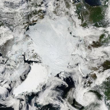
Arctic mosaic June 18 2010
http://rapidfire.sci.gsfc.nasa.gov/subsets/?mosaic=Arctic.2009169.terra....
.
Image quality
Rapidfire images are derived from scan strips 10 km wide and 2300 km long. Due to the optical path and the planet's curvature, the ends of the strips are significantly wider than the middle. Rapidfire calls this the bow-tie effect. The individual images are stitched together from multiple strips using Rapidfire's own software. The Aqua and Terra Near-real-time production images are not corrected for bow-tie distortions and artifacts.
Selected images are processed further, e.g. the Arctic mosaic sets.
The code we use to correct for the bow-tie effect and distortion is not
documented for distribution, but there are several free tools that will
give similar results. We recommend the MODIS Swath to Grid Toolkit (MS2GT), HDFLook, or HDF-EOS To GeoTIFF Conversion Tool (HEG).
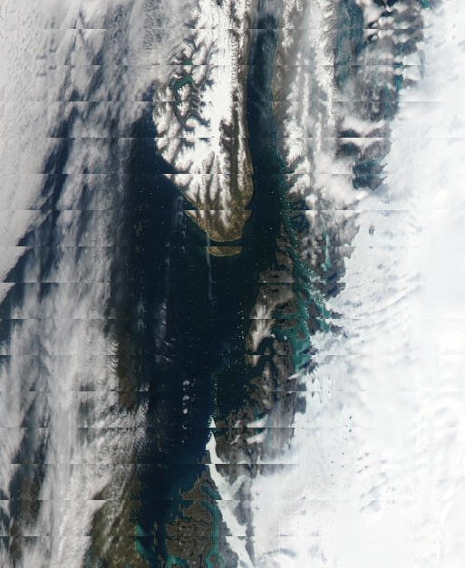
Bow-tie effect at left of image of an Aqua near real-time image, 250m resolution.
.
Near-real-time images are valuable if the area of interest is in the middle vertical part of the image. Especially so if the area of interest is at the join between two Arctic mosaic images, as shown here.
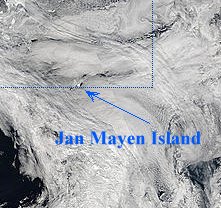
Jan Mayen Island in Arctic mosaic.
Jan Mayen Island lies between Iceland and Svalbard. It's potential climatic effect is out of proportion to its land area. It is of great interest in studies of Arctic sea ice and polynya formation.
.
The near-real-time images may have artifacts, but they are posted as soon as they are processed enough to display, so that - in my view - the convenience tends to outweigh the artifact problem.
Hovering over a thumbnail with the mouse causes a small globe to pop up, and a label is displayed briefly.
.
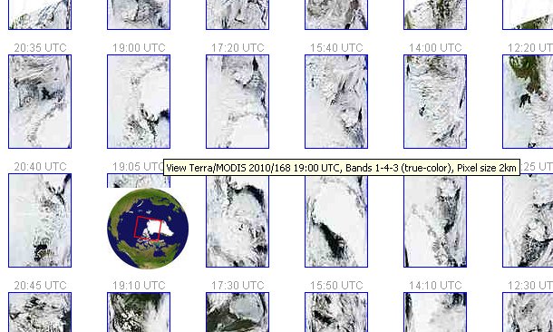
.
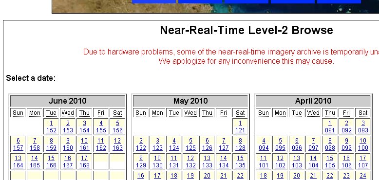
The Terra thumbnails are at the top, and the Aqua thumbnails below. To quickly access a few previous days worth of images, I use the 'prev' button at top left. To access other dates it is easier to click on Access other dates from the archive or the calender image. This displays a menu of all available archived Aqua and Terra images, going back to July 19 2002.
.
.
Access to LST images
Select one of the Aqua and Terra Near-real-time production images. By default it opens a new window. Options for different resolutions and bands are diplayed on the left.
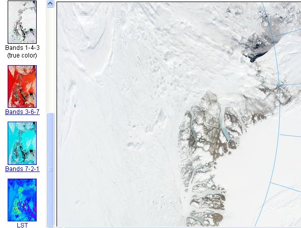
.
I shall give some hints about using the LST and other images in a later part of this series.
----------------------------------------------------------------------------------
Part 3 will contain hints and tips for analyzing the Rapidfire images, using the Arctic mosaic as an example.
A link will be posted here as soon as the next part is ready.
Meanwhile, here is a tease:
Kane Basin. Small features emphasised by image manipulation and animation.
I'll explain how this was done in the next part. The purpose is to show at a glance the difficulty of estimating ice volume.
Part #3 is now posted: MODIS Rapidfire For Citizen Scientists - #3
-----------------------------------------------------------------------------
Credit:
All images courtesy the U.S. taxpayer and NASA/GSFC, MODIS Rapid Response
http://rapidfire.sci.gsfc.nasa.gov/.


Comments