


NASA satellites obtained a number of different views of the great winter storm that left many snowfall records from Virginia to New York City from January 22 to 24, 2016. RapidScat provided a look at the strong winds that led to flooding in southern New Jersey, while NASA's Aqua satellite and NASA/USGS's Landsat satellite provided images of the post-storm snowy blanket.
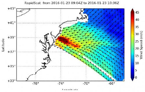
The RapidScat instrument flies aboard the International Space Station and measures surface winds over the ocean. On Jan. 23 at 5 a.m. EST, RapidScat showed sustained winds as strong as 45 meters per second (100 mph/162 kph) along the coast of southern New Jersey, which included areas from Cape May to Atlantic City. Those winds led to flooding along coastal areas.
After the storm had moved off into the Atlantic Ocean, NASA's Aqua satellite passed over the eastern U.S. The Moderate Resolution Imaging Spectroradiometer or MODIS instrument aboard captured a visible-light image on Jan. 24 at 1830 UTC (1:30 p.m. EST) that showed a blanket of snow on the ground stretching from southeastern Massachusetts to southeastern Missouri.
The Operational Land Imager (OLI) on Landsat 8 captured a natural-color image of Virginia, Maryland, and Washington, D.C. on January 24, 2016. Most neighborhoods in the image received at least 18 to 24 inches (46 to 61 centimeters) of snowfall from the nor'easter that pounded the region from January 22 to 24.
Some areas along the New Jersey coastline were flooded as winds pushed the ocean waters inland, and serious beach erosion was reported. Philadelphia's NBC Channel 10 interviewed the mayor of North Wildwood, New Jersey who said the flooding on the morning of Saturday, January 23 was half a foot higher than what the town experienced during Superstorm Sandy in 2012.
RapidScat is an important tool for meteorologists, because maximum sustained winds are not always equally distributed in a storm. RapidScat shows forecasters the location of the strongest winds in different quadrants of a storm, indicating locations facing greatest impacts.
Landsat 8 (formerly the Landsat Data Continuity Mission, LDCM) is a joint mission between NASA and the U.S. Geological Survey. It is collecting valuable data and imagery to be used in agriculture, education, business, science, and government. The Landsat Program provides repetitive acquisition of high resolution multispectral data of the Earth's surface on a global basis.
For NASA coverage of this historic storm, visit: http://www.nasa.gov/feature/goddard/2016/nasa-sees-major-winter-storm-headed-for-eastern-us


Comments