


Based on the trajectory and speed of the boats, CLS is acquiring data over the area skippers will be sailing into slightly ahead of their arrival time in order to monitor the metocean conditions.
Although skippers are forbidden to receive outside assistance in the Vendee Globe race, these data will be helpful for planning optimal routes in races where new types of meteorological information will be allowed.
"These innovative techniques providing wind and wave information at unprecedented resolution will certainly be directly transmitted to sailors in other races in the future to help them determine the most appropriate route in challenging regions of fast-changing metocean conditions such as the Canary Islands or the Saint Helene high pressure system," said Dr Fabrice Collard of France's CLS radar application division in Brest.
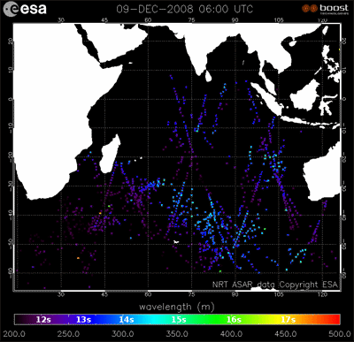
Global observation of swells in the Indian Ocean from Envisat Advanced Synthetic Aperture Radar (ASAR) wave mode. Colour indicating the swell wave length together with swell propagation speed and direction are all retrieved from near-real time Envisat ASAR wave mode level-2 products. Credits: ESA - CLS
These wind and wave product demonstrations, originally tested over Europe, are part of an ESA research project on innovative retrieval techniques. The development and processing techniques are being extended to Envisat Advanced Synthetic Aperture Radar (ASAR) data acquired along the Vendee Globe route.
The Vendee Globe takes sailors through severe wind and wave conditions in the Southern Ocean, which is also home to many icebergs. The data used in this test was originally acquired for the purpose of iceberg detection.
The long swells and high winds typical of the Southern Ocean have been clearly identified with a high-resolution variability that may provide new insight for the understanding of complex and remote seas.
As part of the Global Monitoring for Environment and Security (GMES), a joint initiative of the European Commission and ESA, ESA has undertaken the development of Sentinel-1 for the continuation of SAR operational applications.
Dr Vincent Kerbaol, head of the radar application division of CLS said: "This ESA and CLS research demonstration using Envisat data provides an excellent taste of the wind and wave products that will be delivered operationally to the GMES services using the next generation SAR onboard ESA’s Sentinel-1 satellite to enhance the maritime safety and awareness."


Comments