


Scientists have measured the difference in gravitational attraction from the surface of the Earth, but a new mission to be launched by the European Space Agency in March will measure the gravitational force over the surface of the Earth using a unique satellite - one that has no moving parts and sports airplane-like wings.
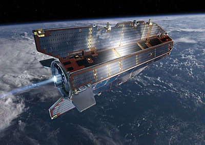
Winged Satellite: The ESA's GOCE satellite will fly in the upper atmosphere, necessitating large, stabilizing fins. Photo Credit: ESA
The GOCE satellite looks like a big flying dart - it's a large octagonal prism whose leading face points into a blunt nose and has two large symmetrical solar panels fixed perpendicular to the top and bottom, as well as two small horizontal stabilizers. The reason GOCE needs all of its aerodynamic features is that it will fly at a low 250 km above the surface of the Earth - lower than most Earth orbiting satellites, including the International Space Station. To accurately read the gravitational field from space, GOCE needs an extreme amount of stability as well as a strong gravitational signal. The fins will assist in stabilizing the spacecraft's attitude and will help it make readings at the necessarily low altitude.
The new satellite will measure the height of the geoid - a surface of equal gravitational force that dips above and below the Earth's physical surface. Say you take a one-pound weight, and you walk along the surface of the Earth. If the density of the ground underneath you begins to increase, the gravitational force will increase and the weight will get heavier. To counteract this, you raise the weight up higher - therefore reducing gravity's influence. If, as you walk along, you continue to adjust the height of the weight so that it always weighs one pound, you will be following the surface of the geoid.
A major consequence of the geoid not following the physical surface of the Earth is that it can determine ocean currents. Water will flow along a perfectly flat surface if there is a region of higher density somewhere (which causes a change in the geoid), and the mapping of Earth's geoid can help climatologists determine ocean patterns. Also, since the geoid effectively determines where the horizontal is, leveling ground for building projects will become more accurate.
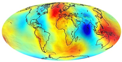
Old Geoid: A visual representation of the old geoid model. Different colors correspond to different heights of the geoid. GOCE will increase the accuracy of previously-taken ground-based measurements. Photo Credit: ESA
To measure these minute changes in gravitation, GOCE uses three orthogonal sensors. Each sensor has a mass on either end that moves based on an external acceleration. A difference in motion between two masses on the same axis indicates how the geoid is changing beneath the satellite. Obviously, any small acceleration will be read by the accelerometers, so the spacecraft itself has to be very stable and know its own position very well. To keep vibration and other motion out of the spacecraft, GOCE was engineered to have no moving parts and no deployable appendages - two rare characteristics of a spacecraft. Pointing control, commonly achieved using wheels that exchange momentum with the spacecraft by spinning, uses magnetic torquers: long rods with coils of wire that use electricity to create a magnetic field that interacts with the Earth's. All the solar panels are body-mounted and fixed, so that they don't need to be attached to the spacecraft through hinges that may flex.
In addition to helping monitor ocean currents, mapping the geoid will give scientists a better understanding of how the Earth's crust is composed and may provide information about deposits of petroleum for drilling. GOCE is only the first of a series of satellites the ESA plans to launch called the Earth Explorers, all of which will demonstrate new technology in space as well as provide data to scientists. Up next, in 2010 and 2013, two new satellites will measure vertical wind profiles in the upper atmosphere and the exhange of heat between the sun and the Earth, both of which will lead to an unprecedented understanding of the planet.


Comments