


Super Typhoon Usagi and its 150 MPH winds will be the strongest weather event this year.
The radar on the Tropical Rainfall Measuring Mission (TRMM) satellite captured an image of Supertyphoon Usagi near the end of a 24-hour period in which Usagi intensified by 65 knots. This is more than twice the commonly used 30-knot threshold for defining rapid intensification. The TRMM data was used to create a 3-D image. The data was collected at 1035 UTC/6:35 a.m. EDT on Thursday, September 19, 2013, when Usagi was at category 3 on the Saffir-Simpson hurricane intensity scale.
A few hours later, Usagi completed its lightning-fast intensification to category 5, the highest category in the scale. While the center of this tropical cyclone is forecast to past just south of Taiwan in a few days, some forecasts have it striking Hong Kong a few days after that.
TRMM's Precipitation Radar can provide 3-D vertical profiles of rain and snow from the surface up to a height of about 12 miles/20 kilometers. TRMM's 3-D view of the vertical structure near Usagi's eye found that the violent storms in Usagi's eye wall were consistently reaching heights of over 15 km/~9.3 miles. A few storms found in a feeder band spiraling into Usagi from the south were reaching even higher heights of over 16 km/~9.9 miles.
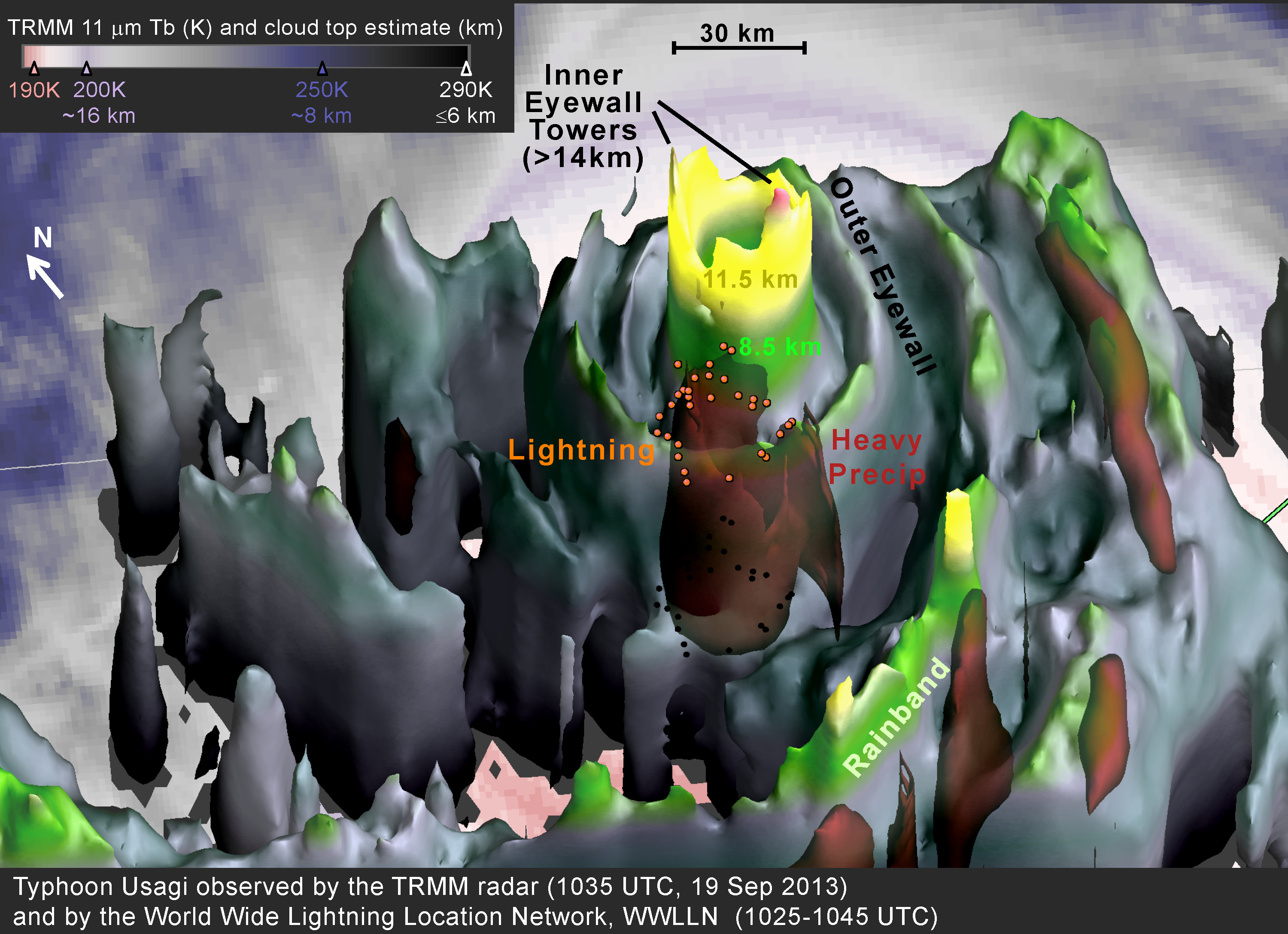
This TRMM 3-D image of Super-Typhoon Usagi on Sept. 19 shows heavy rain (red) at the base of the eyewall. The lightning flashes (ring of small orange dots) are displayed at 5 km altitude. That's near the freezing level in tropical cyclones and near the top of the heavy precipitation.
Image Credit: NASA/Owen Kelley
Radars almost always see eyewalls in strong tropical cyclones, but few tropical cyclones have such symmetric eyewalls as does Supertyphoon Usagi in the TRMM 3-D image.
After the TRMM satellite captured rainfall, NASA's Aqua satellite passed over the Super-Typhoon. The Atmospheric Infrared Sounder or AIRS instrument that flies aboard NASA's Aqua satellite captured an infrared image at 17:29 UTC/1:29 p.m. EDT that also clearly showed a pinpoint eye. AIRS measured cloud-top temperatures to determine cloud heights, which also indicate strength. Cloud top temperatures were as cold as 210 kelvin/ -81.6F/-63.1C, indicating very high, very powerful thunderstorms with heavy rainfall potential.
Strong thunderstorms with heavy rain were over northern Luzon, Philippines at the time of the image. Infrared data on Sept. 20 revealed that convection (rising air that forms the thunderstorms that make up the tropical cyclone) in the northern quadrant were decaying, or weakening.
Satellite data also showed that Usagi was undergoing eyewall replacement on Sept. 20, which is typical for very powerful typhoons or hurricanes.
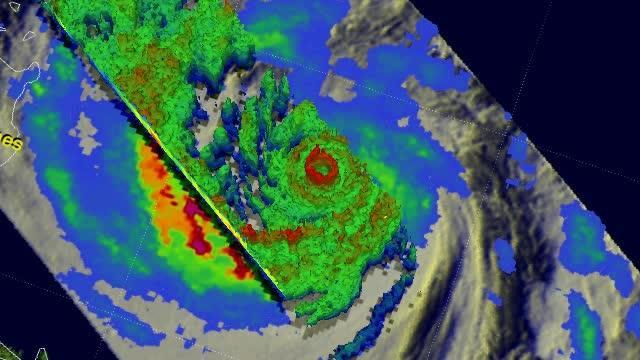
In this TRMM satellite flyover animation from Sept. 19 rain was falling at a rate of over 140mm/~5.5 inches (red) per hour in the powerful storms within Super Typhoon Usagi's eye wall. Credit: NASA/SSAI, Hal Pierce
There are warnings in effect in Taiwan, the northern Philippines and China. Typhoon Warnings are up for Taiwan, especially for southeastern and southwestern areas as Usagi is forecast to move south of the island. In the Philippines, warnings and watches were posted for the northern provinces of the Philippines that include flash flooding, heavy rain, landslides and storm surges.
In China, the China Meteorological Administration or CMA issued an orange alert. The CMA's website noted that Usagi is expected to move across Bashi Channel at noon (local time) on Sept. 20 then enter northeastern South China Sea to approach coastal Guangdong.
On Sept. 20 at 1500 UTC/11 a.m. EDT, Usagi's maximum sustained winds dropped to 130 knots/149 mph/241 kph. The center of the storm was located near 20.3 north and 123.2 east, about 324 nautical miles south-southeast of Taipei, Taiwan. Super-Typhoon Usagi is moving to the west-northwest at 9 knots/10.3 mph/16.6 kph.
The latest Joint Typhoon Warning Center forecast projects that Usagi will pass north of the Philippines in the next couple days and then pass very close to the southern tip of Taiwan on September 21. This path exposes southern Taiwan to the most dangerous part of the typhoon.
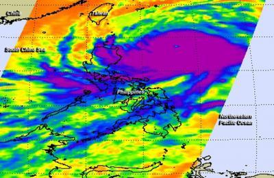
The AIRS instrument aboard NASA's Aqua satellite captured this infrared image of Super-Typhoon Usagi on Sept. 19 at 17:29 UTC/1:29 p.m. EDT, showing a pinpoint eye. Strong thunderstorms with heavy rain (purple) were over northern Luzon, Philippines at that time. Photo Credit: NASA/AIRS, Ed Olsen


Comments