CryoSat carries a radar altimeter that can ‘see’ through clouds and in the dark, providing continuous measurements over areas like central Antarctica that are prone to bad weather and long periods of darkness. The radar measures the surface height variation of ice by timing the interval between the transmission and reception of very short radar pulses as the satellite orbits Earth. CryoSat collects data over Antarctica while passing on northbound and southbound orbits.
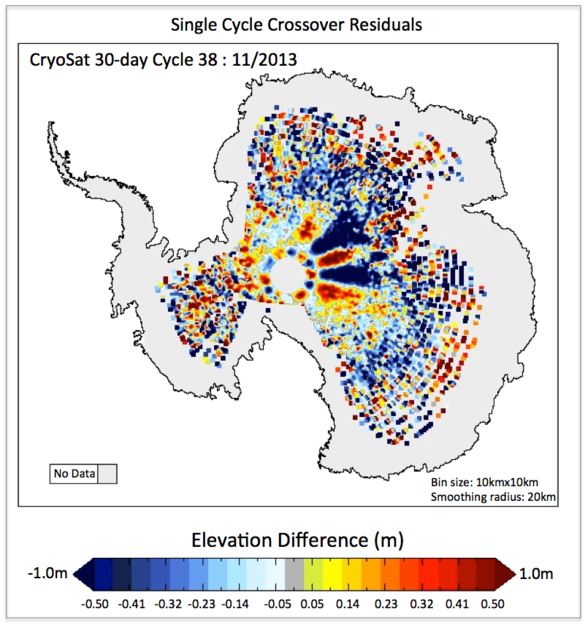
But the data show an unusual pattern of height differences where these orbit cross, radiating from the South Pole.

Elevation differences in Antarctica as measured by CryoSat in November 2013. There is a distinct pattern of alternating high and low elevations (shown in red and blue), which inverts closer to the South Pole. After careful analysis, it was discovered that this is an artefact caused by the interaction of the polarisation of CryoSat’s antenna with the structure of the ice. Credit: ESA/MSSL
“When this static pattern in the CryoSat measurements emerged, alarm bells started to ring,” said Tom Armitage from University College London, who led the study. “At first, we thought that there could be an issue with the satellite itself, such as a miscalculation of the altitude, a timing error or a problem with one of the corrections we apply to the measurements.”
After eliminating the possibility of these errors, they discovered that the pattern was caused by the way the satellite signal is scattered from the ice sheet surface. Antarctica has some of the strongest and most persistent winds on Earth, which leave permanent erosional and depositional features on the surface and in the snow pack. The scientists found that that these wind-driven features modify CryoSat’s radar measurements in such a way as to produce the pattern that has been detected.
“The pattern is not an ‘error’, but an artefact arising from the interaction of the polarisation of CryoSat’s antenna with the structure of the ice surface induced by wind,” said Tommaso Parrinello, CryoSat Mission Manager.
Wind-driven directional properties of the ice sheet surface can affect the signal received by radar altimeters, but it has never been seen so clearly. The most striking feature of the pattern – the diamond ring pattern close to the pole – had not been seen by past altimeter missions because they did not fly far enough south.
The pattern is stable over time so the data can easily be corrected, ensuring that CryoSat’s past and future measurements of Antarctica are precise. The discovery also helps scientists better understand the interaction between radar waves and ice sheet surfaces.
Citation: Armitage, T.W.K., Wingham, D.J., Ridout, A.L., 'Meteorological Origin of the Static Crossover Pattern Present in Low-Resolution-Mode CryoSat-2 Data Over Central Antarctica', Geoscience and Remote Sensing, DOI:10.1109/LGRS.2013.2292821


Comments