Banner
Air India Flight 171 - Flawed EE Bay Water Ingress Theory

Air India Flight 171 - Flawed EE Bay Water Ingress TheoryRichard Godfrey, in many videos on the...

Air India Flight 171 Accident Summary - Key Findings

Air India Flight 171 Accident Summary - Key FindingsThe purpose of an air accident report is to...

Air India Flight 171 - Ask The experts

Air India Flight 171 - Ask The expertsAn open letter to H. Lawrence Culp, Jr., Chairman and Chief...

Air India Flight 171 - The Vital Seconds

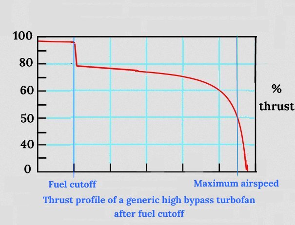
Air India Flight 171 - The Vital SecondsThe Timeline - Vital Seconds.This timeline is constructed...

User picture.
picture for Hank Campbellpicture for Fred Phillipspicture for Hontas Farmerpicture for Tommaso Dorigopicture for Robert H Olleypicture for Helen Barratt
Patrick LockerbyRSS Feed of this column.

Retired engineer, 79 years young. Computer builder and programmer. Linguist specialising in technical translation. Interested in every human endeavour except the scrooge theory of accountancy. Interested... Read More »

Blogroll
Arctic Ice 2011 - Sail, Steam and Satellites

The NSIDC will shortly be publishing its report for March 2011.  I expect the report to conclude that Arctic sea ice extent for February 2011 was the 'lowest in the satellite record'.  That would mean the 'lowest ever recorded in human history', since we have abundant data on historic ice extent.

There is a false argument doing the rounds of the blogs: words to the effect that we have no accurate knowledge of ice extent before the age of satellites.  This is, of course, nonsense on stilts in clown boots with a squirting flower - the latter being filled with complete and utter bilge with an admixture of absolute hogwash.
Ross Ice Shelf - Some Observations

The Ross Ice Shelf is the largest ice shelf in the world with an area of roughly 182,000 square miles - 472,000 square kilometers.  The shelf  was named after Captain James Clark Ross who discovered it  January 28th, 1841.  The coast to which the ice shelf is attached reaches nearer to the south geographic pole than any other part of Antarctica's coast.


Image source: NASA/MODIS Antarctic mosaic.
All At Sea With The Vikings

The Vikings had an expression - hafvilla - which indicates a state of being at sea and having no sense of direction.  There are two modern English phrases that cover this situation: 'all at sea', and 'without a clue'.


In order to more fully understand the Viking sagas we must learn, not what the Old Norse words mean as translated multiple times down the ages, but what the original words meant to a Viking.

North and South
George Best - An Elizabethan Climate Scientist

whosoeuer could finde out in what proportion the Angle of the Sunne beames heateth, and what encrease the Sunnes continuance doeth adde thereunto, it might expresly be set downe, what force of heat and cold is in all regions.
George Best, written between 1578 and 1584.


Image courtesy NASA: http://researchpark.arc.nasa.gov/...
I'm Back - With an Apology

I have been absent from science20.com for some time due to illness.  I apologize for not reponding to the many comments and emails I have received in my absence.
A Waymark Called Hvitsark


The Vikings did not use charts and instruments to navigate the open seas.  Having developed skills in coastal navigation they extended those skills to pelagic navigation, or 'island-hopping'.  Using the sun as a reference to determine where south lies, the Vikings could sail a reasonably accurate course.  If the wind was steady, the wind itself could be used as an aid to direction if the sun was hidden by heavy cloud.  It was only when wind and sun both failed the navigator that he was likely to miss his mark.


A Viking ship sailing on a beam reach.
Screenshot from The Vikings, 1958.