


If you looked at the "Black Marble" images of Earth at night released by NASA and the National Oceanic and Atmospheric Administration this week, you may have noticed bright areas in the largely uninhabited western part of Australia.
What's the story?
The night light observed by the Suomi NPP satellite images comes from wildfires. In those bright areas of western Australia, there are no nearby cities or industrial sites but there were fires in the area when Suomi NPP made passes over the region.
The extent of the night lights in this area is also a function of composite imaging. The new images were assembled from data acquired over nine days in April and 13 days in October. This means fires and other lighting (such as ships) could have been detected on any one day and integrated into the composite picture, despite being temporary phenomena.
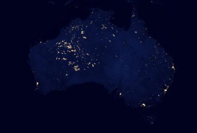
This nighttime image of Australia was cropped from the Suomi NPP "Black Marble" released by NASA and the National Oceanic and Atmospheric Administration in December 2012. Credit: NASA Earth Observatory/NOAA NGDC
Because different areas burned at different times when the satellite passed over, the cumulative result in the composite view gives the appearance of a massive blaze. These fires are temporary features, in contrast to cities which are always there.
Other features appearing in uninhabited areas in these images could include fishing boats, gas flaring, lightning, oil drilling, or mining operations, which can show up as points of light. One example is natural gas drilling in the Bakken Formation in North Dakota.


Comments