


Yesterday, a monster tornado almost 2-miles wide tore through Moore, Oklahoma, a suburb of Oklahoma City, wiping out entire blocks and killing 24 people.
The National Weather Service upgraded its calculation of the storm's strength today, declaring it was a rare EF5, the most powerful ranking on the Enhanced Fujita Scale, and had winds exceeding 200 miles per hour and left a trail of destruction measuring about 17 miles long. Debris from the tornado fell as far as 100 miles away, reaching the city of Tulsa.
Starting tomorrow, BusinessWeek, Mother Jones and others will find a way to blame global warming, but until then we have NASA to just show us what was happening. The Aqua satellite captured a visible-light image that provided a detailed look at the supercell thunderstorm. NOAA's GOES-13 satellite provided continuously updated satellite imagery depicting the storm's movement. After the tornado, the NASA-NOAA Suomi National Polar-orbiting Partnership satellite's lightning observations showed that the thunderstorm complex was still active after nightfall.
NOAA's GOES-13 satellite provided forecasters with images of the storm system every 15 minutes. One GOES-13 satellite image was captured at 19:55 UTC (2:55 p.m. CDT) as the tornado began its deadly swath. The tornado was generated near the bottom of a line of clouds resembling an exclamation mark.
The GOES-13 satellite imagery from the entire day was assembled into an animation by the NASA GOES Project at NASA's Goddard Space Flight Center in Greenbelt, Md.
NOAA's GOES-13 satellite shows the movement of storm systems in the south central United States on May 20, 2013. Warm, moist gulf air flowing across Texas, Oklahoma, Kansas and Missouri triggered tornadoes, with an F-4 tornado (winds between 166 and 200 mph) crossing Moore, Okla., on May 20 around 3 p.m. CDT. Credit: NASA/NOAA GOES Project
Four minutes after the tornado dissipated (19:40 UTC / 3:40 p.m. EDT), the Moderate Resolution Imaging Spectroradiometer (MODIS) instrument aboard NASA's Aqua satellite captured a visible image of the supercell thunderstorm that spawned the Moore tornado. That image was created by the NASA Goddard MODIS Rapid Response Team and Adam Voiland, NASA Earth Observatory.
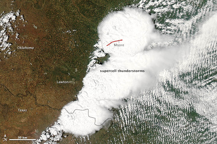
The Moderate Resolution Imaging Spectroradiometer (MODIS) on NASA's Aqua satellite acquired this image of the storm at 2:40 p.m. local time (19:40 UTC). The red line depicts the tornado's track. The twister touched down west of Newcastle at 2:56 p.m. and moved northeast toward Moore, where it caused dozens of deaths and widespread destruction. The tornado had dissipated by 3:36 p.m., after traveling approximately 20 miles (32 kilometers).
Credit: NASA/Jeff Schmaltz, LANCE/EOSDIS MODIS Rapid Response Team at NASA Goddard; caption by Adam Voiland
Later as the storm system continued through the region, another satellite captured an image of the storm at night that showed it was still powerful. The Visible Infrared Imaging Radiometer Suite aboard Suomi NPP observed lightning in a nighttime image on May 21 at 07:27 UTC (3:27 a.m. EDT). Lightning appeared as rectangular shapes in the image. The VIIRS imagery showed the city lights in the Oklahoma City area, but there was reduced light output in Moore as a result of tornado damage.
The Suomi NPP satellite carries an instrument so sensitive to low light levels that it can detect lightning in the middle of the night. The Day/Night band on Suomi NPP produces nighttime visible imagery using illumination from natural (the moon, forest fires) and man-made sources (city lights). The data were captured by the direct broadcast antenna at University of Wisconsin.


Comments