

"Based on the available data regarding the location of the lost aircraft, weather is a factor in the triggering of the incident. The most likely weather phenomenon is cooling air which can cause engine damage due to icing. This is just one of the possibilities that arise based on the analysis of available meteorological data, and is not a final decision about the cause of the incident."
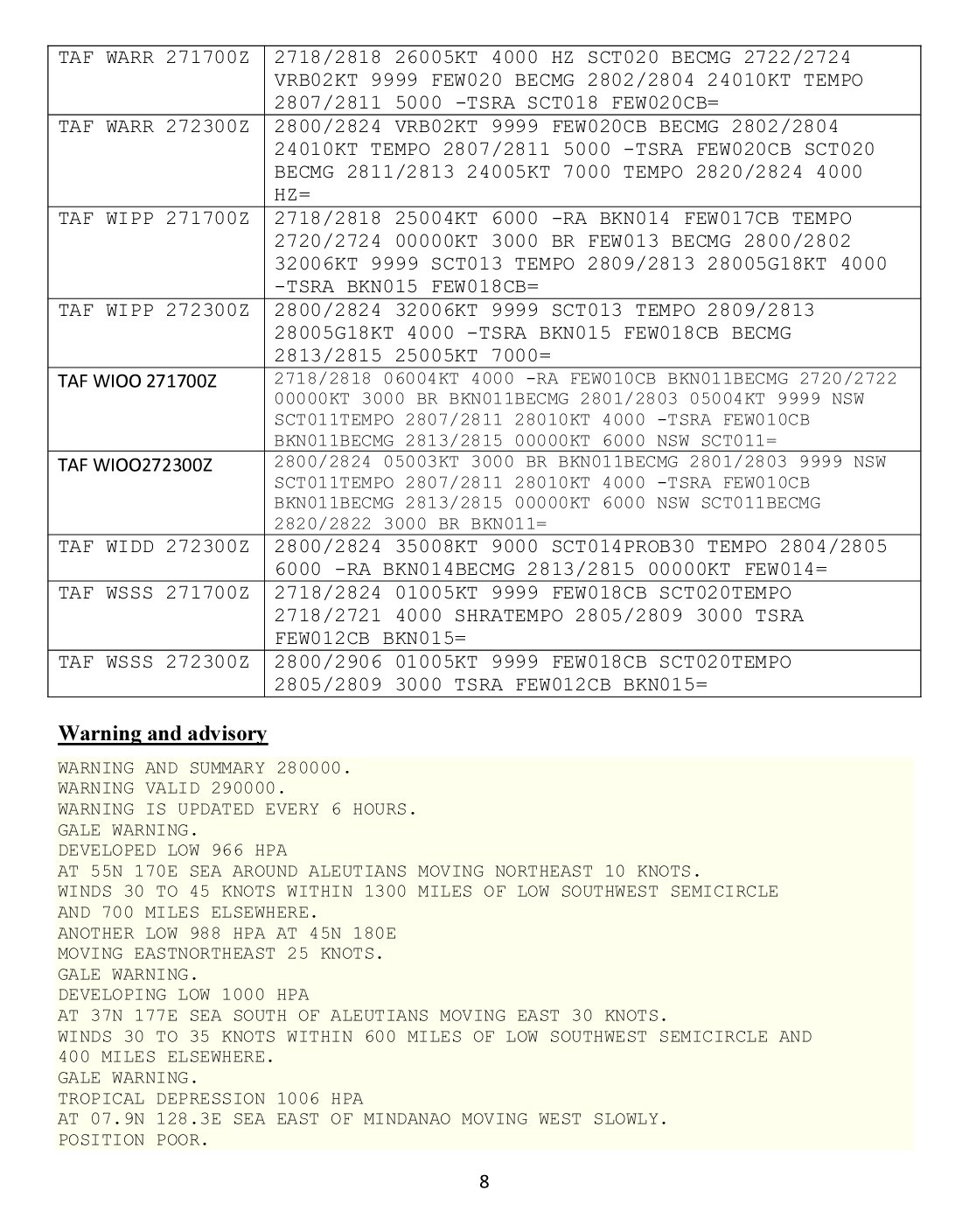
From the BMKG weather report, in full below.
Facts and Fiction
Whenever there is a major air incident rumours and guesses tend to fly around the world faster than facts. In this age of instant communication it is becoming ever harder to sort fact from fiction. Fortunately, a training in science or engineering provides the tools needed to sort out the fact from the fiction. Also, the scientist and the engineer know where best to seek out facts: from professionals who are directly associated with the event or professionals who are familiar with aviation technology and/or accident investigation techniques. As to the media, again generally speaking, it is best to rely on news outlets which cite named sources. The proverbial "un-named source" may be making wild guesses, may have a pet theory (pilot error / pitot error) or may even have a personal axe to grind. The search for truth needs to be as planned and methodical as the search for the black boxes.
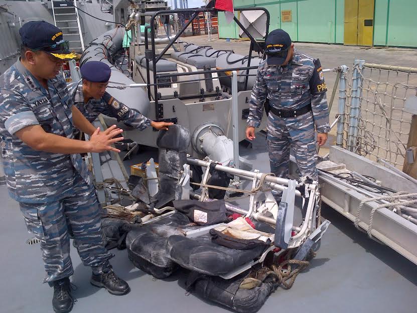
The Evacuation Slides
It is clear from reliable sources such as Detik News and BBC Indonesia, from images of recovered wreckage and from the distribution of bodies and wreckage that the plane was broken apart by strong forces. It is impossible at this stage for a distant observer to say whether the plane broke apart in the air or on impact with the sea. A recent report from Detik News suggests that the plane did not break up in the air, but crashed in the sea due to icing, but no source is cited for that information. Aviation Herald also reports "the aircraft was believed to have impacted water". The author concurs: images he has seen which are far too graphic to post here suggest water impact.
What is virtually certain is that, contrary to many reports, the plane did not ditch in any meaningful sense. The recovered deployed evacuation slides do not furnish evidence of attempted evacuation. Fact: one slide was hauled with difficulty by a team of men. Fact: an unpacked slide can usually be hauled by one man - two at most. Fact: the inflation mechanism uses the venturi effect to draw in air as gas is injected into the slide. Fact: if the air inlet valve is underwater, water will be drawn in. Broken fittings and the fairly obvious presence of water in at least one slide indicates slide deployment on impact with, or under, the water.
Route Permits
There is a world of difference between a permit or licence for an airline to operate and permission to fly a specific plane at a specific time. Indonesia Air Asia did not have a permit to fly the route on Sundays. It is not incumbent on an employee, in this case the pilot, to ask if a long-established corporation has the necessary permits to do business. The pilot would not ask his employers if they had a permit for the route in the same way that an insurance salesman would not ask his employers if they held a licence to sell insurance.
If the lack of a route permit is a relevant factor in the loss of flight 8501 it can only relate to traffic density. If there was no Sunday permit because the route was already congested then it may be that the one extra plane in the sky was the proverbial 'last straw'. The ATC controllers concerned are already handling a very high volume of traffic.
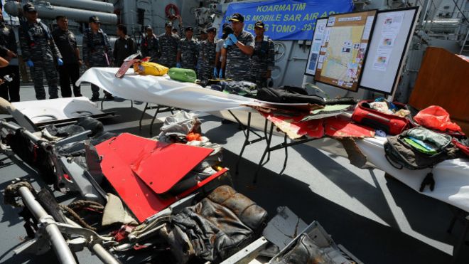
image source BBC Indonesia
Weather
It is virtually certain the the plane was brought down in some way by severe weather. In just one of many possible scenarios the plane could have been caught in a sudden updraught followed by a suddenly encountered downdraught. Actions taken by the flight crew to maintain control in the updraught could have proved impossible to cancel or reverse in a downdraught. Ice may be a factor, as in loss of engine power and/or an increase in aircraft mass. Perhaps there was icing together with an updraught/downdraught scenario. Until a full analysis is carried out by experts this scenario must be treated as speculative.
That said, the weather conditions of the time and place are known to a high degree of certainty. Below is a report issued by BMKG - Badan Meteorologi, Klimatologi dan Geofisika - The Meteorolgy, Climatology and Geophysics Agency. BMKG and the authors own the copyright and deserve the full credit for this scientific paper. Any typos, errors of translation or omissions are entirely mine.
Please note that I have not translated the tables and weather maps. Unfortunately my knowledge of meteorology is inadequate to the task, however, the images should be intelligible to everyone who has the relevant expertise.
Source:
Kecelakaan Airasia QZ 8501 Analisis Meteorologis
Prof. Edvin Aldrian, Ferdika Amsal, Jose Rizal,Kadarsah
Translation begins >>
AIRASIA QZ 8501 ACCIDENT
Meteorological Analysis
By: Prof. Edvin Aidrian, Ferdika Proverbs, Jose Rizal, Kadarsah
I. Introduction
Air Asia flight number QZ 8501 flew from Juanda International Airport in Surabaya, East Java, destination Changi International Airport in Singapore, the flight employing an Airbus A320-200 aircraft type which carries 161 passengers. The plane lost contact around the area of the Karimata Strait on the morning of December 28, 2014.
The aircraft, registered PK-AXC lost contact while in the airway M635, between waypoints TAVIP and RAFIS, that is: between Tanjung Pandan (East Pacific Islands) and Pontianak. The aircraft was last in contact with ATC at Soekarno-Hatta Airport at 6:12 pm. The plane was last observed at an altitude of 32,000 feet above sea level before the ADS-B (Automatic Dependent Surveillance Broadcast) signal was lost.
When the plane reported that to avoid Cumulonimbus clouds (Cb) it needed to turn to the left, the altitude was 32,000 feet and permission was sought to increase the aircraft's altitude to 38,000 feet. Then at 6:17 pm, the plane lost contact.
Preliminary analysis indicates that the aircraft may have flown into storm clouds. A similar incident has happened before. Some examples follow of aircraft accidents occuring due to weather factors. On January 16, 2002, around 0920 UTC, Garuda Indonesia Airlines Flight 421, a Boeing 737-300 with registration PK-GWA experienced dual-engine fiameout (power loss) as a result of trying to avoid storm clouds. Then Adam Air flight 574 (KI 574, 574 DHI) Jakarta-Surabaya-Manado on January 1, 2007 suffered damage to Inertial Reference System (IRS) - navigational aids - due to bad weather, and just days before the crash of Air Asia QZ8501 a Singapore Airlines A330-300 registration 9V-type SSD, flight number SQ-615, carrying 268 passengers and 13 crew experienced severe turbulence levels while making regular flights on December 22, 2014 from Osaka (Japan) to Singapore. The incident occurred at an altitude of 39,000 feet above the South China Sea (QNE), approximately 200 NM north-west town Bandan Seri Begawan (Brunei) at 03:10 local time or 19:10 UTC.
It is interesting to observe that a plane crash survey released by the International Civil Aviation Organization (ICAO) shows that in the last 10 years the chance of a plane crash during cruise was statistically small. Accidents in level cruise are due to sabotage, hijack or being shot down by a missile from the ground.

Figure 1. Percentage of aircraft accidents according to ICAO
So the purpose of this study was to identify the relationship of the accident to Air Asia flight number QZ 8501 with hurricane activity that occurred in the Karimata Strait.
II. The data
A. Chronological Event Data
The plane took off from runway 10 at Juanda International Airport (SUB) at 05:35 local time (22:35 UTC). After takeoff the plane turned left 329° at the top of the Java Sea. At 5:54 Lt altitude reached was FL320. The plane then changed direction to the left to 319°. 10 minutes later there was another slight change in the direction to 310 °. The aircraft was last seen on the ACC radar screen at 6:24 pm or 23:24 UTC. At that time the aircraft was deviating (from the airway) as had been planned for reasons of bad weather. The aircraft sought permission to ascend to a height of 38,000 feet from 32,000 feet. And several times changes of heading were carried out by the aircraft as is expected due to the block of bad weather in front of it. It is estimated that AWQ-8501 / QZ-8501 was unavoidably trapped in bad weather when it was over the Karimata Strait near Belitung Island. At 7:08 pm, the plane was tagged INCERFA (uncertainty emergency phase), at 7:28 pm, the plane was tagged ALERFA (alert emergency phase) and then at 7:55 pm, the plane was tagged DISTRESFA (distress emergency phase).
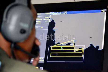
In the final seconds the aircraft disappeared from the radar screen, it appears that the aircraft has deviated to the left of its planned path as depicted below.
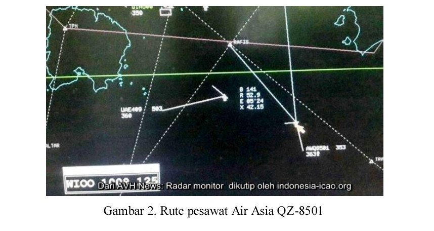
Figure 2. Radar Plot Air Asia QZ-8501
The plane marked AWQ-8501/QZ-8501 seems to veer towards the left and has left an altitude of 32,000 feet and is rising to the height of 36,300 feet while the speed decreased to 353Kts. Based on the image data from the radar monitor visible at the same time, in addition to QZ8SOI there are also other aircraft: Emirates airline flight number UAE-409 flying a regular route from YMML / MEL (Melbourne, Australia) to WMKK / KUL (Kuala Lumpur). At that time the UAE-409 aircraft which also departed MEL on the same day at 4:10 pm and arrived at the KUL at 08:22 pm is located to the front left of the path of QZ-8501 with a height of 36,000 feet and a speed of 503 kts.
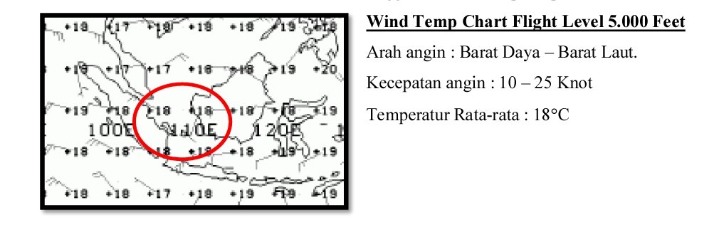
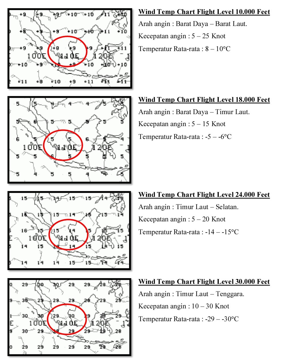
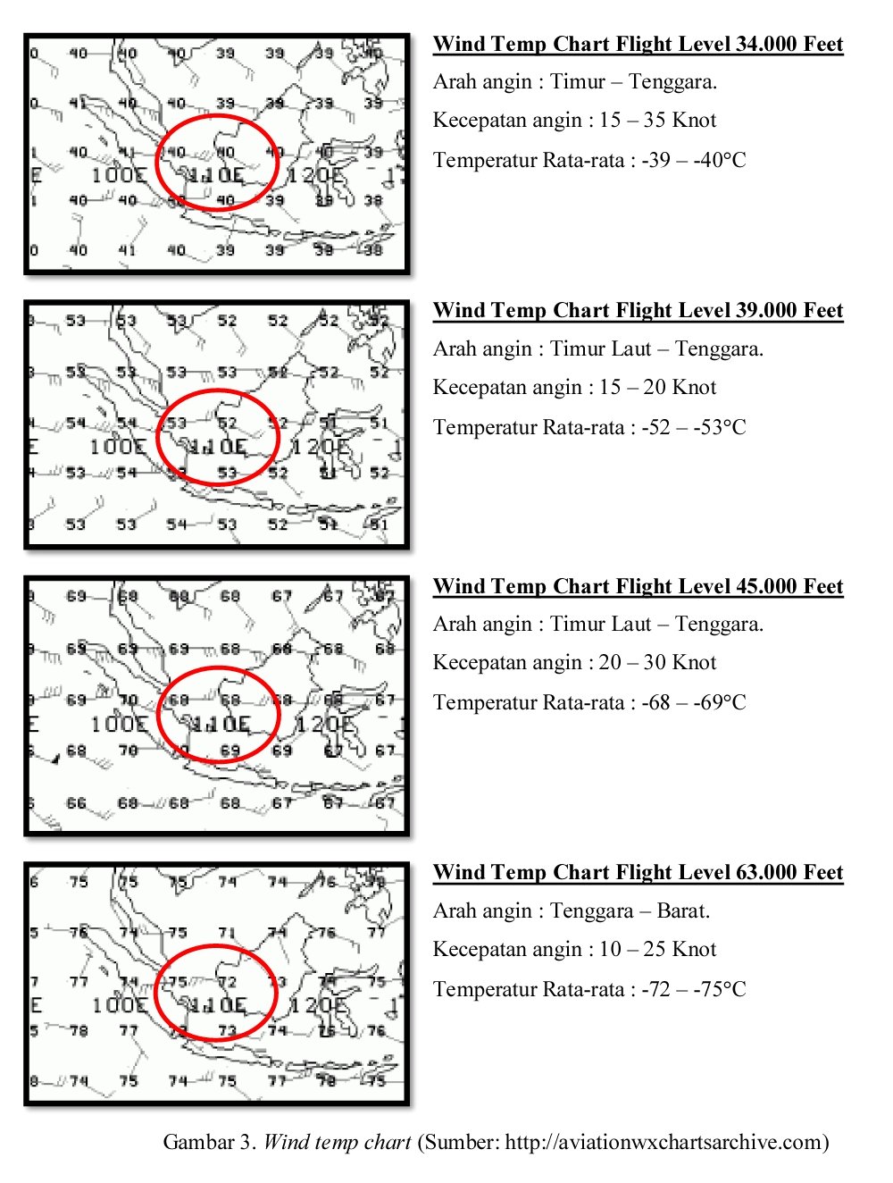
In general, the weather conditions at the origin and destination airports showed no significant weather conditions, it was possible to take off and land aircraft. But we can see that the weather conditions as given in the documents provided to the airline's office by BMKG indicate that the route that will be travelled during cruising flight levels are quite alarming condition. This can be seen from the SIGWX data and satellite image provided during the pilot briefing before flying, as shown in Figure 3 [charts below] and the data which follows.

III. Analysis of Events
In general, we can analyze the form of regional-scale weather disturbances when the incident to Air Asia QZ 8501 occurred. Convectivity is a condition that occurs routinely around the region where the plane crashed as happened in recent months, when the Inter Tropical Convergence Zone (ITCZ ) migrated south during the summer in the southern hemisphere. The presence of sea surface temperatures warm enough along with an abundance of wet air masses in the western part of Indonesia helped to create a favorable environment for the growth of storm clouds on a large scale.
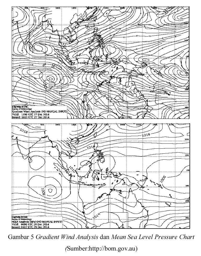
Figure 5 Wind Gradient Analysis and Mean Sea Level Pressure Chart
(Source: http://bom.gov.au)
.
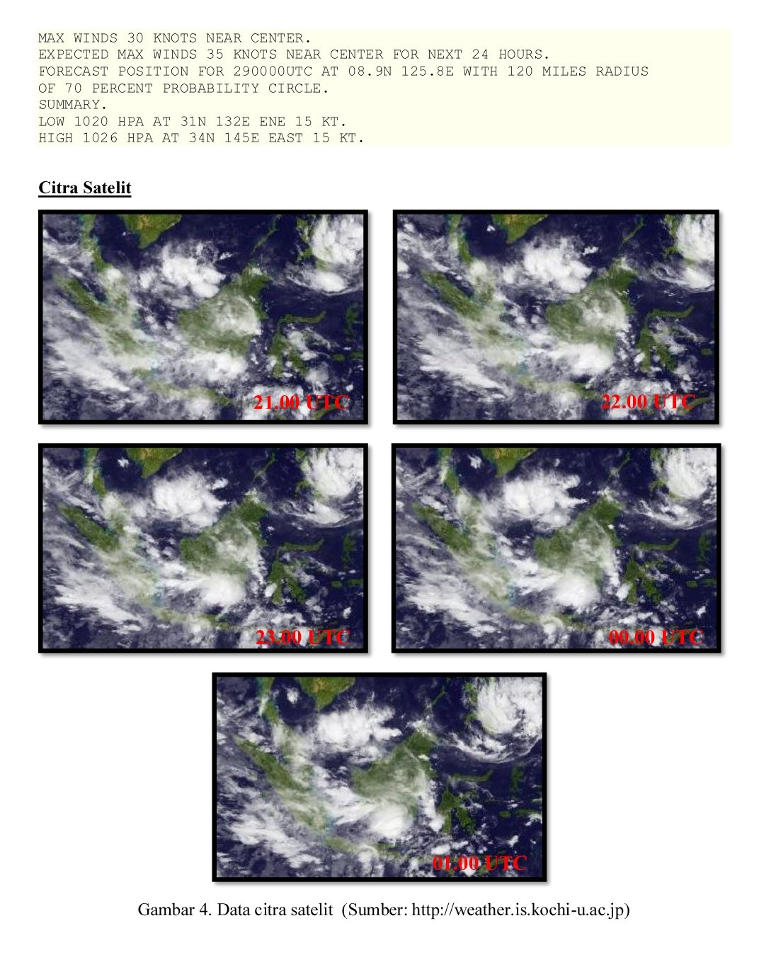
Analysis of these events was performed using the map on the SSEC RealEarth server, by combining the regional maps and MTSAT-2 10.8 μm IR (Infra Red) at 23:00 UTC as shown in Figure 6. Satellite images show that there was a group of convective clouds on the flight path that was passed.
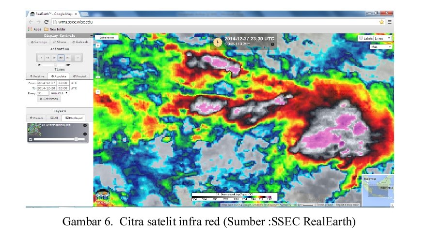
Figure 6. Infrared Satellite Imagery (Source: SSEC RealEarth)
At the time of the incident IR satellite imagery reveals that the temperature of the cloud tops reached -80° s/d -85° C (violet), which means there were grains of ice in the cloud. By using satellite imagery Vis (visible, Figure 7). we get clearer information identifying existing convective clouds on the flight path that was traversed by Air Asia QZ 8501. It also shows evidence that there were several towering cloud peaks on the traversed flight path.
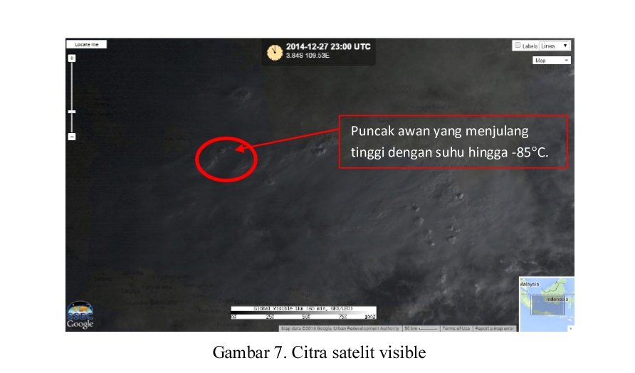
Figure 7. Satellite images, visible
Upper air data obtained during the incident and the meteorological station Louth indicate that the aircraft at cruising altitude of 32,000 feet or can be converted approximately 300 hPa (9750 meter above ground level), Udana around the observed temperature at that height is -29.3 ° C and the wind was blowing from the southwest at a speed of 16 knots. Height of the tropopause layer is observed around 100 hPa (at an altitude of 54 265 feet or 1,654 1cm), with air temperature -86.5 ° C peak temperature approaching clouds obtained from IR satellite imagery.
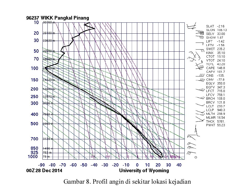
Figure 8. Profile of winds in the area
Upper air analysis (Figure 8) showed that the dry conditions in the bottom layer (1000-800 Mb) do not support strong enough convectivity at the time of the incident. The supply of air mass is weak, and the atmospheric conditions are not sufficiently labile until the top layer, indicating that the possibility of turbulence or the occurrence of a major storm is doubtful. But wind shear conditions are strong (70 Kt) between the bottom layer and the top layer (tropopause) significantly enough to produce a conducive environmental condition for the formation of long-lived convective cells, and could probably explain the sustained activity of convective clouds that occurred a few days earlier in the Java Sea Area. Moreover, because the altitude of the tropopause is quite high (56,000 feet), then this condition is causing towering cloud tops up to 50,000 feet.
IV. conclusion
Based on the available data regarding the location of the lost aircraft, weather is a factor in the triggering of the incident. The most likely weather phenomenon is cooling air which can cause engine damage due to icing. This is just one of the possibilities that arise based on the analysis of available meteorological data, and is not a final decision about the cause of the incident.
-------------------
end of translation
Acknowledgement
The author gratefully acknowledges the value added to this article from many insightful analyses posted at PPRune by contributors who are too numerous to credit individually.
.


Comments