


The Carr Fire in Shasta and Trinity Counties began July 23rd, 2018 after a tire blew out on a trailer and the rim made sparks on the pavement. setting dry vegetation in an area historically dry ablaze.
That's simple bad luck but it caused 359 square miles to burn, estimated to be the seventh largest fire in recorded California history. By the end of August it was contained but not before it led to eight fatalities and destroyed 1,079 residences.
Bad luck was also involved in the "Firenado" that resulted - the right combination of circumstances at the wrong time. On the evening of July 26th a large fire-generated vortex formed along the northeastern flank of the fire. It became a massive stream of rising, spinning, smoke, ash and fire, spinning with the power of a class three tornado, that topped out at 17,000 feet above the earth. The vortex, a little-observed atmospheric phenomena, earned it the name Firenado.
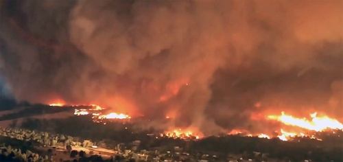
University of Nevada-Reno physics professor Neil Lareau documented this atmospheric phenomenon, a firenado, at the Carr Fire that devasted the region surrounding Redding, California in July.
A new analysis in Geophysical Research Letters posits that this "Pyrotornadogenesis" resulted from a combination of factors. A key factor in the vortex formation was the development of a fire-generated ice-topped cloud (known as a pyro-cumulonimbus) which reached as high as 39,000 ft. The development of the cloud helped stretch the underlying column of air, concentrating the rotation near the surface and causing the tornado strength winds, estimated at 143 mph, the strength of an EF-3 tornado.
Radar data show that the vortex formed along the fire perimeter and within a pre-existing region of wind shear immediately following rapid vertical development of the convective plume, which grew from four to eight miles high in just 15 minutes. The plume development was fueled by the onset of the pyro-cumulonimbus cloud, a process similar to the development of an ordinary thunderstorm. It is this link to the cloud aloft that distinguishes the Carr fire vortex from more frequently observed fire-thirls, which tend to be smaller and less intense.
Other factors contributing included:
An unusual warmth throughout July which led to drier conditions
A five-year drought was followed by a near record wet season and that led to a lot more vegetation
A near-surface cyclonic wind shear zone that developed in the hour prior to vortex formation. The release of moist instability in the fire-generated cloud aloft
Weather factors including very low humidity, record high temperatures, and terrain-channeled winds due to low atmospheric pressure.
Citation: N. P. Lareau N. J. Nauslar J. T. Abatzoglou, The Carr Fire Vortex: A Case of Pyrotornadogenesis? Geophysical Research Letters, 21 November 2018, DOI: 10.1029/2018GL080667


Comments