Banner
By Patrick Lockerby | July 22nd 2010 12:06 PM | 4 comments | Print | E-mail | Track Comments
About Patrick

Retired engineer, 60+ years young.
Computer builder and programmer.
Linguist specialising in language acquisition and computational linguistics...

View Patrick's Profile
Ashfall On Katla


Unless you have been vacationing on the far side of the moon, you will have seen lots of pictures of the recent Eyjafjallajökull eruption.


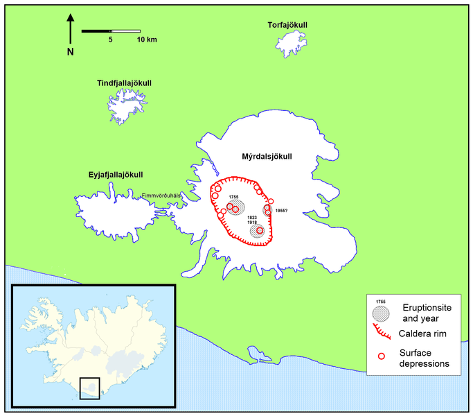
Location map, courtesy Wikimedia Commons

On July 12 there was a break in the clouds over Iceland making it possible to see the area of the volcano.  I have been waiting for a better picture, but according to Murphy's law the cloud will only disperse fully once I have lost patience with waiting and posted the Jul 12 image.

On July 12 2009 Eyjafjallajökull's neighbor Katla's Mýrdalsjökull ice cap was clean and white.


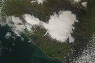
Eyjafjallajökull and Katla's Mýrdalsjökull ice caps - July 12 2009


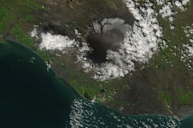
Eyjafjallajökull and Katla's Mýrdalsjökull ice caps - July 21 2010

Edit: wrong date given for above image (12th) - corrected to 21st.
image source:
http://rapidfire.sci.gsfc.nasa.gov/subsets/?subset=Arctic_r01c03.2010202...


I wonder just how thick the ash cover is on Katla.  Is it deep enough to insulate the ice and slow down melting, or thin enough to promote melting through albedo change?

Time will tell.

Comments

I looked at the Terra/Aqua pictures and saw the nice ash deposit. It is just that I seem to be looking at the wrong spot. North West of where Katla is, under the larger icecap. Has anothe Icelandic volcanoe errupted as well?

I think it was Iceland.

logicman
Tony:  Thanks for the question.  I gave the wrong date for the last image and omitted the link - sorry!  Now corrected.

There have been no other eruptions this year.  Here's an image with the names of the main volcanoes.


image source:
http://rapidfire.sci.gsfc.nasa.gov/subsets/?subset=Arctic_r01c03.2010202...

It looks like the small  Tindfjallajökull icecap has melted.


Here's the same area in July  2009:

image source:
http://rapidfire.sci.gsfc.nasa.gov/subsets/?subset=Arctic_r01c03.2009193...

You can see from comparing the images just how ash-covered the ice caps are.

It was Grimsvotn that I was looking at. Add a bit of dust to an existing feature with a lack of knowledge. Thanks for the clarification.

logicman
You are more than welcome, Tony.  It's what I'm here for. 

Without my readers, this would all be just so much futile graffiti.  :-)

Add a comment

The content of this field is kept private and will not be shown publicly.
  • Allowed HTML tags: <sup> <sub> <a> <em> <strong> <center> <cite><TH><ul> <ol> <li> <dl> <dt> <dd> <img> <br> <p> <blockquote> <strike> <object> <param> <embed> <del> <pre> <b> <i> <table> <tbody> <div> <tr> <td> <h1> <h2> <h3> <h4> <h5> <h6> <hr> <iframe><u><span>
  • Lines and paragraphs break automatically.
  • Web page addresses and e-mail addresses turn into links automatically.
CAPTCHA
If you register, you will never be bothered to prove you are human again. And you get a real editor toolbar to use instead of this HTML thing that wards off spam bots.