

There is no such thing as a perfect translation.
En effet, on peut être utile sans atteindre à la perfection;
Agenda, ou tableau général des Observations et des Recherches dont les résultats doivent servir de base à la théorie de la Terre, H. B. de Saussure, 1796.
This article contains my translation of Ignatz Venetz's 1821 prize-winning Essay on the variations of temperature in the Swiss Alps - Memoire sur les variations de la température dans les Alpes de la Suisse.
For further background information, please see Ignaz Venetz - Climate Change Pioneer.
For a plain text transcription of the original memoir, please see Ignaz Venetz - Climate Change Pioneer - #2.
The essay was written in response to a request for papers and the offer of a prize by the Helvetic Society of Natural Sciences. The time allowed for responses was two years, which, for a scientific study of the Alps, amounts to two summers, hence Venetz's remark on the first page about the time allowed being too short.
The terms 'we' and 'us' used by Venetz are by no means all archaisms. He did not carry out this study alone. He was assisted in his endeavours by many scientists, engineers, scholars and mountain guides, many of whom are named in his essay.
I have retained the original place names used by Venetz, even though many have changed, if only in their spelling. I have done this to leave this translation as a historical record of the changed names.
I have tried to retain the style and vocabulary of the written English of Venetz's times so as to retain the 'look and feel' of the original : also to avoid introducing errors which might arise due to modern nuances of English. I have also retained the original pagination.
The original French is the Swiss French of Valais of about 200 years ago. Since I am by no means a speaker of even modern French, it may be that some of my readers who speak fluent French will disagree with my translation, here and there. If you are such a reader, please do leave a comment with your suggestion for an alternative translation.
I have added only a few footnotes of my own and these I have placed in square brackets [thus].
The reference to Virgil will likely be obscure to most 21st century readers, so here is the relevant passage in Latin together with my own translation of it -
From Virgil's Georgics, Book I:
At prius ignotum ferro quam scindimus aequor,
ventos et varium caeli praediscere morem
cura sit ac patrios cultusque habitusque locorum
et quid quaeque ferat regio et quid quaeque recuset.
Before our iron ploughshare cleaves new clay,
The winds and augured skies our task concerns,
And tillage of the land the ancient way,
And what each region grows, and what it spurns.
----------------------------------------------------
This paper is often cited as having been published in 1833. The formal citation is -
I. Venetz, Memoire sur les variations de la température dans les Alpes de la Suisse (Rédigé en 1821), Mem. Soc. Helv. Sci. Nat. 1 (2) (1833) 1-38.
I am certain that the use of the term 'Rédigé' - 'written' has inclined some writers to believe that the paper was not published until 1833. The paper was in fact awarded a prize by the Société Helvétique des Sciences Naturelles in 1821 - and thus, as far as the history of science is concerned, was officially published in 1821.
Accordingly, I feel that the term 'Rédigé' should no longer be used. To cite this translation, please use the following -
I. Venetz, Memoire sur les variations de la température dans les Alpes de la Suisse (1821), Mem. Soc. Helv. Sci. Nat. 1 (2) (1833) 1-38.
Trans. P. Lockerby science20.com(2011)
My translation - in plain text - follows below this page separator >>>
.......................................................................................
Essay on the variations of temperature in the Swiss Alps.
by M. Venetz, Chief engineer of the Valais Canton. Written in 1821.
Translated from the Swiss by Patrick Lockerby, July 2011.
.......................................................................................
1
Essay on the variations of temperature in the Swiss Alps.
by M. Venetz, Chief engineer of the Valais Canton. Written in 1821.
Ventos et varium coeli praediscere morem,
Cura sit ...
Virgil.
___________________
The Helvetic Society of Natural Sciences is concerned, for the second time, with a question all the more difficult to resolve in a satisfactory manner, since many causes come together to put obstacles in the way of whoever would wish to attempt it.
The time allowed appears at first too short, if one considers the nature of researches which, rarely recorded in the archives, cannot be retrieved except with difficulty. Should one not also need time to travel and examine the effects produced by the decrease or increase of the glaciers, as well as to observe the condition of the alpine pastures and that of the growth of the forests ? Now add that it is not a question of making observations at a run, but that it is necessary to maintain a rigorous accuracy, a sustained attention, and that this skill is not given to everyone to have.
We are far from fooling ourselves about our feeble talents, and we are aware that we do not have anything of that which can lead fortunately to the goal: also we do not aspire to win the prize, and if we present this little memoir, it is only to advance the matter by reporting that the facts, in part, contradict the general view of the strong cooling of the Alps.
......................................................................................................
2
Since the last great change that our globe has undergone, the temperature of each place must have followed the course that its position relative to the exposure and the distance from the sun will have produced, unless it has been raised or lowered by other circumstances.
However, it appears to us that one does not know yet either the changes that may have taken place since the said period, or the causes that produced them, nor the particular circumstances that can lead to changes in temperature.
If one had the ability to take the average temperature of all the years which have passed since the time of the said change, and all areas of the surface of the globe, maybe one would find that in general temperature has not undergone changes, but by comparing it to shorter periods and in the same area, one will become convinced on the contrary that it has always varied.
Thermometric observations of our air show sufficiently, that the temperature of one or several years is well above that of others. It even appears that one or more whole centuries had this advantage over others.
What was, in past centuries, the temperature of Switzerland ? Was it more or was it less than that of today ?
Before deciding this question, much extensive research is required, and many comparisons, often remembering what Virgil said in his Georgics, Book I:
Ventos et varium coeli praediscere morem
Cura sit ...
(The winds and augured skies our task concerns, ...)
In the absence of thermometric observations, one must resort to means by which one can roughly gauge the state of the temperature in ancient times.
These resources, however, are few, and at times hardly go back far enough, and if one is not very careful, they can give rise to large errors, as with the deterioration or improvement of pastures. A mountain that once supplied little greenery to cattle, may have changed in nature, with works properly applied and maintained in good condition, without leaving remnants of the works
............................................................................................
3
which have brought about these changes. An ancient document which states that a location did not support before the least part of the livestock that it can maintain now, would certainly prove the improvement of the place, but not a change in temperature.
It is the same with deterioration ; a mountain may have lost much by neglect and by unknown causes, but the consequences without these effects being of necessity attributable to a change in temperature.
The previous and present condition of forests can also lead to very large errors ; since the same deterioration may have occurred at various places without our being able to discover the true causes. Often attributed to the decrease in heat is that which one ought to attribute to the destructive hands of men, who, to exempt themselves from a somewhat longer journey, cut the tops of the woods and carry them into the mountains to make cheese. Through this continuous cutting, the forests thin out more and more ; the passing of the goats, the scourge of forests, preventing the growth of young trees ; they have the form of grass, the seed can not penetrate the earth. Old trees, that man has respected so far, perish isolated from the rigours of excessive cold ; and in this way a gradual deterioration of the forests takes place, which one might attribute to a lowering of the temperature. Observations of this kind should be admitted only after the strictest examination, so we will mention only a few examples of this kind, but they will be accompanied by some other observations.
The facts which show that trees and other plants, that man seeks to preserve, cannot succeed in places where they once prospered ; or else, if one can prove the existence of forests in places where they could not exist in ancient times: these facts seem admissible, to prove the raising or lowering the temperature.
If one discovers much frequented passes in the mountains, which were formerly blocked by glaciers, or paths which, formerly free, are now impracticable: these facts can be admitted, if they were not produced by purely local circumstances.
The ruins of old buildings, debris of roads, etc., can often shed some light on the ancient state of our mountains.
But nothing seems more calculated to make known the temperature of ancient times, than the increase or decrease of the glaciers, as it is
............................................................................................
4
the necessary consequence of the raising or lowering the line of eternal snow. Some naturalists *) have believed that these changes in glaciers, could not arise from the temperature, since one sees some glaciers increase while others decrease, they say the ice gains on one side what it loses another. This idea does not seem to us admissible, and the phenomenon of glaciers ought to be explained without resorting to assumptions to which one cannot assign causes.
It is known that the line of perpetual snow was greatly elevated in 1811.
The glaciers had decreased significantly for some time, when the cold years of 1815, 1816 and 1817 recharged the mountains with a very considerable mass of snow, which lowered that line several hundred feet. At that time the glaciers that found themselves on steep slopes, charged with so great a new mass surged in an astonishing manner into the lower regions. We have seen the Distel glacier in the Saas valley, near the Monte-Moro, descend more than fifty feet in a year.
In the Valley of Hérens, a glacier, it is said, advanced with a noise like thunder, increasing at that time no more than ten feet in length. The glaciers that have but little slope, able to support this new charge, gained much in thickness, they say that they advanced but very little over the years.
It is natural that the glaciers, that descend with great speed in a warm climate, discharge their surfeit of ice more rapidly than those which advance slowly. It is also natural that the latter should advance further, even if their comes a time of many warm years, which are already causing the others to retreat, because their mass does not decrease so quickly. As all glaciers repose on differently inclined bases, it is certain that they have different rates of advance and retreat.
This observation seems to us sufficient to prove that, despite appearances to the contrary, the increase or decrease of the glaciers stems from the temperature difference.
*) De Saussure, Voyages par les Alpes §. 54l. Kasthofer, in his prize-winning essay in 1820.
[Presumably Karl Kasthofer, who was appointed District Forester in Interlaken in 1806.]
............................................................................................
5
The origin of glaciers with all their properties has been sufficiently described by
Messrs de Saussure, Gruner, Ebel and others. We shall not enter in detail, nor into the difficulties which have arisen afterwards, in relation to their growth. For proving by means of moraines *) to what extent glaciers descended before, it does not matter if they advance through the heat of the earth only, or also by the expansive force of freezing water, since in each assumption, the snow and inclement weather are the main causes.
Here are the clarifications that we thought necessary to support our observations. We now begin to cite the
FACTS
which tend to prove a lowering of temperature.
I. The Dent de Forclaz glacier, in the valley of Cheville, Valais Ardon commune, often covers a kind of stone bridge which one can see only rarely. Here's how one member of the Grand Council of the Vaud canton **) communicated to us the observation he made at the scene:
"The construct, about which you would like information, is at the side of the mountain known as the Chamosenze and located so as to have, to the west, the dent de Forclaz glacier, often fully covering this work, even in summer and whose water flows under an arch to the east and crosses the Dorbon mountain to reach Liserne ; to the north Paschieu tower, to the northwest grand Meuvran, to the southeast of the dent de Forclaz , to the south the little Dent de Erchen. The bases of these rocks encircle a very narrow valley, which opens only on the Dorbon side. The names that I indicate are those given by the mountaineers of Bex, who also give the name 'Bridge' to the construction that is in this place: it is seventy feet long,
*) During their advance, glaciers have the property of pushing before them the land, stones and all foreign bodies ; for this reason these materials almost always surround the foot of these huge masses of ice, forming a slope of about forty-five degrees. When the glaciers retreat, these kinds of ramparts or spaces, called moraines, are left behind, forming the same slope in the interior, or against the glacier.
**) M. Favre, director of Bex salt mine.
............................................................................................
6
seventeen high in the middle, and nine wide. I saw only one fairly narrow arch which was partially obstructed by snow. all is constructed of rough stones, which are not very carefully chosen, and do not appear to have had mortar applied. The bridge runs from the side of the mountain of Chamosenze over the bed of the glacier stream, to a rounded hill which, when I saw it, was stripped of vegetation, but which one can presume had formerly been a pasture where they brought the cows from Chamosenze , using the bridge which would have been built for this purpose. I neglected to note the date when I made this journey, it is about twenty years. I was told then that the peasants of Chamoson and of Ardon gave this construction the name of Barre and that they believe it was started and left unfinished by monks in white garments, in order, if they had been able to finish it, to divert the glacier stream on the mountain of Chamosenze so as to lead to properties they had, it is said, at the foot of this mountain. We may perhaps receive some information on this subject from some old men of these villages, and discover if there are in these municipalities any documents which report the construction, or the monks. "
The monks dressed in white, who had properties in Chamoson municipality, drew their water through a conduit from the Liserne, whose traces can still be seen, however, we doubt that the source of this water had been made so high, but whatever the purpose of this work, it is certain that one does not undertake an enterprise, if one can assume that a glacier must destroy it.
II. The col de Fenêtre in the valley of Bagnes, appears to have been formerly in frequent use. There are still remnants of two buildings and human bones. It is believed that it was a cut in finances which Valais had made which served to close this passage, as is seen again in Trento, in the Tete-Noire and elsewhere *).
The canon de Rivaz, found among the writings of the municipality of Bagnes, many deeds that stated that this municipality had the right of free trade with Piedmont, via Charmontanaz
*) In 1822 we traversed this pass, the two buildings appeared to be nothing but ancient remains, it was then for trade, not nowadays, that they were built.
............................................................................................
7
and the col de Fenêtre, despite protests that the owners of the right of
discount (of Souste), established on the route of the Great St. Bernard, made against this right. That learned antiquary has also provided a copy of a document which establishes the likelihood of the passage of an army of Savoyards *) by the col de Fenêtre in the month of April 1476 **).
It is now very rare to see mules traverse this pass, the path has become very difficult. It seems that in those days, one had no need to cross the Montdurant glacier, as at present.
III. In the said archives, the same M. de Rivaz has also found a document that
speaks of a trial that the municipality of Bagnes had with that of Liddes relating to a forest, located on the territory of Bagnes, of which Liddes claimed ownership.
The forest no longer exists ; a huge glacier replaced it and communication between Liddes and Bagnes was completely destroyed in that place.
IV. From Praborgne (Zermatt), Viège valley (St.-Nicolas valley) there was once a very popular path to the valley of Hérens.
*) M. de Rivai believed that it was, rather, the Lombards.
**) Here is part of the document, the original is in the archives of Bagnes:
"In nomme Sanctae et individuae Trinitatis, Patris et Filii et Spiritûs Sancti. Amen."
"Anno a Nativitate Domini nostri Iesu Christi 1476 Indicatione nova , die autèm 19 mensis aprilis , in Valle de Bagnies ante Grangium Antonii de Accre per hoc praesens publicum Instrumentum cuntis pateat evidenter et sit manifestum. Quod cum nuper eo tempore quo pro Restauratione terrae ab antiqua pertinensis Ecclesiae Sedunensi Exercitus armatorum Vallesii descenderat per Chablesium et apprehenderunt quotque plura castra et villas usque ad Martigniacum inclusive. Accidit quod homines Vallium de Bagnies et Intermontium se reddiderunt Reverendissimo Domino nostro Sedunensi Episcopo et Patriotis terrae Vallesii et itaque sub jurisdictione et ptotectione eorundem permanserunt usque ad istos dies proxime elapsos, infra quod modicum tempus nonnulli ex praedictarum Vallium hominibus actu proditorio procubabant quod multitudo armatae Sabaudorum ex Valle Augusta intrabant et apprehenderunt praenominatas Valles Intermontium et de Bagnies et quosdam exstipendiariis Vallesiensibus interfecerunt adjutorio multorum ex praedictis Vallibus incolarum. Et quia pro agenda vindicta illius actûs nequiter perpetrati et pro restautatione Vallium Patriotae Vallesii modo cum potentia intrabant ipsas Valles et Sabaudorum armatos expulserunt, et quaedam ex Villagiis Intermontii ignis incendio consumarunt , et denique ambas easdem Valles Spolio castigabant. Sic interventu proborum et discretorum hominum, qui missi fuerunt super Vallem de Bagnies partes infra scriptae scilicet, etc."
(There follows a great number of names. Bagnes was required to pay to the seven districts of Valais an annual sum of 70 maurisois pounds.)
[ livres maurisoises - currency of the French municipality of Cour-Saint-Maurice]
............................................................................................
8
At Evolène, the last village in the Hérens district, there are still families from Praborgne (Zermatt) and vice versa. In 1816, April 20, that municipality acquired from the chapter of Sion a fee from an annual procession that this community made to Sion, to the valleys of Tzmut and Hérens. The mountain that separates the two valleys, is currently covered with glaciers, which makes this passage so dangerous that the boldest hunters have difficulty in penetrating from one valley to another, we know of none other than Joseph Perren, these days, who has passed through this mountain.
The municipality of Evolèna must also have titles by which it proves that it possessed the right of free trade with Piedmont. The pass between these lands and the valley of Hérens is even more difficult than the col de Fenêtre.
V. From the Loetschen valley in Valais, one cannot go except on foot to that of Gastern, Berne canton, while the passage was formerly open to horses. M. Captain Gattlen of Rarognr, has seen walls that still exist that supported the old pass, known as the Trattern. The said Gattlen found at Gampel, a document that clearly indicates that the government was interested in maintaining this exit.
VI. From Fiesch (Viesch) Conches valley in Valais, there was once a popular pass which went through the valley of Fiesch (Viescherthal) to Grindelwald. In this town they still show a bell bearing the date 1044 *), which, according to reports from inhabitants, was suspended in the chapel of St. Petronilla, located on that pass. From the Valais side, there are still traces of the road which went to Grindelwald.
This egress is now so clogged with ice, that it has become impassable. At the time when Valais belonged to France, smugglers tried several times to penetrate it, even with ropes but without success.
VII. In the valley of Grub (Grubthäli), which dominates the mayens of Gruben **) and Meiden, of Tourtemagne valley, there are still found, according to the testimony of the notaries of Inalbon, who saw with many
*) Ebels Travel Guide for Switzerland. S. Grindelwald. Third edition.
**) In German: Mayensitz. Grand Chalet, where shepherds remain during the
summer with their families.
............................................................................................
9
others, a great stretch of paved road leading through the valley, called Augstkumme, in the valley of St. Nicolas. It is claimed that Meiden and Gruben were villages ; one can still find slag from forges. The pass through the Augstkumme is abandoned by chamois hunters. We do not know with what a paved path in that place may be related. Was the plain impractical at the entrance to the Viège valley ? Or, were there so many villages at that height, that this road was made necessary?
VIII. It is also known on each side of the Monte-Moro the horse road that, before, from the Anzasca Valley (Vallis Antuatium) was going to join that of Saas in Valais. There are still paved paths of half a league in length.
A second road wends likewise from the valley of Saas to Antrona.
According to a manuscript, a kind of chronicle of the Saas Valley *), these paths were already very old in 1440 **). It says that in 1515 there had arisen a dispute between the inhabitants of Saas and those of Antrona. The judge was from Lucerne, but as in those days the Swiss had occupied the borders of neighboring Italy, where Cardinal Schinner had appeared as a soldier, the order to the people of Antrona to mainten the road has had no effect.
In the first half of the seventeenth century, the temperature was much lowered and the passages have become very difficult. At that time the lake formed by glacier Distel, broke out for the first time. Also in the eighteenth century: especially in 1719, 1724, 1790, people went
*) Die Geschichte des Thales Saas (The history of the Saas valley) ; a compilation of a number of published documents. By Peter Joseph Zurbrüggen, beneficiate to St. Antoni of Padua.
**) Here is what the manuscript says in this regard:
"1440 wurde von den Saasern und denen von Antrona die uralte Strafse uber den Berg hergestellt ; beyde mufsten ihren Theil erhalten bis auf den Gipfel des Berges."
In 1440 the very ancient road to the mountain was repaired by the inhabitants of Saas and Antrona, each party was obliged to maintain its share to the top of the mountain.
In another place, a chapter about remarkable objects, he said:
"Auf Antrona und Makunaga passirte man vor Zeiten haufig mit Pferden , mit allerhand Vieh und vielen Kaufmannswaaren , und wurden schon im Jahr 1440 uralte Passe genannt."
In former times people passed frequently on horseback, with all kinds of livestock and many goods to Antrona and Macugnaga. and already in 1440 it looked as if this path was very ancient.
............................................................................................
10
to great trouble; they were even put to considerable expense to repair the Antrona road, in order to be able to transport salt and other commodities ; but each time the repairs lasted only a short while.
We are acquainted, however, with several individuals from Saas who have known people of the valley who, on the backs of mules, carried wine from Macugnaga to Saas. It is true that, in these recent times, people were already crossing a glacier, which has increased so much since then that this path cannot be used by horses.
One can still see the places where people used to stop to feed their beasts of burden.
It is clear that this path would not have been created at great expense, if in that time, a glacier had existed on it, for one would have expected that at some moment or another it would have rendered impassable.
IX. A new glacier has formed since 1811, in a place called Budumynen, situated under the Galenhorn, Saas Valley. Until then people had never heard of the existence of a glacier in this place. It was Venetz Joseph, owner of the place, who communicated this observation to us.
X. Rothelsch Glacier, which dominates the new Hospice of the Simplon, is not old. Mr. Escher, curé of Biel and a native of Simplon, told us, he found some manuscripts at the Hospice which prove that the glacier did not exist in 1732. Joseph-Antoine Escher, innkeeper of Brig, who during his youth had remained in the old hospice of Simplon, and several other individuals of this country, still remember very well, that in their youth there was only a small amount of snow.
Also M. de Saussure *) considers the glaciers to be a recent formation.
XI. When the new Simplon road was opened, tree roots were unearthed on the summit of this passage. A place near the highest point is called Au Mélèse (im Lerch), where there are trees no more. The destruction of woods, in the latter, seems to us the work of man, since at the bottom of the said place, there are still many trunks of larch, but the roots found on the height of Simplon must indicate a cooling; since one can no longer find trees
*) Voyages par les Alpes, §. 541. (Travels in the Alps, §. 541.)
............................................................................................
11
at that height, even in inaccessible areas, except where they are not exposed to cold winds, as with the height of Simplon.
XII. Towards the glacier which overlooks the Bourg St.-Pierre, Valle d'Entremont, we have seen, at a great distance above the highest forest, a tree of extraordinary size. The Chief Judge of Lasoix de Sembrancher has seen it, and the late Prior Murith, and others. It is very likely that it may still be found there *).
XIII. Clement Roten of Savièse, an old man still living, found in his youth on the height of the Sanetsch mountain a very large tree trunk, which served some time for the making of the cheese of that mountain.
We have never heard that trees existed on the height of Sanetsch, which is about a league from the crossing. On each side of the mountain, even in places most sheltered from cold winds, and in inaccessible areas, the growth of trees does not currently exceed the height of this passage **).
*) "In 1811 Jean Etienne Moren, President of the municipality of Bagnes, found in Boussin a gunshot from Breuncy glacier, a trunk two feet in circumference in a pile. Nowadays the last trees languish two leagues from the said place."
"In 1826 in Loui, a mountain overlooking the forest region, the same Mr. Moren has unearthed an entire tree, while draining a swamp. It was a stone pine (Pinus cembra) in which the white had disappeared, but the red was found as healthy as when it was alive."
"It is believed that this witness of a high temperature formed part of a forest that once existed above the rocks which are at the base of Lombard. The President has directed that it be buried again to serve as a dam, where it will be conserved for future times. It will not be difficult to see, being in a known place and it will be easy to remove the earth that covers it. "
**) M. Gruner cites similar observations. Here is what one finds in the tradition of Frances M. Keralio, pag. 329 and 330:
"The inhabitants of the Hasli valley, in the Bern canton, complain that the mass of ice, growing little by little, took over entire valleys, and covered fertile land. Ancient charters show indeed that Fleur-de-Lis valley, on the Gaul, extended once from Gletscherthal up to Grindelwald. The Grindelvaldois complain that one of their valleys, now filled with ice, was once accessible and was passed through to go to the baths of Fischer (Fiesch) in Vallis (Valais). Those of Lauterbrounnen assert that the sides of their mountains were once covered with fine pastures; that Ammerten was a large town, and the Val Rouge (Rothethal) afforded a passage to get to
............................................................................................
12
XIV. Near the parish church of Taerbel, Viège valley, the property named : Zur Stapfen, owed annually to the main church of Visp a certain amount of walnut oil, proving that walnuts were once found on that high property, where now only a cherry tree languishes.
XV. In Fribusi between the two bridges at the entrance to the Anniviers valley, Sieur Joseph Salamin, an elderly person of Luc, saw vines living, more than fifty years ago. The same person saw in the latter place, a large cherry fruit bearing good fruit and below this village a young walnut tree. Now we find no fruit trees at that height (in Luc), nor any vestige of vine in Fribusi.
XVI. Above the village of Pont-Neuf, Viège valley, in a place called Gub, we found vines alive. Sieur Joseph Venetz, miller of Pont-Neuf, successfully transplanted several. They are the species known as Heidenwein (wine of the pagans), which is unique to the mountain of Visperterminen.
There are retaining walls and ditches from viticulture, unused in this country for this type of cultivation.
There is no means of telling when the vineyards were worked, this place is considerably higher than all the current vineyards of the valley, and probably all of Switzerland.
Near Pont-Neuf, there are vineyards and abandoned fields in several locations.
" the Froutiguen valley and the Vallis ; but these days all these places are buried under the ice. The inhabitants of Siebenthal say, that the glaciers of the mountains Ghelten and Raetzli gradually took over fertile lands. The Faucigny, the Vallis, the Uri canton, and Glarus echo such complaints, and most are confirmed by authentic charters. I will examine the mass of ice at Grindenwald in this regard ; all the others can be judged by this. " " According to oral tradition, this mass has existed from time immemorial, but the valleys which it fills today once had many pastures : there was also certain evidence that it has taken over fertile land. On the flank of Ficherhorn (Viescherhorn) and the Eiger, in the middle of the ice, one sees several trunks of larch, which have been there perhaps for centuries. It is known that this wood has the ability to harden from the moisture; those who ascended to these trunks, say that one cannot detach the smallest part with the sharpest knife. "
............................................................................................
13
On Mount Visperterminen above the highest forests, there is a place called: im Heiden. The popular tradition is that this locale was formerly a vineyard, from which proceeded from the Heidenwein mentioned in this article *).
XVII. Several books about Valais cite Brigue and Moerel on the vinyards **). There are even those who say they produced excellent wine. However, there are now only a few isolated or rather wild vines, and some vines in front of houses, but the grapes ripen there only with difficulty.
We believe that this error originates with Simler, who claimed that the vines begin at Moerel. The vineyards of these lands, were they renowned in his time, or at least before him? One might think, after what we have said, and from the name Weingarten (vine garden) that were given to a place near Naters, and another near Gliss, confirm, albeit weakly, this assumption.
XVIII. Captain Willisch of Stalden, who died this year (1821) at the age of 88 years, found in his youth in the place called Galen, near Mattwald, Saas Valley, a vine stock living at such an elevation that he did not think cherry trees would grow there. There are today many people who have reported this fact.
XIX. In the village of Fang, Anniviers Valley, one finds a few vines in front of the houses, but for about 30 years it is no longer remembered that the grapes ever ripened.
XX. There existed formerly a small village in the mountains of Pauchet, same valley. One can still see the foundations of several buildings, and boundaries dividing the fields into very small plots. People now living have seen a cherry tree. Now there is nothing growing but a little grass, fir and larch.
This fact does not prove, however, as much cooling, as at first appears.
By travelling through this place, we found a fairly large road, which indicates that, before the opening of the one which crosses
*) The stock of this vine differs entirely from all the qualities known to us.
**) Statistischer Versuch uber den Canton Wallis. Pag. 103. Ebels Anleitung die Schweiz zu bereisen. Art. Brigue.
(Statistical experiment about the Canton Valais. Page. 103. Ebels Swiss travel guide. Article Brieg.)
............................................................................................
14
the two frightful ravines of Pontis, where the road is carved into almost perpendicular rock, one entered through Pauchet into the valley of Anniviers. We also found many traces of two aqueducts that served to bring the water from the Sandolin mountain in Pauchette. This road and water pipes were destroyed by the ravine of Illgraben, which still extends more and more towards Anniviers, pushing the debris of the mountain to the Rhone, near Louèche.
XXI. In climbing to Riddes on the Etablon Pass, near the tip of Pierre-à-Voir, one finds at the top of this mountain the ferruginous rhododendron (Rhododendron ferrugineum) which perished at a height of about 200 feet. We similarly observed that the grass and the trailing azalea (Azalea procumbens) are dead in all the high mountains, such as Pierre-à-Vire, on the Mauvoisin in Bagnes ; on the Alps of Albinen, near the baths Louèche, in the summits of Tion, near Zion and elsewhere. This destruction is, however, recent and comes from the cold years 1815, 1816 and 1817.
XXII. Destruction, of which we have spoken, has singularly affected the pastures of the Alps ; the one mountain - Charmontana - in the Bagnes valley that fed one hundred and twenty cows, lost a day's food to each chalet that there is in Tzanrion, at the large and small Charmontana: chalets where cows remain periodically during the summer.
______________________________
It appears however that the progress of this cooling trends, from that time, nears its end ; the line of perpetual snow has risen significantly since 1818, and the glaciers follow, which commence their retreat, heralding the same thing.
A. In August 1820, we observed that the lower glacier of the Allée-Blanche had not advanced much, and that the glacier of Brenva had given back 50 feet of land after reaching the ruins of a chapel, that M. de Saussure cites in his Travels through the Alps §. 855.
B. In the same journey, we similarly observed that the Fribouge glacier in the valley of Entrèves, above Courmajeur, had also retreated several feet, as well as that of the Triolet by the col de Ferret.
............................................................................................
15
C. At the same time we examined the Breuney glacier in the Bagnes valley. In some places it again touched the Moraine, which it had pushed ahead before, in those parts which were most exposed to the sun, it was found to be a few feet back ; it had decreased considerably in width. The glacier of Hautemma, above Tzanrion, in the same valley, was twelve feet behind the new wall.
D. In the month of October 1820, we saw that the Chalen, or Tzalen, glacier, descending from the Dent du Midi near St.-Maurice opposite the Val-d'Illier, had greatly diminished. This glacier is located on a very steep hill, and proves what we said at the beginning of this memoir, namely, that some are already retreating, while others advance again.
E. In August 1821, we observed that the right end of the Prafloray glacier in the Hérémence Valley, was some ten feet behind the new Moraine, while on the left, it still touched it. This difference comes from its position relative to the sun, and at the same time shows that the glacier is not advancing.
F. In the month of September following, the Durant-en-Tzina glacier in the valley of Anniviers, had retreated by six feet from the last rampart it had formed at its base. Finally, judging by what the mountaineers say, all the glaciers have lost thickness, during the past three years. All those who we have had occasion to see several times since 1818, we have confirmed this observation.
It is very remarkable that, despite their reduction in thickness, many glaciers, even most, still advance significantly *). This circumstance serves to support what we said on page 4, that the great glaciers of little slope gain much in thickness as a result of some poor years, and after an amelioration of temperature, they follow once more their progressive march while the others are already struggling in retreat.
____________________________
Here are twenty-two facts which tend to show a cooling. It would have been easy to include more. If we had had time to do the necessary
*) That of Aletsch, the largest and perhaps the thinnest in all of Switzerland, was even in 1828, in this state.
............................................................................................
16
research, and if we wanted to believe the popular traditions, we would quote an infinite number of such cases. Thus we say that the Visperterminen municipality payed tithes to the cure de Viège, regarding a place now occupied by the glacier for some years ; that Moerel paid to the cure of Ernen a tax for vines situated above the Blauen-Egguen, in a barren place ; that in Allelin, Saas Valley, vineyards were cultivated in a place which the Distel glacier now touches, etc.
Most of the facts we have cited are reported on the basis of the integrity of individuals, of whom we have named several. These facts, however, gain more confidence where they agree so as to substantiate the same cause, despite their variety and the remoteness of the places where they were observed.
Now let us now see if we cannot find some
FACTS
tending to prove an elevation of temperature.
These facts will be quite solid ; we have seen most of those that we shall allege. Some distinguished naturalists have seen a part of them with us, and we only talk about a few, that have been noticed by other famous naturalists. We have not, however, cited former moraines, because we have not discovered other documents in this regard.
Many travelers who visit the high Alps, take a tour of Mont Blanc, through the passes of Bonhomme, the Seigne and Ferret. We think therefore that we should commence with the glaciers, which are the most accessible to observers.
1. In the Montjoie valley *) Savoy, beyond the stone bridge that one passes after leaving the village of Contamines to ascend Bonhomme, one sees on the left a mound covered with a thick pine forest, in which a small ravine, caused by the scouring of the currents of the Bonhomme, suggests that the soil of this mound is composed of debris. Climbing higher, we find the chalets of Gieta, built between three quite distinct ancient moraines, that the Trelatete glacier had pushed thus far, and the said mound belongs here. The glacier is now
*) Bonhomme valley, Bourrit.
............................................................................................
17
about 7000 feet from the said chalets. It appears to have caused a very recent moraine.
2. About half a league higher, under the red rocks, located between the tip of the Pinna and the chalets of Prés, the same valley, we see a few hundred feet from each other, two almost parallel prolonged elevations just at the bottom of the valley, and formed in between them a kind of cradle. These elevations end ridges, of which both sides incline at about forty five degrees, showing that they are moraines. On one of these ridges is a great boulder deposited there, without doubt by a glacier which at the same time had formed them.
This glacier whose site was exposed to the south, has disappeared and we doubt that there is any record of its existence *).
We believe it occupied the entire site where the chalets of Berme are now found. It appears however that a long time has passed since the glacier has left this place, since weathering has left deep excavations in a large stone next to a chalet in the mountain.
3. The glaciers of the Allée-Blanche have large moraines, one of which crosses the valley and is cut through the middle, to give passage to the torrent from the col de la Seigne ; this moraine is still a great distance from the first glacier which, until this day, has not descended onto the plain. The moraine of the glacier is quite small, not far from the ice today. It is beyond doubt that the two glaciers touched before.
4. On the left end of Lake Combal, also known as Lake Allée-Blanche, and on the right of the Miage glacier, there are at least three moraines, which probably formed this lake. To adjust its flow, a lock with gates was made, on which there is a small bridge, by which we arrive on the moraine of this glacier, which one follows for a distance of a league, constantly to exposed the danger of being crushed by stones, which roll constantly from the top of the moraine which overlooks the path from a height of 100 to 150 feet **).
The rolling stones have almost destroyed the trees that had grown on this old moraine.
*) We will mention two more glaciers which no longer exist. See numbers 10 and 33 below.
**) See de Saussure Voyages par les Alpes §. 855.
............................................................................................
18
The danger one courts in passing through this place, might make one believe that the glacier is as advanced as it was formerly, and that the old moraines on its right have remained behind, due simply to the resistance that they offered to this glacier. The following observation might, however, remove these doubts, and make us see that this is nothing special.
In passing through this place, we see that the torrent increases strongly in the bottom of this valley, and when one reflects that this cause has acted for centuries, one can believe that it has destroyed much of the glacier moraines that had formed once and they could, in principle, match those of the lake.
Other moraines covered with tall trees, which one finds on the left of the glacier, about 300 feet of ice, prove again that it was greater than today, and that the route along the path was really decreased by the excavations of the stream. An outburst from Lake Combal which, at that time, must have been very great, might also have burst out suddenly, and if, in the lower parts of the valley, one discovers the remains of a great flood, we could show the cause without knowing the effects, the route between Courrnajeur and Aosta is entirely unknown to us.
5. The large moraine located on the right side of the Prenva glacier, same valley, was not entirely surmounted by its ice in 1820 ; since about one third of the forest, which was formed on the moraine, has not yet been crushed by the rocks that the glacier carries with it.
At length, this glacier had reached the last recognisable moraine ; it began to retreat after toppling the remains of a chapel and some trees of a great size, whose age we have counted from the rings of two trunks giving to one 200 and the other more than 220 years, proof that for more than two centuries the ice has not had the same extent as today.
Here a circumstance somewhat difficult to resolve presents itself,
Mount Chétif, against which the Prenva glacier begins to lean after passing through the valley of the Alley-Blanche is limestone. There are, however, on the glacier face blocks of granite to a considerable height. How were these granites deposited in this place, if not by the glacier itself?
............................................................................................
19
On examining several of the moraines that we have cited, and some of the ones we will mention again, we believe that this glacier is easily able to deposit these granites, but it was necessary that it reached an enormous volume to raise itself to this height, and it is odd that the glacier has not left other traces of moraine on the right, than that which exists, yet we have not discovered them. The lake formed by Miage glacier, would it have been so great in those days, that when the glaciers retreated, a sudden outburst of the lake would have destroyed the ancient moraines of Prenva glacier ? We will not claim that at all *). The areas surrounding the glacier, however, merit better examination.
6. Judging from the piles of rocks scattered around Friboug Glacier, Ferret Valley Courmajeur side, and from a few small moraines that can still be seen on the mountain opposite, the said glacier was once 800 to 900 feet further than at present.
7. In August 1820 we measured the distance from the Ameron glacier **) to the last moraine that can be seen very distinctly in the Ferret valley, near Courmajeur, we found it to be 6300 feet. A second moraine is located 1200 feet from the glacier, it is still covered with some larch, two trunks have indicated the age of 46 to 57 years. The glacier advanced again, after we had been there, and left only a distance of about eighty feet between it and the Triolet glacier that commenced on the contrary to withdraw.
Here one can see, we observe, that, unless there are special events, the glaciers increase on one side, in proportion to what they lose on the other, citing the Triolet glacier which seems, at first sight, to have attained the greatest extent it ever had.
A naturalist has observed that the Ameron and Triolet glaciers, emerging from the same mountain, might emerge from a common basin ; and that
*) The Lac de Distel in the Saas valley, is formed by a glacier ; has broken its barrier many times and flooded the plain, every time that the ice began to diminish, after reaching a very large volume.
**) Glacier de Triolet, Saussure, §. 860. The guide who accompanied us in this journey, told us that name, he gave that of Triolet to the glacier that M. de Saussure called Montdolon : the latter must be found on the Valais.
............................................................................................
20
the collapse of a rock, that protected in 1721, the 14th of September , a pasture below that of Triolet, had lost its equilibrium, emptying more ice on it than ever before ; hence less in that of Ameron, which gave a sufficient reason for the decline of the latter.
There is at first no communication between these two glaciers in their upper part. Mont-Ru separates them by walls that are insurmountable and so high that they could never have touched. How do we explain moreover the existence of two ancient moraines of which one is at 1200 and another 6300 feet from the glacier Ameron? It would be necessary to admit two collapses of the aforementioned rock. Finally all the glaciers that left large moraines now at a great distance from the ice, will they have diminished by similar causes? This we find difficult to believe.
It is easy to explain why the Triolet glacier does not have moraines at distances similar to the Ameron glacier, since, before the collapse of 1721, the glacier was retained by the rock in a sort of basin ; but after that collapse, it must have descended into the valley it occupies today.
We went from the height of the col de Grappillon, which is close to that of Ferret, onto a rock, to get close to the Triolet glacier above the strait, which the rock seems to have missed. We saw on its right about a thousand feet of ice present, and a large amount of debris, that looks a little like moraines. In the gap, the rock is exposed, and appears to have been cleaned. These circumstances suggest that the Triolet glacier was, in its upper part, wider than it is today.
We believe that even in the times before the collapse of the rock it had already been able to overflow and sometimes extend into the valley at its lower end ; because now we have found two small mounds and a new moraine, a short distance from one to the other. These moraines are small, because the soil on which the glacier rests, does not allow it to carry many stones with it, the rock is very solid.
These facts also prove that this glacier advanced at the same time as
............................................................................................
21
the other, and that it is only by accident, that it approached closer than the former, to the debris that it had pushed in front of it before *).
8. Salénaz Glacier, in Ferret Valley, on the Valais, has left to its right a huge moraine, whose end is, measured by eye, approximately 8000 feet from that of the glacier today. From a distance one can easily see that the top of the moraine, which is in excess of one hundred feet high, is divided into two: evidence that it was deposited twice. In considering this moraine and its surroundings, we have no doubt at all that this glacier has never before occupied the village of Plans-des-Fours. The land that this glacier has abandoned is now covered with buildings, beautiful meadows and forests, a great density of which also covers the moraine. It seemed to us that we could still make out to what height this moraine was pushed on the opposite hill. This glacier has necessarily formed a lake, at that time, which, by flooding out, would have caused the terrible floods of which we see the remains all along the valley.
9. The naturalist who visits lac de Champée ought to take himself to the Grand Plan, which dominates the Midi, which invites a view, if not unique, at least very rare amongst its kind. It is impossible to resist the magic of the feeling inspired by the sight of a spectacle so extraordinary. In vain we should attempt to paint what one experiences on a stage so picturesque and majestic which presents a large number of peaks clustered around the aerial giants of the Alps, which sometimes carry their bold fronts into the sombre clouds, sometimes uncovering a head crowned with a thousand rays, whose light, enhanced by the reflection of ice, transports the soul by performing the sweetest charms. If the effect of this sight is so amazing even to an inhabitant of the Alps, accustomed to seeing nature in all its majesty, what may not be the rapture of the city dweller or one who, living far from the mountains, has never seen the like ?
Here the eye plunges to the depths of the Rhone Valley from Verneya to Lake Geneva ; the greenish water of the latter, its enchanted borders, which host here and there elegant cities and beautiful villages,
*) De Saussure, Voyages par les Alpes §. 863, proves that the glacier, even in its lower part, must have been so thick, that it dominated the top of a mound that one finds at least 200 feet above its present surface.
............................................................................................
22
the rich vineyards of the Canton of Vaud rise in an amphitheater, and finally a part of Jura, which provides the setting for this beautiful tableau, offering the most varied aspect.
In walking to his right his gaze will be distracted, he will see first Tours d'Aï which overlooks Aigle and the dent de Morcle on St.-Maurice ; opposite, the crags of Mont Catogne hiding the mountains of Diableret and its regions up to Béca d'Eudon, then Pierre-à-Voie which separates Bagnes from the Rhone valley, the mountains of Pipinetta which crown Sierre, the Alt-Els behind the bains de Louèche, the peaks of the Bagnes with Mont Pleureur, the Combin, the Velan, the peaks of the St. Bernard, col de Ferret outlined against a snowy Piedmont.
One then discovers the tops of Orni and the Arpetta that dominate the Grandplan and finally Mont Revoir, above Martigny, and the chain of the Dents du Midi.
At its feet lies Lake Champée; Orsières with its surroundings, the land of Liddes presents to the same gaze some hamlets and lush meadows.
The appearance of the glaciers afforded us a special interest, since opposite, we see that the moraines of those of the Chaux de Sarayer to the east of Verbier in the valley of Bagnes, and that which rises above Aleve , parish of Liddes, extended to a distance below the lower extremity of the ice today. It is easy to see that these walls must have been enormous, since they are recognised at such a great distance.
10. From Lake Champée in Grandplan the travel is hard. Two paths lead from there, one path to the east, the other to the west of the lake. For climbing, we must give preference to the latter. We chose the one that leads to Pierrier de la Braya, formerly occupied by a glacier that has disappeared. For a while one follows along the foot of the moraine, following a kind of corridor. If one climbs the rolling stones that are on the right, one comes to the wall that is distinctly divided into two. One finds some trees of great antiquity. The moraines formed the right flank of the glacier, which left no trace in the folklore of our contemporaries.
11. Travellers passing through the Bagnes valley and the
............................................................................................
23
Giétroz glacier, grown so famous due to the unfortunate flooding of June 16, 1818, should press on up to Tzanrion, where they will enjoy a superb view of the immense glaciers of the valley *). To reach that place, one passes by the mountain of Chermontanaz, and after passing the Breuney glacier, one encounters a moraine which, in August 1820, was about 360 feet from the end of the Montdurant glacier ; on climbing about 200 feet further, one meets a second which is also very easy to recognise. We see these walls on either side of the Drance, but on the left side of the river, we see that each is subdivided into three: the Montduraut glacier must have formed each of these moraines at three different pulsations.
12. After Tzanrion one can clearly see a moraine, which is at a considerable distance from the glacier of the col de Fenêtre. 13. The lower end of Lirerodzo Glacier (the red glacier) which, at its height, separates the mountain of Giétroz from that of Vingt-Huit, was in June 1820 about 600 feet above a moraine, which it had deposited before in a place a little less steep than the rest of this mountain.
14. At the same time we have seen to the right of Breuney glacier an ancient moraine which is within about 6 feet of the new one. At the end of the glacier, the new wall is touching the old one, and it is only after a small pond that one can with difficulty distinguish the second one.
15. The glacier du Crêt above Bonachissa, same valley, has left many older moraines. A little above the chalets of Crêt, they are almost imperceptible and not clearly prominent except on the right. In ascending a quarter-league above, we find a moraine deposited at the end of an ancient glacier, which surrounds the lower part of a round plain almost 300 feet in diameter (measured by pacing). A rock, which is about 600 feet higher than the end of this enclosure, had parted this glacier. The right branch at that time covered the plain mentioned above. The left, which descended almost as low, had formed some moraines not far from the others, but they are more irregular, and impound a small pond.
*) This view looks very different when one climbs to the summit of the col de Fenêtre.
............................................................................................
24
On the said rock, we also see some moraines, and now the glacier is retreating about 1300 feet away.
Mr Perraudin, counsellor of the municipality of Bagnes, skillful hunter of chamois and lover of these sorts of observations, has assured us that the glaciers of Sévereu of Loui and the Chaux-de-Saraya, all in the valley of Bagnes , have highly recognizable moraines, which are about a league from the ice now ; he said, that the chalets near Corbassière glacier *) are built on moraines composed of fragments of limestone, transported to these places by the Corbassière glacier from Combin. The rocks that make up the mountains surrounding the said chalets, are greenish, belonging to a different formation than the limestone of Combin **).
16. The moraines of the Rosboden glacier on the Simplon, show in a very striking manner the gigantic size that this glacier once had, having arrived right near the spot where now stands the village of Simplon.
*) The glacier which is very great, has constantly advanced from 1816 to 1827, it was not until 1828 that its lower end appeared stationary, that is to say, that it did not advance by more than the good season could melt.
**) The land of Bagnes is very interesting to the naturalist. The geologist will see many remarkable strata. Here's what struck us most.
Between Martigny and the environs of Vollège the rock is primitive. Following tilting of the limestone to the south of about 45 °, in which layers of gypsum are intercalated, near the villages of Vollège, of Cotés and of Fontenelle, they seem to cross the entire mountain following the strata of the limestone, for they can be found today at various points, continuing in this direction. They are found even on the side of the Rhone.
Beyond the village of Chable, primitive rock reappears, it lies on the limestone, tilting equally to the south, but the more we advance into the valley, the more the layers level off, at Fionney they appear vertical where they begin to incline in the opposite direction.
At Cepi, layers of greenish rock, which we regard as primitive, incline strongly to the north, they are based on limestone and alternate quite frequently with it. You can see this fact at Matzeria on the left bank of the Drance. It seems that between the Chable and the Cepi, an internal force has pushed the rock out of the primitive limestone crust, it has expanded on top in covering that crust, and the same in intercalating on contact ; because above Matzeria, towars the first rocks of Mont-Pleureur, we see from the streams of Merdenson and of Chalet-à-Michaud a layer divided into two, in between which a second enters in the form of a wedge rounded at the tip.
The botanist will find in the fields of Bagnes : Cinosurus echinatus. Towards Pierre-à-Voire :
............................................................................................
............................................................................................
25
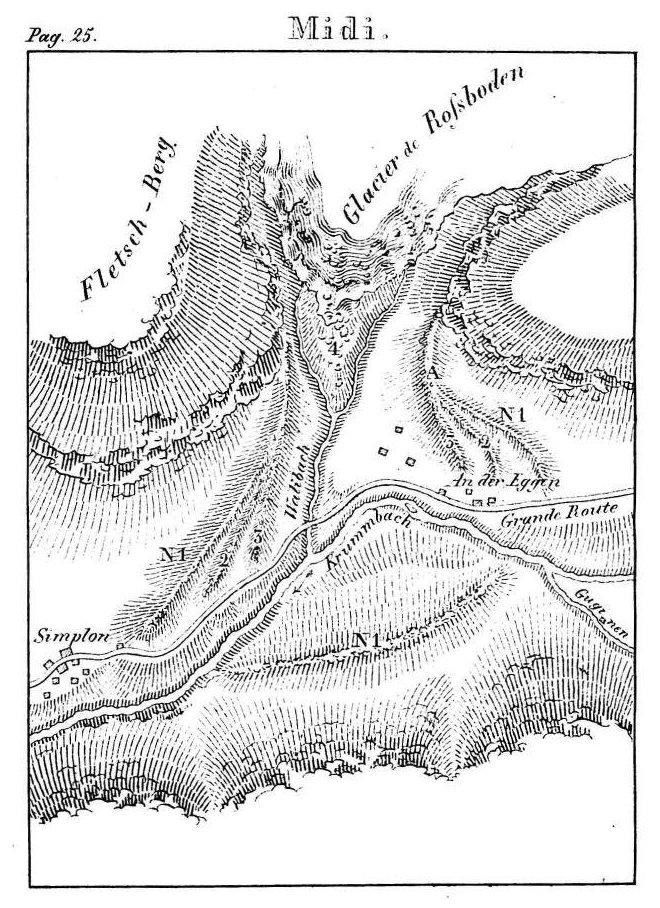
Travelers who want to examine these enclosures, should stop at the An-der-Egguen village built on debris of this kind. They will go up behind the village onto a hill which is about 600 feet from the road (see point 'a' on the drawing attached). Here a huge moraine is divided into three, the later clearly demonstrates that having met with the opposite hill and unable to advance, the glacier has been forced along its flanks, laying all around a very large moraine (see No. 1), by which one can clearly judge that, in the place where the Simplon highway crosses the Wali stream (Walibach), the glacier was once over 200 feet thick.
Advanced less far than the first, the other two moraines are distinguished only on each side of the ancient glacier, their peak was swept away by the torrent, or some other cause. That fact proves that many moraines were destroyed by causes unknown to us, and it should be no surprise if there are many glaciers where the vestiges of their former size have completely disappeared.
Scutelaria alpina. At Frenjoley : Geranium divaricatum. Above Courtier : Agrestema flosiovis, viola saxatilis. At Matzeria : Fumaria fabacea, not far from the snow. At Cepi : Saxifraga diapensoides. Above the Mauvoisin bridge : Betula nigra. On the Mauvoisin : Ranunculus pyrenaeus et var.plantagineus ; Thlaspi montanum. Opposite the Oratoire: Arbutus alpina ; sisymbrium tanacetifolium ; saxifraga petacea avec la var. Bellardi ; gentiana hybrida. En Torrentbosse : Serratuta alpina; sedum anacampseros et villosum ; astragalus leontinus et Halleri ; this latter also grows in abundance at the foot of Cessetta glacier with Herniaria alpina. At the Alia : Saxifraga diapensoides , among the rocks, and carex microglochia, in the marshes. Higher up ; Potentilla minima, of an extraordinary grandeur ; saxifraga biflora. At Giétroz facing the Alia : Carex bicolor ; potentilla nivea ; draba hirta ; sisymbrium acutangulum. On the ancient moraine of the Lire-Rotzo glacier : Potentilla frigida. At Tzanrion : Lychnis alpina ; artemisia glacialis, nivalis, spicata; arenaria recurva v. hispida ; gnaphalium pumilum, pussillum , leontopodeum ; Potentilla nivea ; Achillea nana; Pedicularis rostrata; Antherinum serotinum. On mounting the col de Fenêtre: T. Arabis coerulea et serpolifolia ; Gentiana punctata ; Aira subspicata; Avena disticophylla. Geum reptans among the rocks of Cret.
The entomologist will find near the Giétroz glacier : Doritis delins et mnemosine ; a beautiful variety of Pontia callidice; Hipparchia aello, pitot, arachne, goante, gorge, manto, maestra, alecto , cassiope, melampus, pharte satyrion. Melitaea cynthia ; Argynnis dia, pales, euphrosine ; Lycena orbitulus , pheretes ; Zygaena exulans ; Lythosia ramosa ; Geometra turbata , etc.
The conchologist ; Helicomax vitrea de Ferussac; a fine variety of Helix arbustorum et sylvatica ; Hélix holosericea , ruderata, cristallina, montana ; Bulimus montanus ; Clausilia fragilis , etc.
............................................................................................
26
A fourth moraine is still found close to the glacier (excluding irregular masses of stone found in the gap), it is covered with larch of a small size, of which the ice has already toppled much * ).
From moraine No 1 to the present-day ice, there is a distance of about 7000 feet.
It may be objected that this glacier has formed the moraines by sudden rock falls of which history makes mention. It is incredible that a rock-fall can form such regular moraines. Nor indeed is it Rosboden glacier which collapsed, it is that of Gutschen which, towards the end of the last century, has once again collapsed and covered the ice of the Alps of Gugguinen and the Gletsch plain. Debris caused by these falls is scattered in confusion in the plain.
17. Sirwolten glacier has similarly left behind to its left, in the mountains of monsieur Theiler de Brigue, below the old hospice of the Simplon, three moraines not difficult to ascertain. They are a good league from the current glacier, which is located on the hill beside a small lake, whose waters are the color of whey, from which comes the name of Sirwolten-Sée et Sirwolten-Gletscher **).
18. On the right side of the Eauxfroides glacier (Kaltwassergletscher), about thirty feet from the glacier today, we saw, in 1817 an old moraine. We are sure that the glacier has not reached it since that time.
19. The chalet of Lorenze situated near the Rawyl d'Ayent road, is a plain formerly occupied by the Tenay glacier, which at this moment, does not descend from the height of a rock that closes the amphitheater-shaped valley. There is a large moraine covered with tall larch between the said cottage and the granary of Rawyl. From the said moraine at the foot of the glacier, it is a good league's walk, and a height of about five hundred feet.
20. The Osser glacier in the Hermence valley has left large moraines, of which the most distant is currently a good half-league from the ice. During
*) After 1822 this glacier has abandoned a large area of land.
**) Sirwolte, signifies in the language of Valais [Walliser German] : whey.
............................................................................................
27
such an increase it met a mound-shaped rock that almost split it in two. The right side, being the largest, has advanced on a precipice, and pushed a large amount of stones to the bottom of the valley. This part left behind on its left a moraine over one hundred feet high. We see by its divided end that it has been deposited at different times. The left side of the glacier has not advanced as much. The moraine is divided into two towards the lower end and reunites, in approaching, at the mound.
On the right of the part of the glacier which had reached the precipice, the corresponding moraine is very visible. On this point of the old glacier, one can see very clearly a second moraine which has not passed the precipice, it goes around a pretty little valley about 300 feet in diameter, covered with greenery and has become almost round, the valley is closed at the top by a pile of stones, which one would take at first sight for two very recent moraines, but that seem to us more likely to be descended from the rocks that dominate the right side of this valley. At the top of this heap of stones, against the place where the glacier has met resistance, one finds yet another pile of boulders scattered, but one can not determine whether it is a very recent moraine, or a rock-slide.
On the side of the chalets of the Ossera, one sees the remains of a moraine older than those just mentioned, and of which one cannot follow the traces.
21. At the foot of the Corney glacier, in the same valley, one sees a distinct moraine, which was left firmly pressed against a large rock that is on the left side of the valley. From this rock to châlet de Métal, we see a large mound terminating in an elongated ridge. We might take it for a moraine. In that case, there would still be a second glacier on the right side of the valley, which would be joined with the previous one. We make no claim however that this mound was an old moraine, despite first appearances *).
Inside the moraine cited at the beginning of this article, there are more irregular masses of stone, also pushed by the Corney glacier. A third moraine is found on its right, it descends about 300 feet lower than the present glacier.
*) The observations which we made after 1822, persuaded us that it really is one.
............................................................................................
28
22. On the left of the Combaly glacier, above the mountain chalets of Aleva, in the same valley, there are moraines that descend about 2000 feet lower than the existing glacier.
A quarter-league above the chalets of Aleva, can be found debris that would indicate a moraine deposited at the end of a glacier. It even seems that the water in this valley passed once through the middle of the debris, and that landslides, descending from the right of the valley, forced it to the left.
From here, one climbs for half an hour, walking on a rise ending in a ridge, which one could take on the moraine to the left of a glacier. Then we come to a rock of which, the part that the glacier has reached, is totally devoid of crushed rocks, while the rest is entirely covered. It is on this rock, that one distinctly sees the moraines, of which we have already spoken. They are in a basin which is about three leagues in diameter.
If the glacier reached a quarter-league from the chalets of Aleva, which appears to us very probable, yet it would not be until after it had filled after the said basin. Rose glacier, found on the left on the height, woul be attached to it. However, we have not seen old moraines around the latter glacier : phenomenae we have observed in almost all glaciers, which are now found in the regions situated at 7000 feet above sea level.
23. We also see old moraines with the Mortier glacier, in the same valley. The one on the left is not far removed from the ice, and those that one sees at the base of the glacier, are about three hundred feet from it.
24. The end of the Ecolay glacier near the previous one, is about 800 feet from a small moraine, which is difficult to distinguish. This glacier entrains few rocks, and wherever there are more, they fall into the stream, so that the moraine cannot retain them. On the left flank of the glacier, one easily distinguishes, by means of scattered rocks just how far this glacier once stretched. It originates from the north of Mont Pleureur which, with the Giétroz separates the valley of Hermence from that of Bagnes.
We have not been close to the glaciers of the Sale, of the Lincresse and of
............................................................................................
29
Durant (the two latter are are very large, located deep in the said valley); from afar we have seen moraines only to the right of the Durant glacier, but the one that is there, is at little distance from the ice.
25. The chalet on theTauno mountain, above Lugg village, Anniviers Valley, is located in a site formerly occupied by the Combava glacier, which now ends about 6000 feet higher. The moraines of this glacier can be quite well discernedl all around the old glacier. We see from afar that the left divides in two.
26. The glacier of Durant in Tzina, at the base of the Anniviers valley, was formerly larger than at present. It is found on the right of the Navisenche, which leaves this glacier, four moraines are deposited on a rock which retain this glacier, and leave nothing but a narrow passage to the stream which escapes through a crevasse about one hundred feet deep .
The longest of these four walls is about 300 feet from the ice : it is covered with larch trees of a very great size. On the second, the larches are half the size, the third has none at all, and the fourth, which is the last, was, on the 16th of September 1821, six feet from the ice.
27. On the left of the Mumin glacier, which is on the right of the above, we see below a moraine which the glacier has not yet reached.
28. We have see, in 1815, on the left flank of the Gorne glacier (Gornergletscher), at Zermatt (Praborgne), Viege valley, and on the same flank as that of Tzmut, some very distinct old moraines. We are sure that these glaciers have not yet reached them.
29. Ried glacier, near St.-Nicolas, same valley, descended once a good half a league lower than at present. According to M. Schallen, former president of Viege district, one can still see several walls deposited by ice.
30. On the left of the Fiesch glacier (Viesch), facing the Stock mountain, at the foot of Mount Richiguer (Richigerberg), Conches valley, one finds a moraine in a depression which is much higher than where the glacier was in September 1820 *). This moraine, however, is far too low to correspond with a second, located on the left side of the Fiesch valley
*) Others are found approximately 1200 feet below the lower extremity of the glacier : they are covered with bushes.
............................................................................................
30
at 300 to 600 feet above the plain. On this moraine the villages of Ried, Bodmen and Halten are built, all belonging to the parish of Bellwald. The greater part of the village of Bodmen occupies that part of the moraine, which leans against Mount Bellwald; that of the Halten is found towards the end of the moraine, at that height.
Judging from this demarcation, Fiesch glacier must have been of such an enormous size, that it is impossible to have an idea of it without having been at the scene, and it was only after having examined it the third time, and from different points of view, that we were convinced of the existence of the moraine.
Also it is the only place, where evidence from the past indicates that the glaciers were once larger than they are at the present time *).
At Fiesch some say that the glacier used to come down right to the church, while others affirm that it had even advanced to Brigg, near Lax. The moraine which we have mentioned, does not indicate such length, its border indicates an extension of over 12,000 feet beyond the village of Fiesch.
This glacier has a huge basin in the upper zone and must move more than those we have mentioned so far, when there is a decrease in temperature.
31. The glacier which is located on the Stralhorn, facing the Fiescherbom, same valley, has left behind at the base, to its left, a moraine half a league from the current glacier.
32. The Aletsch or Maeryelen (Marjelensee) lake which is below the above-mentioned glacier, was formerly fully occupied by the Aletsch Glacier. One still sees on the side of Fiescherhorn, at a considerable height, the moraine which has remained above the lake which, after having made in July 1820 a breakout across the Aletsch glacier, has left a pool of 4833 feet in length **).
*) We believe that this theory has been established by the evidence of the moraine, because when the glacier deposited it, the Conches valley must necessarily have been uninhabitable, so a tradition has not communicated from father to son.
**) This lake has broken out again in 1822 and 1828. The government of Valais is accordingly concerned with digging a channel to lower the water level by twelve feet and to reduce the volume of water significantly, by this means.
............................................................................................
31
33. Messieurs de Saussure, Gruner, Wittenbach and Ebel *), famous naturalist, have observed with us that the Rhone glacier in the Conches valley **), those of Grindelwald and Lauterbrunnen in the Bern canton, and that of Bois à Chamouni, were formerly larger than at present.
It may be objected that these glaciers have increased since these philosophers made their observations. We have not however heard that the Bois glacier has reached the road leading from the village of Prieuré to that of Argentière, and as there are so many glaciers that still do not approach their former moraines, we do not think that these are less distant than the others.
34. In ascending from Oberguesteln onto the Grimsel, one encounters before reaching the small stream of Raeters, which is a quarter of a league from the summit of this mountain pass, the walls of a glacier which exists no more. It parts to the south of the Sidelhorn. (Having visited this place a second time, on the 22nd September 1826, we found only a few small piles of snow). The left of the moraine is visible from the naked rocks just below the road to Grimsel, where it immediately divides into four, not to mention other small irregularities.
*) De Saussure, Voyages dans le hautes Alpes, §. 541 et 623.
Wittenbach, Beschreibung des Lauterbrunnenthales. S. 14.
Ehels Anleitung die Schweiz zu bereisen. S. Grindelwald und Furca.
**) we have visited this glacier, on Sept. 22nd 1836. Here are the distances paced out, which we found between the old moraines and the glacier :
The moraine furthest from the glacier leans against a rock, forming a mound, on which are built mountain chalets. It presents a great width over a height of about twenty-two feet. From the inner side of the first wall to the middle of a second, we found a distance of thirty feet. From that to another, almost imperceptible, forty-five ; from that to a larger one, ninety ; from this fourth to one following which is about eighteen feet high, two hundred and forty-three feet. Close to it we found a small one, ehic we have included in the distance to the next, which is five feet tall, and is two hundred and forty feet from the large one. On the right side of the valley, this moraine divides into three or four near the middle. From this moraine to another, four feet high, ninety feet. That one forms a series of moraines piled irregularly against each other, over a distance of three hundred and sixty feet, rising almost imperceptibly to the height of twenty feet or more. This assemblage of a quantity of moraines describes an arc and they meet on the right, at the latter, without reaching the foot of the mountain. Here the Rhone emerges from the glacier, crossing the last wall that it has formed, then it follows the previous one into the middle of the plain where it cuts it like all the others.
............................................................................................
32
Not far from the road is a granite upright like a column, and which is placed as if by falling into a slit that was leading into the ground. At least we are acquainted with no other natural event that could have placed it that way.
A second Moiraine is about one hundred and fifty feet to the east and does not descend as low as it. We find its lower end by a contour that the road has made. After climbing it, we find a small plain, and one may walk for some time over the bed of this ancient glacier.
It is easy to judge the width of the ground occupied by the glacier by the rocks that it has laid bare, on which there are only a few weak grasses, while the surroundings are covered with large amounts of rock debris , gravel, etc.
From here we thought we could make out the walls of a second glacier that would be found a quarter-league to the west of it, but we did not have time to go there.
______________________________
Here we are at the end of enumeration of glaciers which no longer exist, or once were obviously larger than at present. We are sure that
From the place where the Rhone traverses this mass of moraines, to the most recent, the distance is some three hundred feet. On the left of the center of the glacier, it seems it had covered an older moraine : because one can still see grass.
In those days, the ice was ten feet from the last moraine. On the left of the Rhone, by way of contrast, this distance is several hundred feet. This circumstance, we attribute to changes experienced by the Rhone River at its outlet from the glacier, and that the stones, which it entrains in its course, are sometimes thrown on one side, sometimes the other, undermining the glacier at its base and destroying it in a higher proportion in this place which did not allow the same advances, when the glacier was greater.
From what we have said, it follows :
1) That on the 22nd of September 1826, the lower end of the glacier was one thousand four hundred and eight feet from the first recognizable moraine, which one finds in ascending.
2) That at that time there were nine very distinct moraines.
3) That many of these walls were formed at different times, that is to say, after having retreated for some time, the glacier sometimes advanced and augmented the moraines that it had formed before.
4) That the distances from one moraine to the other are unequal, and that their respective sizes show that the periods of their formation were separate, and unequal, as well as the degree of cooling.
............................................................................................
33
in the Canton of Valais alone, one will find many more moraines just as striking as those just mentioned, if one had time to travel through all the side valleys of this country.
We have seen many glaciers where we found remains of this kind of deposits ; such are the glaciers of the Neuva and Planereusa, in the Ferret valley, that of Hautemma at Bagnes, the glaciers of Rosé, of Praflory, of Darbonaire, of Jodry and of Merdery in the Hermence valley, etc.
At several of these glaciers as at Tzanrion, ahead of that of Hautemma, we sometimes find the scattered stones of a species that do not belong to the local rocks. Others are located on high ground, where the debris that glaciers grow in front of them, can not long refrain from avalanches. Finally, who can know all the causes which tend to destroy these ancient monuments of cooling? And how many might not have been found, if there were not presented to the eyes of the naturalist, who traveled these places, so many other interesting objects that occupy him so much, that these more or less visible hills evade the scrutiny of his eye?
How is it there are not small lakes on the mountains, which would likely be filled with earth and stones, if long ago the glaciers had not seen them cleaned out?
We have found in many places glaciers, where these moraines have appeared recognisable, yet difficult to distinguish ; as at the foot to the right of the Belaval glacier in the enclave of Mount Jovet in Tarentaise, at the bottom and between glaciers in the place called 'the glaciers', in the same country at the base of the Montdolin glacier in the Ferret valley in Valais, from the Eudon glacier coming from Diablerets ; on the Sanetsch, where the moraine appears on the left of about 5000 feet of ice from which the rocks are bare up to the glacier. On the Châtelet (Steig) side on the height of Sanetsch, it was found on the left side of a valley, in the month of September 1820 that no more than a very small pile of snow existed, an elevation which might be taken for a moraine.
In examining on this mountain the Plan-Germandre and the mounds on its left, one will be led to believe, that the small glacier of Creux would have occupied this plain. Also the mounds and piles of stones, which are seen at the entrance of the valley of this glacier, resemble moraines, since above them
............................................................................................
34
the rock is totally swept to the glacier. The chalets of mount Genievre, situated between the glacier and the Plan-Germandre, were however crushed by a fall of rock coming from the left of the valley.
It is the same with Trient glacier, where the village and the chapel of that name appear to be built on moraines of that glacier *).
Almost facing Obergestlen, Conches valley, the Éguinen (Eginenthal) valley begins by which two passes lead into Italy, proceed by way of the Gries and the Luvino.
At the foot of the mountain, where one finds the said valley, to the west of Zumloch village, there are three different rises similar to those of moraines, which owed their origin, to the overflows of the Eguine, or a glacier. On the right side of this valley, a very considerable height (300 to 350 feet above the river), there is a large pile of stones, forming, with the bottom of the valley, a parallel line in all respects similar to that of a moraine. This place deserves to be better examined, because the Eguine glacier is two leagues from the place just cited **).
________________
Going by the facts in this memoir, the theories which have been contradicted, of which some presume a cooling of different parts of the globe, for example, in England where the cultivation of vines had to be abandoned, while according to others, the Baltic and the Black Sea were frozen solid ***), have just been confirmed in a very remarkable manner.
On the one hand twenty-two observations, more or less verified, tend to show a considerable lowering of the temperature ; on the other, more than thirty-five well-proven facts seem to demonstrate its elevation.
It therefore appears certain that the temperature rises and falls periodically, for the contradictory facts, which occur in a single place, as at the Col de Fenetre, at that which is between Praborgne and Hérens on the Simplon
*) The observations we have made since 1822, assure us that they really are moraines.
**) From observations afterwards we proved that these are really piles of ice.
***) We intend to write a memoir soon, by which we shall try to prove they were, in effect.
............................................................................................
35
and on the mountain which separates Fiesch from Grindelwald, where one finds much-frequented passes *), while the glaciers of the Col-de-Fenetre, of Montdurant, of Rosboden, of Tzmut, of Fiesch, of Stralhorn and of Aletsch were much greater than they are these days **), cannot be of the same period.
It is also likely that the era, where the temperature of Switzerland was much higher than today, is separated by many centuries from those which have left traces of so great a cooling, of which we often find much evidence in front of a single glacier.
The forests that we found on the moraines of several glaciers, their age, fruit trees and vines, which we have mentioned in this paper, will serve to support this hypothesis ; because it takes a long time before the forests can grow on a newly formed moraine, before the walnuts will have grown so high that we can put a tax on their product, and we have almost no memory of their existence. Also the stocks of vines live long after the abandonment of their cultivation.
We have no doubt at all, that it has occurred several times, when our climate was much colder than at present ; since we do not doubt either that there have been those when it was considerably warmer, and the temperature rises and falls periodically. But what is the cycle of these periods? What are the causes that have produced change? The facts that indicate a rise in temperature, are they older than those to the contrary? These are questions on which we cannot establish a hypothesis.
The data needed to determine the cycle of these various periods, including the facts that we have just quoted, indicating such a great difference in temperature, we lack entirely. It is only through accurate and checked observations, that we may be able to set about establishing it approximately. It would be especially important to observe, how much time would be necessary, before the trees begin to grow on the new walls of the glaciers, for example, that of the Prenva glacier on the Allee-Blanche,
*) See II, IV, VI, X et XI.
**) See numbers 11 , 12, 16, 17, 28, 30, 31 et 52. The last three glaciers are interrupted on the same pass.
............................................................................................
36
where ice toppled, in 1820, trees of two hundred and twenty years and older. By adding this to the time it took for the growth of the largest trees found on the moraines, we may perhaps, approach that which has passed since the formation of such a moraine, especially if found in nearby forests of very old trees ; and as there are glaciers with which we find many of these moraines, perhaps we would find the difference in their ages.
The size of moraines can be used to tell us about the time that has elapsed from the laying down of one to that of the other.
Wherever we have seen several moraines before a single glacier, the one that is furthest from the glacier is the largest. Since all the debris which fell on a glacier before the formation of such a wall can be found there almost reunited, it serves to indicate approximately the time that has elapsed since any catastrophe, in which the mountains were swept clean of their debris *).
It is likely that the rocks of any mountain decay in nearly equal proportion, we can therefore, by their size, judge roughly the time elapsed between the formation of these different moraines, if we can discover that which elapsed from the penultimate to the last.
Here, history, literature and even popular traditions can serve us. One would therefore hope that the naturalists would give it some attention. Meanwhile, one can judge by the differences of these moraines, that the march of epochs that produced them is irregular.
The causes of these temperature changes are even less known to us, since astronomical calculations have shown that precessions of the ecliptic probably did not produce them.
The increase or decrease of forest seems too weak an influence to produce this change in temperature. Forests have declined for three centuries, and the temperature fell at the same time ; the destruction of forests ought therefore to produce a cooling, while in America their existance refreshes climate **), which is a contradiction.
*) We propose to return to this subject in another memoir.
**) "If the part of the New World, which is located between the Tropics, has no Negroes,
............................................................................................
37
Even assuming that the forests can influence the melting snow and glaciers, it would have the result that they would duly have been destroyed and restored each time these large variations in temperature have occurred ; that however is unlikely .
As to the facts that indicate a rise in temperature, we believe that there are some which are earlier, and others which are later than those which indicate a cooling. These are the moraines of the Rosboden glacier on the Simplon. Those that the highway crosses, seem to us to be older, that the temperature was much higher than today ; because at that time the Simplon had to be completely closed. In contrast, those closest to the glacier seem to be from later centuries, as it is possible that wind and other local causes can produce small variations.
The road from Domo-d'Ossola to Brigue once passed by Varzo, Trasquera, Frassinodo (Alpien) and Simplon (the last three villages are found at nearly the same height). At Frassinodo there is still a discount for the deposit of salt and goods. It is likely that it is only since the invention of gunpowder, that it has avoided Trasquera and Frassinodo, in passing via Gondo.
According to Lieutenant Colonel Perrig Brig, you can still see on Simplon mountain three dates carved in the rock, indicating the changes that have been made to this path. The earliest date is 1312, the next 1557 and the third is 1758. It seems that fromtime immemorial, this path has always passed through the little village of An-der-Egguen ; because we do not see anywhere traces that can indicate the opposite. These traces would have been noted if that had happened ; for wherever the road was changed, one still finds the old ones.
The buildings of this village and a chapel, however, are built on the said moraines ; they appear to pre-date the time when the road passed by Trasquera and Frassinodo, a time which left us evidence of such a high temperature.
"It is because the heat of Peron is 15° lower than that of Senegal, decrease that must be assigned to nitre of the American humus, to airs impregnated with sea salt and especially the huge forests with which this continent is covered." Recherch. philos. T. 1. second part, sect. I.
............................................................................................
38
This is how we shall endeavour to support this hypothesis :
The Bell of Grindelwald *) from the chapel of St. Petronilla, formerly located next to the road that leads to Fiesch, dated 1044. The passes of Saas in Antrona and Macugnaga were already very old in 1410 **), and the Simplon had experienced a change in 1312. It may be assumed that the high passes of the Alps, which we mention in this memoir, were all open at the same time.
According to M. Zurbrigguen, it was only at the beginning of the seventeenth century that the mountain passes became difficult. He does not however say that they were blocked ; and it was only in the eighteenth century that they became inaccessible to horses. But as most of the moraines of which we have spoken, indicate a much more intense cold than today, it seems that history ought to mention, if cold weather had arrived at that time ; since, in that case, the roads would have been closed even more so than nowadays.
We are therefore as it were permitted to believe :
1) That the moraines which are found at a considerable distance from the glaciers, date from an epoch that is lost in the mists of time.
2) That the facts we have cited to show a decrease in temperature, are more recent than the said moraines.
3) That those found near glaciers are from the last two centuries.
4) That the temperature rises and falls periodically, but in an irregular manner.
5) That, according to appearances, the cooling of this period has come to an end.
6) That the glaciers reach with difficulty to a gigantic height, of which we find so many remains, and that we can reassure ourselves about the presumed extension of the region of ice in general.
*) See VI in this memoir.
**) See VIII.
............................................................................................


Comments