


NASA's Aqua satellite passed over Tropical Cyclone 15S as it formed in the Mozambique Channel on Feb. 18
at 10:53 a.m. EST
and the Atmospheric Infrared Sounder
(AIRS) instrument aboard gathered infrared data on its cloud top temperatures and potential.
The data on the tropical system showed the highest cloud tops and strongest thunderstorms were in a band that stretched from the east to the south of the center. Cloud top temperatures were near -63F/-52C, indicating high, powerful thunderstorms with potential for heavy rainfall. The eastern-most edge was over western Madagascar and the southwestern extent reached Mozambique on the African mainland.
On February 18 at 1500 UTC/10 a.m. EST, Tropical Cyclone 15S had maximum sustained winds near 35 knots/40 mph/62 kph, making it a tropical storm. 15S was centered near 18.3 south and 40.3 east, about 375 nautical miles/431.5 miles/694.5 km west of Antananarivo, Madagascar. It was moving to the south at 5 knots/5.7 mph/9.2 kph and is expected to strengthen to hurricane-force over the next couple of days. It is generating 10 foot high waves in the Mozambique Channel.
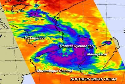
NASA's Aqua satellite passed over Tropical cyclone 15S on Feb. 18 at 10:53 a.m. EST. The highest cloud tops and strongest thunderstorms (purple) were in a band that stretched from the east to the south of the center. Credit: NASA JPL, Ed Olsen
Forecasters at the Joint Typhoon Warning Center expect 15S to drift south through the Mozambique Channel over the next couple of days and emerge in the Southern Indian Ocean in cooler waters.


Comments