Banner
By Patrick Lockerby | July 27th 2010 04:57 AM | 22 comments | Print | E-mail | Track Comments
About Patrick

Retired engineer, 60+ years young.
Computer builder and programmer.
Linguist specialising in language acquisition and computational linguistics...

View Patrick's Profile
Arctic Ice July - Update #5

The sharp decline in ice extent slowed somewhat during July.  Some people are claiming this as a sign of recovery.

If you are going downhill at full throttle and you take your foot off the gas you will slow down.  A bit.  But if the brakes aren't working you are in for an exciting time.

Loss of ice extent has slowed down.  A bit.  In plain language: loss of ice continues to be a lot more rapid than has been considered normal historically.

Almost the entirety of the main Arctic Ocean ice cover shows substantial amounts of open water.  The ice is freely mobile in most areas.  Both the North West Passage and the Northern Sea Route, aka North East Passage seem to be easily navigable by icebreakers.

Plans are in hand to take traffic through the Northern Sea Route.  Two oil tankers recently collided en route from Murmansk to Chukchi Peninsula, apparently without suffering too much damage.
Although the two tankers were the first to sail the North East Passage this summer, they are not the only ones earmarked for a passage.

Sovcomflot intends to carry out the first major oil shipment from the Varandey terminal on the coast of the Pechora Sea through the North East Passage to Japan later this summer.

The shipping company will use one of its purpose-built 70,000 dwt ice-classed shuttle tankers.

If the trial is successful, the vessel will be the first ever oil tanker to sail the entire Northern Sea route from Northwest Russia to Asia.

http://www.tankeroperator.com/news/todisplaynews.asp?NewsID=2102


Some adventurous sailors are planning to attempt both routes in small ships this year.
Several sailboats will try to go through the Northwest and Northeast Passage this Arctic summer. It is not a given that they succeed, says Arctic ice expert and adventurer Knut Espen Solberg.

http://explorersweb.com/oceans/news.php?id=19526


The North Pole web cam

This part of the article was inspired by discussions in a comments thread on Neven's blog.

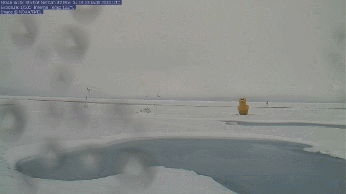
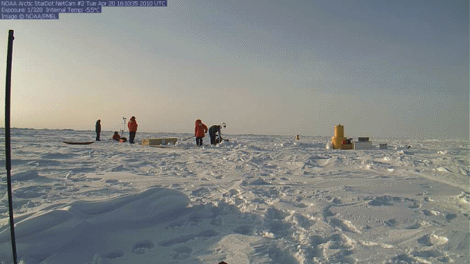
Two cameras were placed on a floe near the North Pole early this year.  I have made an animation of some key events captured by camera #2.  There were many days with snow.  I have omitted those many boring shots of snow on the camera lens.  You can tell when it has snowed by looking at the snow line against the large buoy.  The image below shows points to focus on:

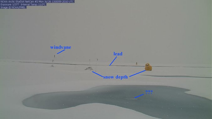
The lead can be seen opening in the animation.  The relative motion of the two floes is demonstrated by the relative motion of the two buoys at right.  The motion is not dependent on wind direction.

In the center of the meltpond is a feature marked with three queries.  I think that this is a hole linking meltwater and ocean.  This next image shows a before and after shot which seem to show a change in water level in the meltpool.


The hole first appeared in an image from July 21 01:09:43.  Prior to that shot the lens was too much obscured by snow to see the meltpond clearly.  At the time the hole appeared there was substantial relative ice motion and the nearest buoy tilted towards the camera.  That tilt continued afterward.  Note especially 'shoreline' at right and at front right.

Now that you know what to look for, here's the animation.  The first frame shows the people deploying the experiments.  I have included it to give a sense of scale.

Animation of selected images from:
http://www.arctic.noaa.gov/gallery_np.html

Note how the snow builds and levels the scene.  After the meltpool forms it is sometimes fringed with thin ice.  Snow occasionally falls on the thin ice but does not persist.  At no point does the meltpool freeze over entirely: if it did it would be totally covered with snow at some point.

Judging from the lead, and assuming the pool is connected to the ocean below, this floe is now less than 1 meter thick.  Note the apparent crack at right in the last few frames, between the two meltwater pools.  Could this floe be in process of breaking up?


How thin is the remaining ice?

Last year the multiyear ice was effectively gone by the end of October.   There seems to be a principle of 'late to grow - early to go' at work.  New ice formed very late last year in Hudson Bay and the Barents Sea as reported by NSIDC.  There was a brief spurt in early April which vanished rapidly.

It seems to me from the way the ice has fragmented and dispersed generally that most of the newer ice which forms between floes in winter has either melted or fragmented.  Mobility in the ice as reported historically by explorers was a matter of leads opening and closing and of ice forming piles and ridges.  Leads are cracks which form when ice is placed in tension.  When large masses of ice press against each other the ice thickens through ice riding over ice, or through the formation of compression ridges.

When a floe is over-ridden it can be swamped: pressed below the water surface.  This is referred to as 'negative freeboard'.  The water overlying a swamped floe can ice over.  This form of rotten ice can appear to satellites as thick multiyear ice.  A survey last year found a lot of rotten ice.
Barber et al.: In situ observations from Canadian Research Icebreaker (NGCC) Amundsen indicate that the multi-year sea ice pack in the Southern Beaufort Sea was not as ubiquitous as it appeared within satellite remote sensing data products in early September 2009. A large sector of what was remotely sensed to be multi-year sea ice at 7 to 9+ tenths ice cover, consisting primarily of multy-year ice floes, was in fact a surface of heavily decayed ice composed of some small multi-year floes (1 tenth) interspersed in a cover dominated by heavily decayed first-year floes (1 tenths) and overlain by new sea ice in areas of negative freeboard and in open water between floes.

http://www.arcus.org/search/seaiceoutlook/2009_outlook/2009_pan-arctic_s...


Regardless of what some people are desperately trying to convey to their uncritical audiences, the Arctic is most definitely not cooling.  8000 years of cooling has come to an abrupt end as the Arctic warms at a speed which should give any rational human being cause for concern.

"The Arctic is an early indicator of what we can expect at the global scale as we move through the next few decades ... So we should be paying attention to this very carefully,"

David Barber,
Canada's Research Chair in Arctic System Science at the University of Manitoba


http://www.reuters.com/article/idUSTRE59S3LT20091029


Coming soon:  Arctic warm water influxes - how warm is the Arctic Ocean?


More articles on the Arctic and related topics:
The ChatterBox Arctic Index

Recommended related blogs and articles:

Neven on Arctic Sea Ice - interesting news and data:
http://neven1.typepad.com/blog/

Mauri Pelto on glaciers:
http://glacierchange.wordpress.com/2010/07/26/lemon-creek-glacier-retrea...

Dirk Notz on Arctic Sea Ice - hat tip to Artful Dodger for the 'heads-up'.
http://www.realclimate.org/index.php/archives/2010/07/an-icy-retreat/

Comments

logicman
While I was writing this article, unknown to me Neven was also writing about the NW and NE passages.  I have already done enough edits and proof-reads to tire me out for the day, so here's the link in a comment:
http://neven1.typepad.com/blog/2010/07/passing-the-passages.html


Neven
Great stuff, Patrick. No need for me to upload that webcam video to Youtube anymore. :-)

Coming soon:  Arctic warm water influxes - how warm is the Arctic Ocean?

Can't wait for this one. I have been saving these NCEP SST images for a few days now. Let me know if you can use them in animation form of whatever for this article.

logicman
Thanks for the offer, Neven.  I keep forgetting to check that site.  I could use a GIF animation of about 14 days worth later.  Let's swap emails.

btw, my animator lets me set timing properties per frame.  I find that adding more delay front and back makes it easier to spot the start and end when it loops.

Here's today's SST.  It corresponds nicely with the MODIS images if you take purple as showing significant amounts of ice.  The bit in the middle looks suspiciously circular: I guess that's just infill for missing data.


image source:
http://polar.ncep.noaa.gov/sst/ophi/color_sst_NPS_ophi0.png


Hi (Prince) Patrick,

I wonder if you've seen this archive of Arctic SST anomalies? The data covers each month from June 2002 to present. The Jun-Nov 2007 sequence is especially interesting:

http://sharaku.eorc.jaxa.jp/cgi-bin/amsr/polar_sst/polar_sst.cgi?lang=e

Looking forward to your SST blog post!

logicman
Thanks, A.D.  I'll have a look.

The Arctic Dipole Anomaly plays a role as well with the decline of sea ice.
It was in force back in June, but lately little ice is being exported.
No idea when it will be back, but if it does watch out!

http://adsabs.harvard.edu/abs/2008AGUFM.C51A0538W

http://nsidc.org/arcticseaicenews/2010/070610.html

The Arctic dipole anomaly
The record low ice extent of September 2007 was influenced by a persistent atmospheric pressure pattern called the summer Arctic dipole anomaly (DA). The DA features unusually high pressure centered over the northern Beaufort Sea and unusually low pressure centered over the Kara Sea, along the Eurasian coast. In accord with Buys Ballot's Law, this pattern causes winds to blow from the south along the Siberian coast, helping to push ice away from the coast and favoring strong melt. The DA pattern also promotes northerly winds in the Fram Strait region, helping to flush ice out of the Arctic Ocean into the North Atlantic. The DA pattern may also favor the import of warm ocean waters from the North Pacific that hastens ice melt.
June 2010 saw the return of the DA, but with the pressure centers shifted slightly compared to summer 2007. As a result, winds along the Siberian coastal sector are blowing more from the east rather than from the south. Whether or not the DA pattern persists through the rest of summer will bear strongly on whether a new record low in ice extent is set in September 2010.

logicman
The Arctic Dipole Anomaly plays a role as well with the decline of sea
ice.


Indeed it does, Andrew.  Thanks for the links and the quote.  I think the Arctic dipole anomaly merits an article of its own.  I'll see if I can make time for it.

The North Pole Web Cam is currently located close to 88 degrees north, only about 60 miles from the north pole.

In the past years, the cam made steady progress towards the Fran strait, and would normally be alot farther south, by this time. This year, it is staying close to the pole.

This is the first year, that the web cam actually reflects conditions at the pole (or near to it). This would explain the constant wet snow falls that have been happening earlier than normal, and which would probably be rain farther south near the fran strait.

Despite being so close to the pole, the ice is obviously thin, and the whole site is in danger of breaking up and the equipment sinking, especially if stormy weather with high winds develop.

logicman
Lord Soth: thanks for the input, and for reminding me that I forgot the drift map.  Here it is, better late than never:


Drift map for webcam #2 - PAWS track in red.
Downsized from image at:
http://psc.apl.washington.edu/northpole/DriftTrackMap.html

Some meltpooling on N Greenland, more on NE.

logicman
There are huge areas containing meltwater pools on Greenlands ice margins.


The area marked Z is Zachariae glacier.  Here's a close-up:


Hi Patrick,
Great blog. Given your interest in Arctic history, I thought you would be interested in this recent story from CBC: http://www.cbc.ca/canada/story/2010/07/28/hms-investigator-arctic.html. Archeologists have located a ship lost in the Northwest Passage 150 years ago. The ship, the Investigator, was trapped in ice for 2 years before being abandoned in 1854. The area is now open water according to this story. Times are changing.
Josh

logicman
Josh: thanks for the link.  I had seen that already and have written a related article: Arctic
Heroes #3 - Robert McClure.


Times are changing indeed.

Please feel free to link anything Arctic related that you think may interest me and my readers.  You are bound to be ahead of me sooner or later.  Most of my readers are. :-)


Hi Guys,

It may not have your interest, but tonite (July 28, 2010) Boerge Ousland and Thorleif Thorleifsson will be leaving from Murmansk on their “The Northern Passage 2010” expedition / voyage, following the Norwegian tradition of “great trips” which I as a Norwegian just can envy in a positive way.
This trip will lead them thru the North East and the North West passage in a trimaran, the first big challenge, after Russian bureaucracy, will be the Vilkitsky Strait into the Laptev Sea which still seems to be pretty icy still , but then it should be pretty "ice free" for the rest of the journey. I can only wish them Good Luck and a successful journey. You can follow their trip on this blog :

http://www.ousland.no/blog/

Regards Espen, Copenhagen

logicman
Espen:  thanks for the link.  Anything Arctic related has my interest.

the first big challenge, after Russian bureaucracy ...


You can't fight bureaucracy - least ways, not without a special permit.  :-)

So the guys are well under way on their journey around the "TOP".
I have studied the are northern area of Greenland, which seems to melt like ever before, many of the fjords are being ice free and there is not much old pack ice left in the area, maybe less than 200 km of the coast line. The whole sea up there looks more like a oat meal now, it must be a difficult time for the Polar Bears to get some grounds.

All I see is melted water on top of frozen ice. It does get above freezing for a short time at the north pole right? Water will then melt and form a pool on top of the ice. This photo is no more than a natural occurance that has happened for centuries, nothing more.

Ice is expanding nicely again this year from 2007 when the sky was falling. Who predicted this would happen 3 years ago.

Remember, 2007 was the result of weather, and weather is not climate. Climate always ebbs and flows. Would'nt see anything meaningful in these photos. Let's not get too overlydramatic. As I said, the ice is recovering nicely. Let's leave it at that.

logicman
Anonymous:  this is a science site.  I don't think you are going to convince anyone here that you are making any valid points.

All I see is melted water on top of frozen ice.

What about that lead?

It does get above
freezing for a short time at the north pole right? Water will then melt
and form a pool on top of the ice. This photo is no more than a natural
occurance that has happened for centuries, nothing more.

It used to be true that the temperature would sometimes get above freezing here and there on the ice cap during summer.  That is no longer true because the Arctic as a whole is now warmer.  The images show that a meltwater pool formed rapidly on June 25.  It has not frozen up since.  The temperature has remained above zero degrees C at that site since June 25.  Is that a 'short time'?

Ice is expanding nicely again this year from 2007 when the sky was
falling.

There are two ways for ice to expand.  It can expand over a greater sea area as new ice, which is happening now in Antarctica.  Or it can expand by breaking into small pieces which drift apart and become more prone to melting, which is what is happening in the Arctic.

I don't recall any scientist mentioning anything about the sky falling.  It does get a lot of giggles on pseudo-science sites, but I don't see impending catastrophic climate changes as anything to laugh at.

Remember, 2007 was the result of weather, and weather is not climate.
Climate always ebbs and flows.

I assume that by '2007' you mean the dramatic loss of Arctic ice.  If that was weather then the graph of ice extent would be a mares-nest of zig-zags.  It isn't.  Climate ebbs and flows?  Does that statement even mean anything?
Would'nt see anything meaningful in these
photos.

There are none so blind as those who will not see.

Let's not get too overlydramatic. As I said, the ice is
recovering nicely. Let's leave it at that.

Let's not leave it at that.  You are implying that your counterfactual statement that the ice is recovering nicely should be the last word on the topic.  You cannot be serious, surely.

Before Amundsen in 1903-1906 nobody ever sailed through the Arctic from the Atlantic to the Pacific.  Nobody.  Ever.

1903-1906 - First successful navigation of North West Passage.
1944 - First success in a single season.
1950s - five successes.
1960s - ten successes.

In the 1990s there were over 60 and in the single year 2009 there were 23 successes.

The trend line of ice in the NWP from many meters thick to highly navigable shows a clear trend.

Maybe, anonymous, you meant to say that the sea is recovering nicely.

"As I said, the ice is recovering nicely. Let's leave it at that". What's your definition of 'recovered'? So far there has been an expected recovery from 2007. About 1/3rd in 2008, another 1/3rd in 2009 but any further recovery in 2010 highly unlikely. In addition, over 2008 and 2009 a lot of multi-year ice has disappeared. The more telling is what has happened to multi-year ice then and happening now. Hence we will be at least down half a million sq/km extent from 2007 and a heck of a lot less volume. Don't claim recovery if you do not want to hear about volume. The canals in Amsterdam may be frozen in winter, but the Dutch know when not to trust thin ice.

Neven
I can vouch for this. I was born in Amsterdam and have lived there for 30 years. :-)

Great site, Patrick.

Your anonymous contributor stated that "All I see is melted water on top of frozen ice". Obviously he has not taken the time to do "blink" comparisons of these pools over days, weeks or from last year to this. When you do comparisons between satellite pix taken anything more than a few days apart you see a dynamic, constantly changing landscape of pools.

The largest pools towards the top left of the Zachariae picture were there last year, but were much fuller, and have lost water since. Perhaps they've filled in, or iced over, or drained from beneath - I haven't studied enough pix to do more than guess. But doing comparisons a week or two apart for this summer, you see smaller pools further down the glacier appear and disappear in quick succession. The sudden (ovenight) disappearence of a pool, in clear weather, can really only be attributed to one thing - a moulin draining it. And if you look at the pattern over several months, that is a lot of water lubricating the bottom of these glaciers.

So "anonymous" sees a picture of meltwater pools. But anyone who really looks at this won't see a picture. They'll see a process.

logicman
FrankD: I couldn't have put it better myself.  Come to think of it - I didn't.  :-)

You may enjoy my first Arctic ice article for August, just posted:  Arctic Ice August 2010.

Add a comment

The content of this field is kept private and will not be shown publicly.
  • Allowed HTML tags: <sup> <sub> <a> <em> <strong> <center> <cite><TH><ul> <ol> <li> <dl> <dt> <dd> <img> <br> <p> <blockquote> <strike> <object> <param> <embed> <del> <pre> <b> <i> <table> <tbody> <div> <tr> <td> <h1> <h2> <h3> <h4> <h5> <h6> <hr> <iframe><u><span>
  • Lines and paragraphs break automatically.
  • Web page addresses and e-mail addresses turn into links automatically.
CAPTCHA
If you register, you will never be bothered to prove you are human again. And you get a real editor toolbar to use instead of this HTML thing that wards off spam bots.