

The Ross Ice Shelf is the largest ice shelf in the world with an area of roughly 182,000 square miles - 472,000 square kilometers. The shelf was named after Captain James Clark Ross who discovered it January 28th, 1841. The coast to which the ice shelf is attached reaches nearer to the south geographic pole than any other part of Antarctica's coast.

Image source: NASA/MODIS Antarctic mosaic.
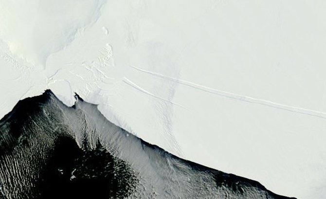
The region has seen some interesting activity recently. Notably, the ice which has been intact for about 15 years and which was the location of a landing strip has broken up. The ice breakup has had scarcely a mention in the news, and such mention of the ice breakup as there is points to the two large icebergs now adrift in the region.
The NASA image below, from November 30 2001, shows the relative locations of the Erebus Ice Tongue, the landing strip and Scott's Hut. In the original hi-res image, downloadable from the link given, a road can be seen running from the landing strip, past the end of the Erebus Ice Tongue to Scott's hut.
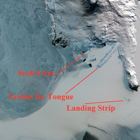
Erebus Ice Tongue location.
.

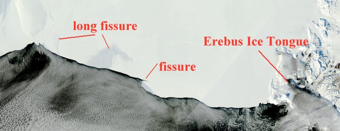
Three kinds of ice.
The bluish ice is the thinnest, most recent sea ice. Next is an expanse of older sea ice. The ice at lower right is glacial ice. Note the proximity of the glacial ice to the landing strip. It is this ice which recently detached to form the two ice islands.
.
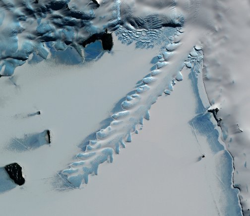
The Erebus Ice Tongue - detail showing sculpted edges.
.
The sea ice around the ice tongue is subject to frequent melting. The sculpting is caused by wave action. The sculpting feature is typical of all ice tongues in the area. The feature is of great assistance in helping to find ice tongues in old sea ice or shelves in satellite images.
Places to watch
Compared with the huge chunks of ice shelf which are likely to come adrift within the next few years, the two recently calved bergs are quite insignificant. From day to day, many parts of the ice shelf are obscured by clouds. However, in cloud-free areas there are many cracks to be seen in the shelf, mostly running parallel with the seaward edge. Only those nearest the edge need be of any immediate concern.
Cracks near the edge of the Ross Ice Shelf.
About midway along the ice shelf edge, a substantial crack is developing. The image below shows the crack and - in red - the size of ice island which I project is likely to result from the progression of the crack. The progression is based on low-level cloud formations. A crack too small to show up in a satellite image can caused turbulence and condensation, the pattern of which reveals the location of the crack.

Crack in Ross Ice Shelf - Feb 28 2011.
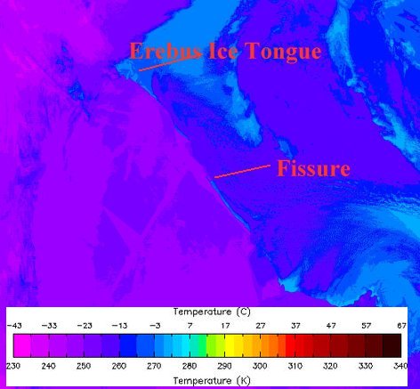
There is a very long fissure nearby, terminating in re-frozen fragments at left of image.
Fissures and fragments - Ross Ice Shelf - Feb 28 2011.
When water in these fissures freezes, it doesn't act like glue: rather, the newly expanding ice acts as a wedge, widening the crack.
A recent thermal image shows some interesting patterns which I call 'heat shadows'. Just as 'crop shadows' reveal the boundaries of buildings to archeologists, so - I suggest - these 'heat shadows' may reveal the shapes of old fragments of a previous ice shelf collapse. But I stand ready to be corrected by anyone with relevant expertise.
Thermal image - Ross Ice Shelf - Feb 28 2011
The heat shadows are the large dark areas within the ice shelf at left of the fissure.
The big question is - when will these ice islands calve from the ice edge? It is very difficult to judge. All I can say at the moment is: keep watching!
Image sources, NASA:
MODIS Rapid Response System
earthobservatory.nasa.gov


Comments